North Kansas City, Missouri facts for kids
Quick facts for kids
North Kansas City, Missouri
|
||
|---|---|---|

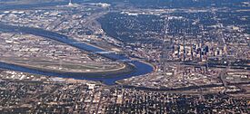
North Kansas City is depicted in the area on the left of the bend in the Missouri River.
|
||
|
||
| Nickname(s):
Northtown, NKC
|
||
| Motto(s):
Virtually Urban, Supremely Suburban
|
||

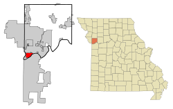
Location of North Kansas City, Missouri
|
||

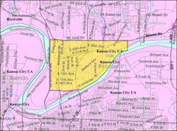
U.S. Census map
|
||
| Country | United States | |
| State | Missouri | |
| County | Clay | |
| Incorporated | November 4, 1912 | |
| Area | ||
| • Total | 4.610 sq mi (11.940 km2) | |
| • Land | 4.373 sq mi (11.325 km2) | |
| • Water | 0.237 sq mi (0.614 km2) | |
| Elevation | 745 ft (227 m) | |
| Population
(2020)
|
||
| • Total | 4,467 | |
| • Estimate
(2023)
|
5,534 | |
| • Density | 1,265.73/sq mi (488.71/km2) | |
| Time zone | UTC−6 (Central (CST)) | |
| • Summer (DST) | UTC−5 (CDT) | |
| ZIP Code |
64116
|
|
| Area code(s) | 816 and 975 | |
| FIPS code | 29-53102 | |
| GNIS feature ID | 2395255 | |
North Kansas City is a city in Clay County, Missouri, United States. It is located near the larger Kansas City. Even though their names are similar, North Kansas City is its own independent city. It is part of the bigger Kansas City metropolitan area. In 2020, about 4,467 people lived there.
North Kansas City was once a suburb across the Missouri River from Kansas City. Now, Kansas City has grown so much that it almost completely surrounds North Kansas City. The small town of Avondale is also nearby.
Contents
History of North Kansas City
A post office named North Kansas City was opened in 1891. The city got its name because it is located north of Kansas City.
Large-scale building in the area was not possible at first. This was because of floods from the Missouri River. To protect the city, strong walls called levees were built. The levee on the north side of the Missouri River was built between 1909 and 1912. It is still kept up by the North Kansas City Levee District. A hillside levee also helps protect the city.
The city officially became a city on November 4, 1912. In 1914, five people were chosen to manage the city's affairs. One of them was William E. Macken. He became the first mayor of North Kansas City in 1924. The city's biggest park, Macken Park, is named after him.
Some important buildings in North Kansas City are listed on the National Register of Historic Places. These include the Armour Theatre Building and the Sears, Roebuck and Company Warehouse Building.
In 2012, North Kansas City celebrated its 100th birthday! Since 2010, the city has seen new businesses open. These include two small breweries, a distillery, and a pickleball center. These new places were helped by more people moving back to downtown Kansas City, which is just across the Missouri River.
Geography and Location
North Kansas City is located at 39°08′22.58″N 94°33′50.97″W / 39.1396056°N 94.5641583°W. This is its exact spot on a map.
The city covers a total area of about 4.610 square miles (11.940 square kilometers). Most of this area, about 4.373 square miles (11.325 square kilometers), is land. The rest, about 0.237 square miles (0.614 square kilometers), is water.
Getting Around: Transportation
Many highways connect North Kansas City to the areas around it. These include Interstate 29/35/US 71. Other important routes are Missouri Route 1, Missouri Route 9, Missouri Route 210, Missouri Route 269, and Missouri Route 283. The US 169 freeway runs right next to the west side of North Kansas City.
Four bridges connect North Kansas City to the part of Kansas City that is south of the Missouri River. These bridges are:
- The Buck O'Neil Bridge on US 169
- The Heart of America Bridge on Route 9
- The Bond Bridge on I-29/35/US 71
- The Chouteau Bridge on Route 269
There is also a fifth bridge, the ASB Bridge. It used to carry both cars and trains, but now it is only for trains. The Heart of America Bridge also has a special path for bicycles and people walking. This path opened in October 2010.
People of North Kansas City: Demographics
| Historical population | |||
|---|---|---|---|
| Census | Pop. | %± | |
| 1920 | 870 | — | |
| 1930 | 2,574 | 195.9% | |
| 1940 | 2,688 | 4.4% | |
| 1950 | 3,886 | 44.6% | |
| 1960 | 5,657 | 45.6% | |
| 1970 | 5,183 | −8.4% | |
| 1980 | 4,507 | −13.0% | |
| 1990 | 4,130 | −8.4% | |
| 2000 | 4,714 | 14.1% | |
| 2010 | 4,208 | −10.7% | |
| 2020 | 4,467 | 6.2% | |
| 2023 (est.) | 5,534 | 31.5% | |
| U.S. Decennial Census 2020 Census |
|||
In 2023, there were about 2,891 homes in North Kansas City. On average, about 1.65 people lived in each home. The average income for a household was about $46,024. About 9.7% of the people in the city live below the poverty line.
About 71.4% of the people in North Kansas City have jobs. Also, 93.0% of the people have a high school diploma. About 31.6% have a bachelor's degree or higher.
The average age of people in the city was 47.1 years old.
Population in 2020
In 2020, there were 4,467 people living in North Kansas City. There were 2,564 households and 921 families. The city had about 1,021.5 people per square mile.
The people living in North Kansas City were from many different backgrounds:
- 70.94% were White
- 12.72% were African American
- 0.65% were Native American
- 2.69% were Asian
- 0.96% were Pacific Islander
- 4.03% were from other races
- 8.01% were from two or more races
About 10.14% of the population were Hispanic or Latino (who can be of any race).
About 14.5% of residents were under 18 years old. About 26.0% were 65 years or older. The population was almost evenly split between males (49.7%) and females (50.3%).
Learning and Schools: Education
Schools in the Area
The North Kansas City School District serves the area. Most homes in North Kansas City send their children to Briarcliff Elementary School. Some parts go to Crestview Elementary School. All students in North Kansas City attend Northgate Middle School and North Kansas City High School.
North Kansas City Library
The North Kansas City Library is located at 23rd and Howell. It offers books, magazines, DVDs, and music CDs to borrow. The city runs this library. It is not part of the larger Kansas City Public Library system.
Healthcare Services
North Kansas City Hospital was started in 1958. It is a main hospital with 451 beds. It provides important medical care for the community.
City Services: Infrastructure
Super Fast Internet: Fiberoptic Network
liNKCity is a special internet network run by the city itself. It is one of the first of its kind in Missouri. It offers super fast internet speeds, up to 1 gigabit per second. For all people living in the city, it is free and starts at 100 megabits per second.
The City of North Kansas City began building its own fiber optic network in 2005. Service started in 2006. In 2014, the city made a deal for a company called DataShack to manage liNKCity.
Famous People from North Kansas City
- Dan Lanning (born in 1986) is a well-known football coach. He is currently the head football coach for the Oregon Ducks.
See also
 In Spanish: North Kansas City (Misuri) para niños
 | Aurelia Browder |
 | Nannie Helen Burroughs |
 | Michelle Alexander |


