Edwardsville, Kansas facts for kids
Quick facts for kids
Edwardsville, Kansas
|
|
|---|---|

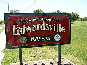
Entrance sign in Edwardsville (2016)
|
|

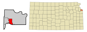
Location within Wyandotte County and Kansas
|
|
| Country | United States |
| State | Kansas |
| County | Wyandotte |
| Platted | 1869 |
| Incorporated | 1915 |
| Area | |
| • Total | 9.35 sq mi (24.23 km2) |
| • Land | 9.04 sq mi (23.41 km2) |
| • Water | 0.32 sq mi (0.82 km2) |
| Elevation | 781 ft (238 m) |
| Population
(2020)
|
|
| • Total | 4,717 |
| • Density | 504.5/sq mi (194.68/km2) |
| Time zone | UTC-6 (CST) |
| • Summer (DST) | UTC-5 (CDT) |
| ZIP codes |
66111, 66113
|
| Area code | 913 |
| FIPS code | 20-20000 |
| GNIS ID | 478886 |
Edwardsville is a city located in Wyandotte County, Kansas, in the United States. It is part of the larger Kansas City Metropolitan Area. In 2020, about 4,717 people lived in Edwardsville.
Contents
History of Edwardsville
Edwardsville was first mapped out in 1869. The land where the city now stands used to belong to Half Moon, a chief of the Delaware Native American tribe. The city was named after John H. Edwards. He was an important person for the Union Pacific Railroad. Later, he also served as a judge and a state senator.
Geography and Location
Edwardsville is located at 39°03′48″N 94°48′52″W / 39.063428°N 94.814347°W. The city covers a total area of about 9.36 square miles (24.23 square kilometers). Most of this area, about 9.04 square miles (23.41 square kilometers), is land. The remaining 0.32 square miles (0.82 square kilometers) is water.
Population and People
Edwardsville is part of the Kansas City Metropolitan Area. It is also part of a special type of local government called a unified government. This government also includes Kansas City, Kansas, parts of Bonner Springs, and a small part of Lake Quivira.
How Edwardsville's Population Grew
The number of people living in Edwardsville has changed over many years. Here is a look at the population during different census years:
| Historical population | |||
|---|---|---|---|
| Census | Pop. | %± | |
| 1880 | 106 | — | |
| 1920 | 203 | — | |
| 1930 | 228 | 12.3% | |
| 1940 | 243 | 6.6% | |
| 1950 | 274 | 12.8% | |
| 1960 | 513 | 87.2% | |
| 1970 | 619 | 20.7% | |
| 1980 | 3,364 | 443.5% | |
| 1990 | 3,979 | 18.3% | |
| 2000 | 4,146 | 4.2% | |
| 2010 | 4,340 | 4.7% | |
| 2020 | 4,717 | 8.7% | |
| U.S. Decennial Census | |||
Edwardsville in 2020
In 2020, the 2020 United States census counted 4,717 people living in Edwardsville. There were 1,682 households and 1,181 families. The population density was about 522 people per square mile.
About 25.6% of the people were under 18 years old. The average age in the city was 36.9 years. For every 100 females, there were about 101 males.
Education in Edwardsville
Students in Edwardsville attend schools in the Bonner Springs–Edwardsville USD 204 public school district.
Famous People from Edwardsville
- Junius George Groves (1859–1925) was a successful businessman and farmer who lived in Edwardsville.
See also
 In Spanish: Edwardsville (Kansas) para niños
 | James Van Der Zee |
 | Alma Thomas |
 | Ellis Wilson |
 | Margaret Taylor-Burroughs |

