Kansas, Ohio facts for kids
Quick facts for kids
Kansas, Ohio
|
|
|---|---|

Community post office
|
|

Location of Kansas, Ohio
|
|
| Country | United States |
| State | Ohio |
| County | Seneca |
| Township | Liberty |
| Area | |
| • Total | 0.44 sq mi (1.14 km2) |
| • Land | 0.44 sq mi (1.14 km2) |
| • Water | 0.00 sq mi (0.00 km2) |
| Elevation | 728 ft (222 m) |
| Population
(2020)
|
|
| • Total | 175 |
| • Density | 398.63/sq mi (153.85/km2) |
| Time zone | UTC-5 (Eastern (EST)) |
| • Summer (DST) | UTC-4 (EDT) |
| ZIP codes |
44841
|
| FIPS code | 39-39578 |
| GNIS feature ID | 2628908 |
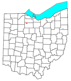
Kansas is a small community located in Liberty Township, Seneca County, Ohio, in the United States. It's known as a census-designated place, which means it's a community that isn't officially a city or town, but its population is still counted by the government.
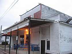
This community has its own post office and uses the ZIP code 44841. You can find Kansas along State Route 635. According to the 2020 census, 175 people live in Kansas.
History of Kansas, Ohio
Kansas was officially planned and mapped out, a process called "platting," in early 1855. It was developed along the route of the Lake Erie and Louisville Railroad, which was an important railway line at the time.
The community was named after the Kansas Territory. This territory was a region in the central United States that was being settled around the same time. Just a short distance south of Kansas, along State Route 635, you can find the Michaels Farm. This farm is a special place because it has been recognized as a historic site.
Population of Kansas
The population of Kansas, Ohio, was counted during the 2020 census. At that time, 175 people lived in the community.
See also
- In Spanish: Kansas (Ohio) para niños
 | Selma Burke |
 | Pauline Powell Burns |
 | Frederick J. Brown |
 | Robert Blackburn |

