Pawnee County, Nebraska facts for kids
Quick facts for kids
Pawnee County
|
|
|---|---|

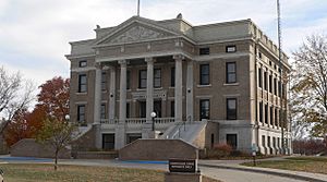
Pawnee County Courthouse in Pawnee City
|
|

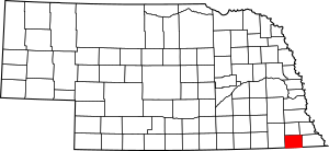
Location within the U.S. state of Nebraska
|
|
 Nebraska's location within the U.S. |
|
| Country | |
| State | |
| Founded | 1854 |
| Named for | Pawnee people |
| Seat | Pawnee City |
| Largest city | Pawnee City |
| Area | |
| • Total | 433 sq mi (1,120 km2) |
| • Land | 431 sq mi (1,120 km2) |
| • Water | 1.9 sq mi (5 km2) 0.4%% |
| Population
(2020)
|
|
| • Total | 2,544 |
| • Density | 5.875/sq mi (2.2685/km2) |
| Time zone | UTC−6 (Central) |
| • Summer (DST) | UTC−5 (CDT) |
| Congressional district | 3rd |
Pawnee County is a place in Nebraska, a state in the United States. In 2020, about 2,544 people lived there. The main town, or county seat, is Pawnee City.
When Nebraska started its license plate system in 1922, Pawnee County was given the number 54. This was because it had the 54th largest number of cars registered at that time.
Contents
History of Pawnee County
Pawnee County was created in 1854. It got its name from the Pawnee people, a Native American tribe.
On May 30, 1879, a very strong tornado, called the "Irving, Kansas Tornado," moved through Pawnee County. This tornado was huge, about 800 yards wide, and traveled for 100 miles.
Geography of Pawnee County
Pawnee County is located in the southern part of Nebraska. Its southern border touches the state of Kansas. The Big Nemaha River flows through the northeast part of the county. Smaller streams also flow through the county and join the Big Nemaha River.
The land in Pawnee County has rolling hills. Much of the flat land is used for farming. The county covers about 433 square miles. Most of this area, about 431 square miles, is land. Only a small part, about 1.9 square miles, is water.
Main Roads in Pawnee County
Neighboring Counties
- Richardson County – to the east
- Nemaha County, Kansas – to the southeast
- Marshall County, Kansas – to the southwest
- Gage County – to the west
- Johnson County – to the north
- Nemaha County – to the northeast
Protected Natural Areas
- Bowwood State Wildlife Management Area
- Burchard State Wildlife Management Area
- Mayberry State Wildlife Management Area
- Pawnee Prairie State Wildlife Management Area
- Prairie Knoll State Wildlife Management Area
- Table Rock State Wildlife Management Area
Population of Pawnee County
| Historical population | |||
|---|---|---|---|
| Census | Pop. | %± | |
| 1860 | 882 | — | |
| 1870 | 4,171 | 372.9% | |
| 1880 | 6,920 | 65.9% | |
| 1890 | 10,340 | 49.4% | |
| 1900 | 11,770 | 13.8% | |
| 1910 | 10,582 | −10.1% | |
| 1920 | 9,578 | −9.5% | |
| 1930 | 9,423 | −1.6% | |
| 1940 | 8,514 | −9.6% | |
| 1950 | 6,744 | −20.8% | |
| 1960 | 5,356 | −20.6% | |
| 1970 | 4,473 | −16.5% | |
| 1980 | 3,937 | −12.0% | |
| 1990 | 3,317 | −15.7% | |
| 2000 | 3,087 | −6.9% | |
| 2010 | 2,773 | −10.2% | |
| 2020 | 2,544 | −8.3% | |
| 2022 (est.) | 2,528 | −8.8% | |
| US Decennial Census 1790-1960 1900-1990 1990-2000 2010 2020 2022 |
|||
In 2000, there were 3,087 people living in Pawnee County. The population density was about 7 people per square mile. Most of the people living in the county were White.
About 22.7% of the people were under 18 years old. About 27.1% were 65 years old or older. The average age was 46 years.
Towns and Villages in Pawnee County
Cities
- Pawnee City (This is the main town, also called the county seat.)
Villages
See also
 In Spanish: Condado de Pawnee (Nebraska) para niños
 | Janet Taylor Pickett |
 | Synthia Saint James |
 | Howardena Pindell |
 | Faith Ringgold |

