Nemaha County, Nebraska facts for kids
Quick facts for kids
Nemaha County
|
|
|---|---|

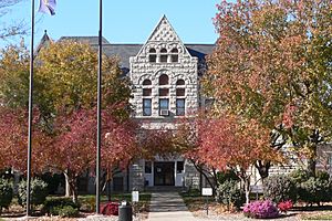
Nemaha County Courthouse in Auburn
|
|

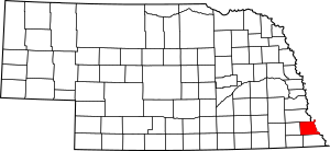
Location within the U.S. state of Nebraska
|
|
 Nebraska's location within the U.S. |
|
| Country | |
| State | |
| Founded | 1855 |
| Seat | Auburn |
| Largest city | Auburn |
| Area | |
| • Total | 410 sq mi (1,100 km2) |
| • Land | 407 sq mi (1,050 km2) |
| • Water | 2.2 sq mi (6 km2) 0.5%% |
| Population | |
| • Estimate
(2021)
|
7,064 |
| • Density | 17.2/sq mi (6.6/km2) |
| Time zone | UTC−6 (Central) |
| • Summer (DST) | UTC−5 (CDT) |
| Congressional district | 3rd |
Nemaha County is a county in the state of Nebraska, USA. It is located in the eastern part of Nebraska. As of 2020, about 7,074 people lived there. The main town for the county government is Auburn, which is called the county seat.
If you look at Nebraska license plates, Nemaha County has the number 44. This is because it had the 44th largest number of vehicles registered when the system started in 1922.
Contents
History of Nemaha County
Nemaha County has a very interesting past! It was once part of a special area called the Nemaha Half-Breed Reservation. This land was set aside in 1830 for the children of traders and Native Americans.
The county's first community was Saint Deroin. It was started in 1853 as a trading post on the Missouri River. Today, you can find this spot within Indian Cave State Park.
In 1854, white settlers were allowed into the area. This happened because of something called the Kansas–Nebraska Act. At first, this land was part of Forney County. But in 1855, Nemaha County was officially created. Brownville became its first county seat.
Brownville was the biggest city in Nebraska back then. Many important things happened there:
- In 1861, the first state normal school was founded. This school is now known as Peru State College.
- On January 1, 1863, Daniel Freeman made the first claim under the Homestead Act of 1862. This act allowed people to get free land if they lived on it and farmed it. He filed his claim at the Brownville land office.
The Nebraska State Fair was held in Brownville in 1870 and 1871.
Later, in 1883, the county seat was moved to Auburn.
In 1974, the Cooper Nuclear Station was built south of Brownville. This is a power plant that uses nuclear energy.
Geography and Nature
Nemaha County is on the eastern side of Nebraska. Its eastern border touches the state of Missouri, across the Missouri River. Most of the county's eastern edge follows the Missouri River.
There's a unique spot called McKissick Island in the very northeast corner. It's a piece of land that used to be part of the river's path. Now, it's almost like a small island that belongs to Nebraska but is east of the current river channel.
The Nemaha River flows through the upper eastern part of the county. It eventually empties into the Missouri River near the village of Nemaha.
The county has gentle, rolling hills. These hills slope down towards the Missouri River valley. A lot of the land is used for farming. Nemaha County covers about 410 square miles. Most of this (407 square miles) is land, and a small part (2.2 square miles) is water.
Main Roads
Parks and Protected Areas
- Indian Cave State Park (part of it is in Nemaha County)
Neighboring Counties
- Otoe County - to the north
- Atchison County, Missouri - to the east
- Holt County, Missouri - to the southeast
- Richardson County - to the south
- Pawnee County - to the southwest
- Johnson County - to the west
People of Nemaha County
| Historical population | |||
|---|---|---|---|
| Census | Pop. | %± | |
| 1860 | 3,139 | — | |
| 1870 | 7,593 | 141.9% | |
| 1880 | 10,451 | 37.6% | |
| 1890 | 12,930 | 23.7% | |
| 1900 | 14,952 | 15.6% | |
| 1910 | 13,095 | −12.4% | |
| 1920 | 12,547 | −4.2% | |
| 1930 | 12,356 | −1.5% | |
| 1940 | 12,781 | 3.4% | |
| 1950 | 10,973 | −14.1% | |
| 1960 | 9,099 | −17.1% | |
| 1970 | 8,976 | −1.4% | |
| 1980 | 8,367 | −6.8% | |
| 1990 | 7,980 | −4.6% | |
| 2000 | 7,576 | −5.1% | |
| 2010 | 7,248 | −4.3% | |
| 2020 | 7,074 | −2.4% | |
| 2021 (est.) | 7,064 | −2.5% | |
| US Decennial Census 1790-1960 1900-1990 1990-2000 2010-2013 |
|||
In 2000, there were 7,576 people living in Nemaha County. There were 3,047 households, which are groups of people living together. About 1,980 of these were families.
The population density was about 18 people per square mile. Most of the people (97.60%) were White. A small number were Black, Native American, or Asian. About 1% of the population was Hispanic or Latino.
About 29.50% of households had children under 18 living with them. About 16.20% of households had someone living alone who was 65 or older. The average household had 2.32 people.
The population was made up of different age groups:
- 23.20% were under 18 years old.
- 11.90% were between 18 and 24.
- 23.90% were between 25 and 44.
- 22.70% were between 45 and 64.
- 18.40% were 65 years or older.
The average age in the county was 39 years old.
Towns and Villages
Cities
Villages
Unincorporated Communities
These are smaller communities that are not officially organized as cities or villages.
Ghost Town
- St. Deroin (This was the county's first community, but it no longer exists as a town)
Precincts
Nemaha County is divided into smaller areas called precincts. These are similar to townships.
- Aspinwall
- Bedford
- Benton
- Brownville
- Douglas
- Glen Rock
- Lafayette
- London
- McKissick Island
- Nemaha
- Peru
- St. Deroin
- Washington
See also
 In Spanish: Condado de Nemaha (Nebraska) para niños
 | Jackie Robinson |
 | Jack Johnson |
 | Althea Gibson |
 | Arthur Ashe |
 | Muhammad Ali |

