Brownville, Nebraska facts for kids
Quick facts for kids
Brownville, Nebraska
|
|
|---|---|
|
Village
|
|

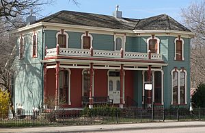
Carson House on Main Street, in Brownville Historic District
|
|

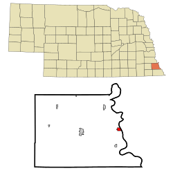
Location of Brownville, Nebraska
|
|
| Country | United States |
| State | Nebraska |
| County | Nemaha |
| Area | |
| • Total | 0.65 sq mi (1.69 km2) |
| • Land | 0.65 sq mi (1.69 km2) |
| • Water | 0.00 sq mi (0.00 km2) |
| Elevation | 958 ft (292 m) |
| Population
(2020)
|
|
| • Total | 142 |
| • Estimate
(2021)
|
142 |
| • Density | 218.5/sq mi (84.0/km2) |
| Time zone | UTC-6 (Central (CST)) |
| • Summer (DST) | UTC-5 (CDT) |
| ZIP code |
68321
|
| Area code(s) | 402 |
| FIPS code | 31-06750 |
| GNIS feature ID | 0827698 |
Brownville is a small village in Nemaha County, Nebraska, United States. In 2020, about 142 people lived there. It's a place with a lot of history, especially because it's located near the Missouri River.
Contents
History of Brownville
Brownville was started in 1854 and became an official village in 1856. It quickly grew to be the biggest town in the Nebraska Territory. By 1880, its population was 1,309 people.
Because it was right next to Missouri, which allowed slavery at the time, Brownville became an important port on the Missouri River. Ships called steamboats would stop there.
A very important event happened in Brownville. Daniel Freeman was the first person to claim land under the Homestead Act of 1862. This law allowed people to get free land from the government if they lived on it and farmed it for five years. Freeman made his claim at a New Year's Eve party in Brownville.
How Railroads Changed Brownville
The growth of railroads eventually caused problems for Brownville. Trains started taking over from steamboats for moving goods and people. Brownville tried to get its own railroad, but the plan failed badly. This led to huge tax increases for the town's people.
Many people moved away because of the high taxes. In 1885, the county seat (the main town for the county government) was moved to Auburn.
Important People and Events
In 1856, Thomas Weston Tipton moved to Brownville to work as a minister. He later became a U.S. Senator for Nebraska. He also tried to become the Governor of Nebraska, but he didn't win.
After the American Civil War, David Henry Mercer started a law business in Brownville. Mercer later served for a long time as a U.S. Representative from Nebraska.
The Nebraska State Fair was held in Brownville in 1870 and 1871. In 1871, Eugene Allen Gilmore, who later became the acting Governor-General of the Philippines, was born in Brownville.
Brownville Today
The Brownville Bridge was built over the Missouri River in 1939. Today, it is listed on the National Register of Historic Places because of its historical importance.
Brownville is now mainly a place for tourists. Many old houses are open for tours or have been turned into museums. There are also art galleries and wineries nearby. These places make Brownville a fun place to visit for people from bigger cities.
The River City Star, a boat from Omaha, was built in Brownville in 1967. It was first called the Belle of Brownville. The Governor Furnas Arboretum was planted in the village in 1992. An arboretum is a place where many different kinds of trees are grown. It is named after Robert W. Furnas, Nebraska's second governor, who signed the first declaration for Arbor Day. The Cooper Nuclear Station, a power plant, is located south of the village.
Geography
Brownville is located in the Loess Hills area, which is above the Missouri River Valley. The village has a total area of about 0.65 square miles (1.69 square kilometers), and all of it is land.
Climate
| Climate data for Brownville, Nebraska | |||||||||||||
|---|---|---|---|---|---|---|---|---|---|---|---|---|---|
| Month | Jan | Feb | Mar | Apr | May | Jun | Jul | Aug | Sep | Oct | Nov | Dec | Year |
| Record high °F (°C) | 70 (21) |
81 (27) |
91 (33) |
99 (37) |
102 (39) |
109 (43) |
110 (43) |
109 (43) |
107 (42) |
98 (37) |
84 (29) |
78 (26) |
110 (43) |
| Mean daily maximum °F (°C) | 34 (1) |
41 (5) |
53 (12) |
65 (18) |
76 (24) |
86 (30) |
90 (32) |
88 (31) |
80 (27) |
68 (20) |
50 (10) |
37 (3) |
64 (18) |
| Mean daily minimum °F (°C) | 14 (−10) |
20 (−7) |
30 (−1) |
41 (5) |
52 (11) |
62 (17) |
66 (19) |
64 (18) |
55 (13) |
43 (6) |
30 (−1) |
18 (−8) |
41 (5) |
| Record low °F (°C) | −22 (−30) |
−23 (−31) |
−21 (−29) |
7 (−14) |
26 (−3) |
39 (4) |
43 (6) |
38 (3) |
23 (−5) |
13 (−11) |
−5 (−21) |
−27 (−33) |
−27 (−33) |
| Average precipitation inches (mm) | 0.84 (21) |
1.09 (28) |
2.46 (62) |
2.93 (74) |
4.27 (108) |
3.73 (95) |
4.41 (112) |
3.49 (89) |
3.54 (90) |
2.49 (63) |
2.02 (51) |
1.09 (28) |
32.36 (821) |
| Average snowfall inches (cm) | 5.7 (14) |
6.2 (16) |
5.3 (13) |
1 (2.5) |
0 (0) |
0 (0) |
0 (0) |
0 (0) |
0 (0) |
0.2 (0.51) |
1.7 (4.3) |
5.7 (14) |
25.8 (64.31) |
Population Information
| Historical population | |||
|---|---|---|---|
| Census | Pop. | %± | |
| 1860 | 425 | — | |
| 1870 | 1,305 | 207.1% | |
| 1880 | 1,309 | 0.3% | |
| 1890 | 980 | −25.1% | |
| 1900 | 718 | −26.7% | |
| 1910 | 457 | −36.4% | |
| 1920 | 463 | 1.3% | |
| 1930 | 426 | −8.0% | |
| 1940 | 581 | 36.4% | |
| 1950 | 357 | −38.6% | |
| 1960 | 243 | −31.9% | |
| 1970 | 174 | −28.4% | |
| 1980 | 203 | 16.7% | |
| 1990 | 148 | −27.1% | |
| 2000 | 146 | −1.4% | |
| 2010 | 132 | −9.6% | |
| 2020 | 139 | 5.3% | |
| 2021 (est.) | 142 | 7.6% | |
| U.S. Decennial Census | |||
2010 Census Details
According to the census from 2010, Brownville had 132 people living in 73 households. About 40 of these households were families. The village had 103 housing units.
The average household size was 1.81 people, and the average family size was 2.30 people.
The median age in the village was 60.8 years old.
- About 6.8% of residents were under 18.
- About 6.9% were between 18 and 24.
- About 7.6% were between 25 and 44.
- About 40.1% were between 45 and 64.
- About 38.6% were 65 years or older.
The population was made up of 53.0% males and 47.0% females.
Places to See
Brownville is located in the Loess Hills above the Missouri River Valley. It is home to one of Nebraska's two nuclear power plants, called the Cooper Nuclear Station. This plant is owned and run by the Nebraska Public Power District.
U.S. Route 136 runs through Brownville and meets Nebraska Highway 67 nearby. This route then crosses the Brownville Bridge to leave the state. Bicycle riders on the Lewis & Clark Trail Bicycle Route can choose between two paths here: the Steamboat Trace or the Hamburg Option.
Notable People
- Eugene Allen Gilmore: He was the acting Governor-General of the Philippines in 1927.
- Thomas Tipton: He was one of the first two U.S. Senators from Nebraska.
See also
 In Spanish: Brownville (Nebraska) para niños
 | George Robert Carruthers |
 | Patricia Bath |
 | Jan Ernst Matzeliger |
 | Alexander Miles |

