Nemaha, Nebraska facts for kids
Quick facts for kids
Nemaha, Nebraska
|
|
|---|---|
|
Village
|
|

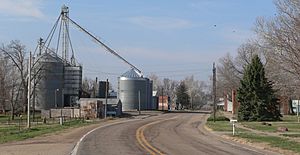
Nemaha, seen from the north along Nebraska Highway 67
|
|

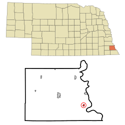
Location of Nemaha, Nebraska
|
|
| Country | United States |
| State | Nebraska |
| County | Nemaha |
| Area | |
| • Total | 0.30 sq mi (0.79 km2) |
| • Land | 0.30 sq mi (0.79 km2) |
| • Water | 0.00 sq mi (0.00 km2) |
| Elevation | 912 ft (278 m) |
| Population
(2020)
|
|
| • Total | 116 |
| • Estimate
(2021)
|
115 |
| • Density | 387/sq mi (146.8/km2) |
| Time zone | UTC-6 (Central (CST)) |
| • Summer (DST) | UTC-5 (CDT) |
| ZIP code |
68414
|
| Area code(s) | 402 |
| FIPS code | 31-33950 |
| GNIS feature ID | 0831589 |
Nemaha is a small village located in Nemaha County, Nebraska, in the United States. It's a quiet place with a population of 116 people, according to the 2020 census. The village is named after the Nemaha River, which flows nearby.
Contents
A Look Back: Nemaha's History
Nemaha officially became a village in 1856. It was named after the Nemaha River, which is an important river in the area.
Where is Nemaha? Geography Facts
Nemaha is located at specific coordinates: 40.338806 degrees North and 95.675274 degrees West. This means it's in the northern hemisphere and western hemisphere.
The village covers a total area of about 0.79 square kilometers (0.30 square miles). All of this area is land, meaning there are no large lakes or rivers within the village limits.
Who Lives in Nemaha? Population Changes
| Historical population | |||
|---|---|---|---|
| Census | Pop. | %± | |
| 1900 | 400 | — | |
| 1910 | 325 | −18.7% | |
| 1920 | 351 | 8.0% | |
| 1930 | 296 | −15.7% | |
| 1940 | 379 | 28.0% | |
| 1950 | 288 | −24.0% | |
| 1960 | 232 | −19.4% | |
| 1970 | 207 | −10.8% | |
| 1980 | 209 | 1.0% | |
| 1990 | 188 | −10.0% | |
| 2000 | 178 | −5.3% | |
| 2010 | 149 | −16.3% | |
| 2020 | 114 | −23.5% | |
| 2021 (est.) | 115 | −22.8% | |
| U.S. Decennial Census | |||
Nemaha's Population in 2010
In 2010, the village of Nemaha had 149 people living there. These people lived in 71 different homes. About half of these homes (36) were families.
The population density was about 496.7 people per square mile. This means that for every square mile of land, there were almost 500 people. There were also 90 housing units, which are places where people can live.
Most of the people living in Nemaha in 2010 were White (99.3%). A small number (0.7%) were African American.
The average age of people in Nemaha was 46.2 years old. About 22.1% of the residents were under 18 years old. About 22.8% were 65 years old or older. The village had slightly more males (51.7%) than females (48.3%).
Learning in Nemaha: School Information
Students in Nemaha attend schools within the Humboldt Table Rock Steinauer School District. This district was formed on January 1, 2009, when the former Southeast Nebraska Consolidated Schools merged into it.
Famous People from Nemaha
- Lunsford E. Oliver: He was a major general in the United States Army. He led the 5th Armored Division during World War II.
See also
 In Spanish: Nemaha (Nebraska) para niños
 | Shirley Ann Jackson |
 | Garett Morgan |
 | J. Ernest Wilkins Jr. |
 | Elijah McCoy |

