
McKissick Island facts for kids
McKissick Island, also known as McKissick's Island, is a unique piece of land in the United States. Even though it's part of Nemaha County, Nebraska, it sits on the east side of the Missouri River. This means you can only reach it by land if you travel through parts of Iowa and Missouri first!
People sometimes call it a "Nebraska island" inside Missouri. It's not a true island anymore because the river changed course. For many years, there was a disagreement between Missouri and Nebraska about who owned the land. This was finally settled in 1904 by the United States Supreme Court and then officially agreed upon by both states in 1999.
McKissick Island is about 5,000 acres big. It has always had very few people living there. In 2006, reports said there was only one house on the island! The road signs on the island use the street names from Nemaha County, Nebraska, even though it's surrounded by Atchison County, Missouri.
Contents
What's in a Name?
McKissick Island got its name from the McKissick family. They bought land in this area in the 1840s. At that time, the borders between Missouri, Nebraska, and Iowa weren't fully set. The family were some of the first settlers in Fremont County, Iowa. They even started a place called McKissick's Grove, thinking it was in Missouri. But when Iowa became a state in 1846, that grove was found to be in Iowa.
The McKissick family moved to California in 1861.
The official name for the land is "McKissick Island" according to the Geographic Names Information System. However, you might see it called "McKissick's Island" on some maps. The Supreme Court, in its 1904 decision, also called it "McKissick's Island."
A Shifting History
Early Maps and Borders
In 1837, a map of the Missouri River, possibly made by Robert E. Lee, showed McKissick Island on the Nebraska side. When Nebraska officially became a state on March 1, 1867, its borders included McKissick's Island. Missouri had already expanded its border to the Missouri River in 1836, but it didn't claim the island back then.
River Changes and Earthquakes
On April 24, 1867, a strong earthquake (5.1 on the Richter magnitude scale) happened about 130 miles from the island. It shook Missouri, Kansas, Nebraska, and Iowa. While there's no direct proof, some people believe this earthquake might have played a part in how the Missouri River changed its path around the island.
Just over four months after Nebraska became a state, on July 5, 1867, a big flood changed the river's course. The flood created a new channel on the west side of the island, making the river flow straighter. Later, in the 1880s, another flood made this new channel even deeper. Meanwhile, the old riverbed on the east side of the island dried up. This made the land seem connected to Missouri, and people from Nebraska had to use a ferry to get to it.
The Border Dispute
In 1895, surveyors from Nemaha County (Nebraska) and Atchison County (Missouri) mapped the old, dried-up riverbed.
On February 24, 1904, Missouri took its claim over the island to the Supreme Court. Nebraska also filed a lawsuit. Missouri argued that when Congress approved its borders, the boundary should have been the middle of the river. Nebraska argued that its borders were set when it became a state.
Justice John Marshall Harlan explained the court's decision. He said that if a river gradually changes its course, the land boundary also changes with it. This means that if you gain land because the river moves, you also risk losing land the same way. The court told the states to either accept the 1895 survey or ask for a new one.
The border wasn't fully settled until 1999. That's when Missouri and Nebraska agreed to a new survey and signed the Missouri-Nebraska Compact, which was approved by the United States Congress.
Life on the Island
For many years, McKissick Island had a small community. In 1897, a Methodist church was built there, and there was also a school. In 1907, about 30 families lived on the island, with 56 children. In 1966, there were seven families and eleven students. These students went to school in Hamburg, Iowa, which meant they had to travel from Nebraska, through Missouri, and then into Iowa to get to school! The old schoolhouse was even used as a place for people to vote.
During the 2011 Missouri River Flood, most of McKissick Island was covered by 2 to 10 feet of water because the levees protecting it broke.
Images for kids
-
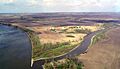
View from the south showing where the Nishnabotna River meets the Missouri River.
-
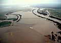
View from the north during the 2011 Missouri River flood, showing the island underwater.
-
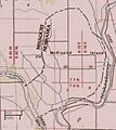
A section of the official map of the area.


See also
 In Spanish: Isla McKissick para niños
