Fremont County, Iowa facts for kids
Quick facts for kids
Fremont County
|
|
|---|---|

Fremont County Courthouse
|
|

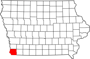
Location within the U.S. state of Iowa
|
|
 Iowa's location within the U.S. |
|
| Country | |
| State | |
| Founded | 1847 |
| Named for | John C. Fremont |
| Seat | Sidney |
| Largest city | Sidney |
| Area | |
| • Total | 517 sq mi (1,340 km2) |
| • Land | 511 sq mi (1,320 km2) |
| • Water | 5.5 sq mi (14 km2) 1.1% |
| Population
(2020)
|
|
| • Total | 6,605 |
| • Density | 12.776/sq mi (4.933/km2) |
| Time zone | UTC−6 (Central) |
| • Summer (DST) | UTC−5 (CDT) |
| Congressional district | 3rd |
Fremont County is a county in the state of Iowa. It's located in the U.S.. In 2020, about 6,605 people lived here. This makes it one of the least populated counties in Iowa.
The main town, or county seat, is Sidney. Fremont County was created in 1847. It was named after John C. Frémont, who was a military officer.
Contents
Geography of Fremont County
Fremont County covers a total area of about 517 square miles. Most of this area, about 511 square miles, is land. The rest, about 5.5 square miles, is water.
Main Roads in Fremont County
These are the important highways that go through Fremont County:
Neighboring Counties
Fremont County shares borders with these other counties:
- Mills County (to the north)
- Page County (to the east)
- Atchison County, Missouri (to the south)
- Otoe County, Nebraska (to the southwest)
- Cass County, Nebraska (to the northwest)
History of Fremont County
Fremont County was affected by big floods in 2019. These were part of the 2019 Midwestern U.S. floods. After the floods, there were talks about buying out homes in towns like Hamburg and McPaul. This means the government might buy homes from people who live in areas that flood often.
People of Fremont County
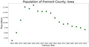
| Historical population | |||
|---|---|---|---|
| Census | Pop. | %± | |
| 1850 | 1,244 | — | |
| 1860 | 5,074 | 307.9% | |
| 1870 | 11,174 | 120.2% | |
| 1880 | 17,652 | 58.0% | |
| 1890 | 16,842 | −4.6% | |
| 1900 | 18,546 | 10.1% | |
| 1910 | 15,623 | −15.8% | |
| 1920 | 15,447 | −1.1% | |
| 1930 | 15,533 | 0.6% | |
| 1940 | 14,645 | −5.7% | |
| 1950 | 12,323 | −15.9% | |
| 1960 | 10,282 | −16.6% | |
| 1970 | 9,282 | −9.7% | |
| 1980 | 9,401 | 1.3% | |
| 1990 | 8,226 | −12.5% | |
| 2000 | 8,010 | −2.6% | |
| 2010 | 7,441 | −7.1% | |
| 2020 | 6,605 | −11.2% | |
| 2023 (est.) | 6,458 | −13.2% | |
| U.S. Decennial Census 1790-1960 1900-1990 1990-2000 2010-2018 |
|||
2020 Census Information

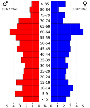
The 2020 census counted 6,605 people living in Fremont County. This means there were about 13 people per square mile. Most people, about 95.65%, said they belonged to one race. About 91% were non-Hispanic White. Other groups included Hispanic, Black, Native American, and Asian people. There were also people who identified as more than one race.
The county had 3,110 housing units. Out of these, 2,720 homes were lived in.
2010 Census Information
In 2010, the census showed that 7,441 people lived in the county. There were about 15 people per square mile. At that time, there were 3,431 housing units, and 3,064 of them were occupied.
Towns and Areas
Cities in Fremont County
Census-Designated Places
These are areas that are like towns but are not officially incorporated as cities:
Other Unincorporated Places
Townships
Fremont County is divided into thirteen smaller areas called townships:
- Benton
- Fisher
- Green
- Locust Grove
- Madison
- Monroe
- Prairie
- Riverside
- Riverton
- Scott
- Sidney
- Walnut
- Washington
Population Ranking of Towns
This table shows the population of cities and places in Fremont County, based on the 2020 census.
† This symbol means it is the county seat.
| Rank | City, town, etc. | Type of Place | Population (2020 Census) |
|---|---|---|---|
| 1 | † Sidney | City | 1,070 |
| 2 | Hamburg | City | 890 |
| 3 | Tabor (partially in Mills County) | City | 928 (1,014 total) |
| 4 | Farragut | City | 490 |
| 5 | Riverton | City | 245 |
| 6 | Randolph | City | 189 |
| 7 | Thurman | City | 167 |
| 8 | Percival | CDP | 53 |
| 9 | Imogene | City | 39 |
| 10 | Anderson | CDP | 37 |
| 11 | Bartlett | CDP | 5 |
| 12 | Shenandoah (mostly in Page County) | City | 0 (4,925 total) |
Schools in Fremont County
Here are the school districts that serve students in Fremont County:
- Fremont-Mills Community School District
- Hamburg Community School District
- Shenandoah Community School District
- Sidney Community School District
A school district that used to be here:
- Farragut Community School District
See also
 In Spanish: Condado de Fremont (Iowa) para niños
 | Janet Taylor Pickett |
 | Synthia Saint James |
 | Howardena Pindell |
 | Faith Ringgold |


