Farragut, Iowa facts for kids
Quick facts for kids
Farragut, Iowa
|
|
|---|---|
 |
|

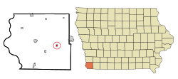
Location of Farragut, Iowa
|
|
| Country | |
| State | |
| County | Fremont |
| Area | |
| • Total | 0.40 sq mi (1.04 km2) |
| • Land | 0.40 sq mi (1.04 km2) |
| • Water | 0.00 sq mi (0.00 km2) |
| Elevation | 961 ft (293 m) |
| Population
(2020)
|
|
| • Total | 490 |
| • Density | 1,221.95/sq mi (471.76/km2) |
| Time zone | UTC-6 (Central (CST)) |
| • Summer (DST) | UTC-5 (CDT) |
| ZIP code |
51639
|
| Area code(s) | 712 |
| FIPS code | 19-26985 |
| GNIS feature ID | 2394751 |
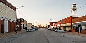
Farragut is a small city located in Fremont County, Iowa, in the United States. In 2020, about 490 people lived there.
Contents
History of Farragut
Farragut started around the year 1870. This was when the Burlington & Missouri River Railroad was built through the area. The city is named after Admiral David Farragut, a famous naval officer.
Geography of Farragut
Farragut is located close to the East Nishnabotna River.
The city covers a total area of about 0.41 square miles (1.04 square kilometers). All of this area is land.
Population and People
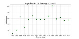
| Historical populations | ||
|---|---|---|
| Year | Pop. | ±% |
| 1880 | 380 | — |
| 1890 | 406 | +6.8% |
| 1900 | 514 | +26.6% |
| 1910 | 431 | −16.1% |
| 1920 | 494 | +14.6% |
| 1930 | 523 | +5.9% |
| 1940 | 496 | −5.2% |
| 1950 | 495 | −0.2% |
| 1960 | 495 | +0.0% |
| 1970 | 521 | +5.3% |
| 1980 | 603 | +15.7% |
| 1990 | 498 | −17.4% |
| 2000 | 509 | +2.2% |
| 2010 | 485 | −4.7% |
| 2020 | 490 | +1.0% |
| Source: and Iowa Data Center Source: |
||
2020 Population Count
In 2020, the census showed 490 people living in Farragut. There were 221 households and 126 families. The city had about 1,222 people per square mile.
Most residents, about 94.7%, were White. About 2.0% of the population identified as Hispanic or Latino. The average age in the city was 42.8 years.
2010 Population Count
In 2010, the census counted 485 people in Farragut. There were 215 households. The population density was about 1,183 people per square mile.
Most people, about 99.6%, were White. About 2.3% of the population was Hispanic or Latino. The average age was 46 years.
Education in Farragut
Farragut is part of the Shenandoah Community School District.
The city used to have its own school district, the Farragut Community School District. This district closed in 2016. For a few years, Farragut students shared classes with the Hamburg Community School District. Later, Nishnabotna High School in Farragut became the high school for both Farragut and Hamburg students.
Transportation
Farragut does not have its own local bus service. However, you can find intercity bus service nearby in Shenandoah. This service is provided by Jefferson Lines.
See also
 In Spanish: Farragut (Iowa) para niños
 | Toni Morrison |
 | Barack Obama |
 | Martin Luther King Jr. |
 | Ralph Bunche |


