Table Rock, Nebraska facts for kids
Quick facts for kids
Table Rock, Nebraska
|
|
|---|---|
|
Village
|
|

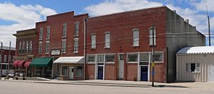
Downtown Table Rock: Houston Street
|
|

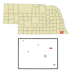
Location of Table Rock, Nebraska
|
|
| Country | United States |
| State | Nebraska |
| County | Pawnee |
| Area | |
| • Total | 0.59 sq mi (1.52 km2) |
| • Land | 0.59 sq mi (1.52 km2) |
| • Water | 0.00 sq mi (0.00 km2) |
| Elevation | 1,034 ft (315 m) |
| Population
(2020)
|
|
| • Total | 233 |
| • Estimate
(2021)
|
238 |
| • Density | 395/sq mi (153.3/km2) |
| Time zone | UTC-6 (Central (CST)) |
| • Summer (DST) | UTC-5 (CDT) |
| ZIP code |
68447
|
| Area code(s) | 402 |
| FIPS code | 31-48270 |
| GNIS feature ID | 2399947 |
Table Rock is a small village located in Pawnee County, Nebraska, in the United States. In 2020, about 236 people lived there.
Contents
A Look Back: Table Rock's History
Table Rock was officially planned and mapped out in 1855. It got its name from a big rock formation near the Nemaha River. Sadly, that rock formation is gone now.
The village didn't grow much at first. But around 1882, the Atchison and Nebraska Railroad was built through the town. This helped Table Rock to finally become a busy and successful place.
Where is Table Rock?
Table Rock is a village that covers about 0.59 square miles (1.52 square kilometers). All of this area is land, with no large bodies of water.
Table Rock's Climate and Weather
Table Rock has a climate known as a "hot-summer humid continental climate." This means it has warm, humid summers and cold winters.
The hottest temperature ever recorded in Table Rock was 106°F (41°C) on July 26, 2012. The coldest temperature recorded was -27°F (-33°C) on February 16–17, 2021.
| Climate data for Table Rock, Nebraska, 1991–2020 normals, extremes 1931–present | |||||||||||||
|---|---|---|---|---|---|---|---|---|---|---|---|---|---|
| Month | Jan | Feb | Mar | Apr | May | Jun | Jul | Aug | Sep | Oct | Nov | Dec | Year |
| Record high °F (°C) | 70 (21) |
79 (26) |
91 (33) |
92 (33) |
98 (37) |
100 (38) |
106 (41) |
103 (39) |
104 (40) |
98 (37) |
84 (29) |
74 (23) |
106 (41) |
| Mean maximum °F (°C) | 60.9 (16.1) |
63.2 (17.3) |
77.2 (25.1) |
86.0 (30.0) |
90.7 (32.6) |
94.7 (34.8) |
99.3 (37.4) |
98.5 (36.9) |
94.2 (34.6) |
87.3 (30.7) |
75.0 (23.9) |
61.9 (16.6) |
100.8 (38.2) |
| Mean daily maximum °F (°C) | 35.4 (1.9) |
40.7 (4.8) |
53.0 (11.7) |
63.8 (17.7) |
74.0 (23.3) |
83.7 (28.7) |
88.4 (31.3) |
86.6 (30.3) |
79.5 (26.4) |
67.1 (19.5) |
51.9 (11.1) |
39.4 (4.1) |
63.6 (17.6) |
| Daily mean °F (°C) | 24.9 (−3.9) |
29.4 (−1.4) |
40.6 (4.8) |
51.1 (10.6) |
62.0 (16.7) |
72.2 (22.3) |
76.7 (24.8) |
74.5 (23.6) |
66.3 (19.1) |
53.8 (12.1) |
40.3 (4.6) |
29.1 (−1.6) |
51.7 (11.0) |
| Mean daily minimum °F (°C) | 14.4 (−9.8) |
18.1 (−7.7) |
28.1 (−2.2) |
38.3 (3.5) |
50.0 (10.0) |
60.7 (15.9) |
65.0 (18.3) |
62.5 (16.9) |
53.1 (11.7) |
40.5 (4.7) |
28.6 (−1.9) |
18.8 (−7.3) |
39.8 (4.3) |
| Mean minimum °F (°C) | −7.5 (−21.9) |
−3.0 (−19.4) |
9.3 (−12.6) |
22.9 (−5.1) |
36.1 (2.3) |
49.2 (9.6) |
54.8 (12.7) |
51.2 (10.7) |
38.3 (3.5) |
24.5 (−4.2) |
12.8 (−10.7) |
−0.9 (−18.3) |
−10.6 (−23.7) |
| Record low °F (°C) | −17 (−27) |
−27 (−33) |
−8 (−22) |
12 (−11) |
27 (−3) |
38 (3) |
46 (8) |
43 (6) |
31 (−1) |
14 (−10) |
3 (−16) |
−15 (−26) |
−27 (−33) |
| Average precipitation inches (mm) | 0.78 (20) |
1.14 (29) |
2.18 (55) |
3.24 (82) |
5.01 (127) |
4.68 (119) |
4.56 (116) |
3.80 (97) |
3.13 (80) |
2.60 (66) |
1.69 (43) |
1.28 (33) |
34.09 (867) |
| Average snowfall inches (cm) | 5.6 (14) |
5.5 (14) |
2.6 (6.6) |
0.9 (2.3) |
0.0 (0.0) |
0.0 (0.0) |
0.0 (0.0) |
0.0 (0.0) |
0.0 (0.0) |
0.4 (1.0) |
1.7 (4.3) |
4.7 (12) |
21.4 (54.2) |
| Average precipitation days (≥ 0.01 in) | 4.6 | 5.0 | 7.1 | 9.6 | 10.6 | 9.5 | 9.1 | 8.2 | 7.0 | 7.3 | 5.3 | 4.6 | 87.9 |
| Average snowy days (≥ 0.1 in) | 2.8 | 2.9 | 1.5 | 0.4 | 0.0 | 0.0 | 0.0 | 0.0 | 0.0 | 0.1 | 1.0 | 2.3 | 11.0 |
| Source 1: NOAA | |||||||||||||
| Source 2: National Weather Service | |||||||||||||
People Living in Table Rock
| Historical population | |||
|---|---|---|---|
| Census | Pop. | %± | |
| 1890 | 673 | — | |
| 1900 | 852 | 26.6% | |
| 1910 | 814 | −4.5% | |
| 1920 | 750 | −7.9% | |
| 1930 | 673 | −10.3% | |
| 1940 | 562 | −16.5% | |
| 1950 | 513 | −8.7% | |
| 1960 | 422 | −17.7% | |
| 1970 | 429 | 1.7% | |
| 1980 | 393 | −8.4% | |
| 1990 | 308 | −21.6% | |
| 2000 | 264 | −14.3% | |
| 2010 | 269 | 1.9% | |
| 2020 | 233 | −13.4% | |
| 2021 (est.) | 238 | −11.5% | |
| U.S. Decennial Census | |||
Population in 2010
In 2010, the census counted 269 people living in Table Rock. There were 133 households, which are groups of people living together. About 70 of these were families.
The village had about 456 people per square mile. Most residents (97.8%) were White. A small number (1.5%) were African American. About 0.7% were from two or more racial backgrounds. Around 1.9% of the population identified as Hispanic or Latino.
Out of the 133 households, 27.1% had children under 18 living with them. Many households (40.6%) were married couples. Some households had a single parent, either a female householder (7.5%) or a male householder (4.5%). Nearly half (47.4%) were not families.
About 46.6% of all households had just one person living there. Also, 27.1% of households had someone aged 65 or older living alone. The average household had 2.02 people, and the average family had 2.83 people.
The average age of people in Table Rock was 46.3 years. About 23.4% of residents were under 18. About 24.5% were 65 years or older. The population was almost evenly split between males (49.1%) and females (50.9%).
Learning and Schools
Table Rock is part of the Humboldt Table Rock Steinauer Public Schools district. This school district also includes students from nearby towns like Steinauer, Humboldt, Dawson, Stella, and Shubert.
Famous People from Table Rock
- Rufus A. Lyman (1875–1957): He was a very important leader in pharmacy education in the United States during the early to mid-1900s.
- William R. (Link) Lyman (1898–1972): A famous football player who is in the Pro Football Hall of Fame.
- Theodore Pepoon (1836–1915): He was a lawmaker and also worked as a publisher.
- Floyd Vrtiska (1926–2020): A farmer who also became a politician.
See also
 In Spanish: Table Rock (Nebraska) para niños
 | Audre Lorde |
 | John Berry Meachum |
 | Ferdinand Lee Barnett |

