White Cloud, Kansas facts for kids
Quick facts for kids
White Cloud, Kansas
|
|
|---|---|

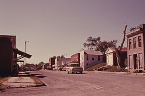
White Cloud (1974)
|
|

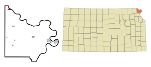
Location within Doniphan County and Kansas
|
|

|
|
| Country | United States |
| State | Kansas |
| County | Doniphan |
| Founded | 1855 |
| Platted | 1857 |
| Incorporated | 1862 |
| Named for | Francis White Cloud |
| Area | |
| • Total | 0.72 sq mi (1.88 km2) |
| • Land | 0.72 sq mi (1.88 km2) |
| • Water | 0.00 sq mi (0.00 km2) |
| Elevation | 879 ft (268 m) |
| Population
(2020)
|
|
| • Total | 115 |
| • Density | 159.7/sq mi (61.2/km2) |
| Time zone | UTC-6 (CST) |
| • Summer (DST) | UTC-5 (CDT) |
| ZIP code |
66094
|
| Area code | 785 |
| FIPS code | 20-77850 |
| GNIS ID | 2397301 |
White Cloud is a small city in Doniphan County, Kansas, United States. Its name comes from Francis White Cloud, who was the son of Chief White Cloud of the Iowa people. The name "White Cloud" in the Ioway language means "Village Cloud-White."
As of the 2020 census, about 115 people live in White Cloud. This city is also the main government center for the Iowa Tribe of Kansas and Nebraska.
Contents
History of White Cloud
The first post office in White Cloud opened in July 1855. This helped the town connect with other places.
Early Development and Growth
In 1857, two land developers, John Utt and Enoch Spaulding, bought the land where White Cloud is now. They started selling lots for homes and businesses. White Cloud grew quickly because it was located near the Missouri River. Steamboats traveling on the river brought many people and goods to the town.
Famous Moments and Filming Locations
In 1913, a ten-year-old boy named Wilbur Chapman from White Cloud became famous. He raised a pig and sold it for $25. He then gave all the money to the American Mission to Lepers, an organization that helped people with leprosy. A special monument was put in front of the Community Christian Church in White Cloud to honor Wilbur.
White Cloud has also been featured in movies and TV shows. Some parts of the 1973 movie Paper Moon were filmed here. Also, the town appeared in episode 4 of the 2008 TV show Stephen Fry in America.
Historic Places in White Cloud
Many important buildings in White Cloud are recognized for their history. The entire downtown area of White Cloud is listed on the National Register of Historic Places. This means it's a special place that helps tell the story of the past. The Poulet House and the White Cloud School are also listed as historic places.
Geography and Location
White Cloud is a small city, covering about 0.73 square miles (1.88 square kilometers). All of this area is land.
Population Changes Over Time
| Historical population | |||
|---|---|---|---|
| Census | Pop. | %± | |
| 1860 | 251 | — | |
| 1870 | 843 | 235.9% | |
| 1880 | 825 | −2.1% | |
| 1890 | 699 | −15.3% | |
| 1900 | 713 | 2.0% | |
| 1910 | 1,119 | 56.9% | |
| 1920 | 553 | −50.6% | |
| 1930 | 476 | −13.9% | |
| 1940 | 479 | 0.6% | |
| 1950 | 308 | −35.7% | |
| 1960 | 238 | −22.7% | |
| 1970 | 210 | −11.8% | |
| 1980 | 234 | 11.4% | |
| 1990 | 255 | 9.0% | |
| 2000 | 239 | −6.3% | |
| 2010 | 176 | −26.4% | |
| 2020 | 115 | −34.7% | |
| U.S. Decennial Census | |||
White Cloud is part of the larger St. Joseph, MO–KS Metropolitan Statistical Area. This means it's connected to the economy and community of the St. Joseph area.
White Cloud's Population in 2010
In 2010, there were 176 people living in White Cloud. These people lived in 86 households, and 44 of these were families. The city had about 241 people per square mile.
Most residents were White (68.2%), with 18.8% being Native American. About 5.1% of the population identified as Hispanic or Latino.
Education in White Cloud
Students in White Cloud attend schools in the Doniphan West USD 111 public school district.
Fun Places to Visit
White Cloud has a few interesting spots for visitors.
- Four State Lookout: This special viewing area is located on a high hill north of White Cloud. From here, you can see four different states: Kansas, Missouri, Nebraska, and Iowa!
- Casino White Cloud: About 5 miles west of the town, you'll find the Casino White Cloud. It's located on the Iowa Tribe Reservation.
See also

- In Spanish: White Cloud (Kansas) para niños
 | Tommie Smith |
 | Simone Manuel |
 | Shani Davis |
 | Simone Biles |
 | Alice Coachman |

