
National Register of Historic Places listings in Doniphan County, Kansas facts for kids

Have you ever wondered about old buildings and places that are super important to history? In Doniphan County, Kansas, there's a special list of these amazing spots called the National Register of Historic Places. It's like a hall of fame for buildings, areas, and even old archaeological sites that tell us a lot about the past of Kansas and the United States.
When a place is added to this list, it means it's recognized for its historical, architectural, or cultural importance. It helps protect these places so future generations can learn from them too! Doniphan County has 37 places on this list, and each one has a unique story. Some places were once on the list but have since been removed, perhaps because they changed too much or were no longer there.
Contents
What are Historic Places?
Historic places are buildings, structures, objects, sites, or districts that are important because of their connection to history. They might be old homes, churches, schools, bridges, or even places where important events happened.
Why are They Important?
These places help us understand how people lived long ago, what their communities were like, and how our country grew. They are like clues from the past that help us piece together the story of our world.
Cool Historic Spots in Doniphan County
Let's look at some of the interesting places in Doniphan County that are on the National Register of Historic Places. You'll find everything from old barns to courthouses and even ancient sites!
Historic Barns and Farms
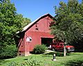
Many of the listings in Doniphan County are old barns. These barns tell us about the farming history of the area and how people used to live and work on farms. They are often built in special ways that show the building styles of their time.
- Albert Albers Barn: Located south of Bendena, this barn was listed in 1987. It's a great example of the farming heritage in the county.
- Nicholas Bohr Barn: Found southeast of Troy, this barn also joined the list in 1987.
- Herman Chrystal Barn: West of Wathena, this barn is another historic farm building from 1987.
- Mathew Eylar Barns (No. 1 & No. 2): These two barns, located near Denton, were both listed in 1987. They show how important farming was to the early settlers.
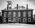
- George Kinkhead Barn: This barn, near Troy, was also listed in 1987. It's a good example of the architecture used for farm buildings back then.
Important Buildings and Districts
Beyond barns, Doniphan County has many other types of historic places, including important public buildings and entire areas that have kept their historical look and feel.
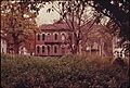
- Doniphan County Courthouse: Located in Troy, this beautiful courthouse was listed in 1974. It's the center of the county's government and a key part of its history.
- Doniphan County Courthouse Square Historic District: This area around the courthouse in Troy was listed in 2002. It includes many buildings that show what the town looked like long ago.
- First National Bank Building: In Highland, this old bank building from 2008 shows the economic history of the town.
- Highland Christian Church: Also in Highland, this church from 2007 is an important part of the community's religious history.
- Highland Presbyterian Church: Another historic church in Highland, listed in 2007, showing the growth of the town.
- Irvin Hall, Highland Community Junior College: This building on the Highland Community College campus was listed in 1971. It's a significant part of the area's educational history.
- Lincoln School, District 2: Located in Elwood, this school building from 2014 tells us about education in the early days.
- Poulet House: In White Cloud, this house from 1971 is a unique piece of residential history.
- St. Benedict's Church: Southwest of Bendena, this church from 1998 is an important religious landmark.
- St. Martha's AME Church and Parsonage: In Highland, this church and its parsonage (pastor's house) from 2000 are significant to the African American community's history.
- St. Mary's Catholic Church: Located in Purcell, this church from 2001 is another important religious site.
- Wathena Fruit Growers' Association Building: In Wathena, this building from 2009 shows the history of fruit farming and trade in the area.
- White Cloud Historic District: This large area in White Cloud was listed in 1996. It helps preserve the historic look and feel of the town.
- White Cloud School: This old school building in White Cloud was listed in 1973, showing the history of education there.
- A.L. Wynkoop House: In Highland, this house from 2007 is an example of historic homes in the area.
Archaeological Sites
Some listings are not buildings but important archaeological sites, which are places where scientists study the remains of past human life and activities. These sites are often kept secret to protect them.
- Doniphan Archeological Site: This site near Doniphan was listed in 1974.
- Fanning Archeological Site: Near Fanning, this site was listed in 1972.
Bridges and Other Structures
Even bridges can be historic! They show us how people traveled and built connections in the past.
- Doniphan County Waddell Truss Bridge: This bridge in Troy was listed in 1990. It's a special type of bridge design.
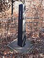
- Site No. RH00-062: This unique site, listed in 1987, extends into nearby counties and even another state!
Places No Longer Listed
Sometimes, a historic place might be removed from the National Register. This can happen if the building is changed too much, damaged, or even torn down. Five places in Doniphan County were once on the list but are not anymore.
- Dorland Building: This building in White Cloud was listed in 1978 but removed in 1986.
- Eclipse School: Near Troy, this school was listed in 1988 but delisted in 2004.
- Benjamin Harding House: In Wathena, this house was listed in 1977 but removed in 2004.
- Highland Water Tower: This water tower in Highland was listed in 2007 but delisted in 2015.
- Mission-Herring Barn: Near Highland, this barn was listed in 1987 but removed in 2004.
These historic places in Doniphan County are like treasures that help us remember and understand the past. They are important parts of our shared history!
Images for kids
-
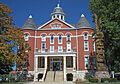
The Doniphan County Courthouse in Troy, Kansas.
-
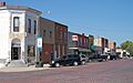
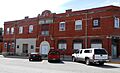
A view of Troy, Kansas, showing some of its historic buildings.
-
Irvin Hall at Highland Community College.
-
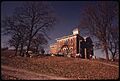
The front of the George Kinkhead Barn.
-
The Alexis Poulet House in White Cloud, Kansas.
-
A survey monument for Site No. RH00-062.
-
The Wathena Fruit Growers' Association Building.
-

Main Street in White Cloud, Kansas.
-
The White Cloud Schoolhouse.
-
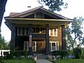
The A.L. Wynkoop House in Highland, Kansas.


