Nodaway River facts for kids
Quick facts for kids Nodaway River |
|
|---|---|

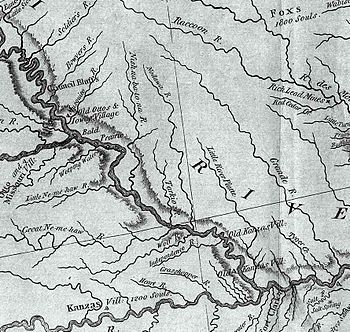
A section of the Lewis and Clark map of 1814 showing the rivers of northwest Missouri. The Nodaway is spelled "Nodawa".
|
|

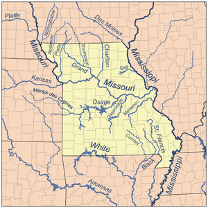
Map of northern Missouri rivers.
|
|
| Native name | Nodawa |
| Country | US |
| State | Iowa, Missouri |
| District | Page County, Iowa, Holt County, Missouri, Nodaway County, Missouri, Andrew County, Missouri |
| Physical characteristics | |
| Main source | Clarinda, Iowa, US 945 ft (288 m) 40°38′06″N 95°01′08″W / 40.635°N 95.019°W |
| River mouth | Missouri River Amazonia, Missouri, US 827 ft (252 m) 39°54′07″N 94°57′58″W / 39.902°N 94.966°W |
| Basin features | |
| Tributaries |
|

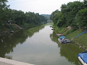
The Nodaway River is a 65.7-mile-long (105.7 km) river. It flows through southwest Iowa and northwest Missouri in the United States.
Contents
What's in a Name? The Nodaway River's Meaning
The name "Nodaway" first appeared as "Nodawa". It was written in the journal of the famous Lewis and Clark Expedition. They camped at the river's mouth on July 8, 1804. The name comes from the Otoe-Missouria language. It means "jump over water."
A River's Journey: History of the Nodaway
The Lewis and Clark Expedition explored this area. They camped at the river's mouth on Nodaway Island. This was near Nodaway, Missouri, in July 1804. They noted the river's location.
The river was important for early settlers. After the Platte Purchase in 1836, many people moved to northwest Missouri. The Nodaway River was a main route for them. Nodaway County was named after the river. It was a very large county in Missouri.
Exploring the Nodaway River System
The Nodaway River has several important smaller rivers and creeks that flow into it. These are called tributaries. Some of the main ones include the West Nodaway River and the East Nodaway River. Other creeks like Clear Creek and Elkhorn Creek also join in. The biggest town located along the river is Clarinda, Iowa.
Where the Nodaway River Begins
The Nodaway River officially starts near Shambaugh, Iowa. This is where the East and West Nodaway rivers meet.
- The West Nodaway River begins in eastern Cass County, Iowa. It flows south for about 73.8 miles (118.8 km). It passes towns like Villisca and Clarinda.
- The East Nodaway River starts in Adair County. It flows southwest for about 72.8 miles (117.2 km). It goes past Corning and Nodaway.
- The Middle Nodaway River also starts in Adair County. It flows southwest for about 60.5 miles (97.4 km). It joins the West Nodaway River near Villisca.
The East and West Nodaway rivers join together about 4 miles (6 km) north of the Iowa-Missouri border. From there, the main Nodaway River flows into Missouri near Clearmont, Missouri.
River Heights and Basin Size
The land around the Nodaway River changes in height. At the very start of the Middle Nodaway, it's about 1,400 feet (430 m) above sea level. Where the main Nodaway River begins, it's around 950 feet (290 m). By the time it reaches the Missouri River, it's about 800 feet (240 m) high.
The Nodaway River system covers a large area. This area, called its basin, is about 1,820 square miles (4,700 km2). This makes it a "sixth order" river, which means it's quite large and has many smaller streams feeding into it.
Neighboring Rivers and Flooding
The Nodaway River basin is surrounded by other river systems. To the east is the Platte River. To the northeast are the Grand River and Des Moines River. These rivers help define the boundary between the Missouri River and Mississippi River basins. To the west, you'll find the Tarkio River basin.
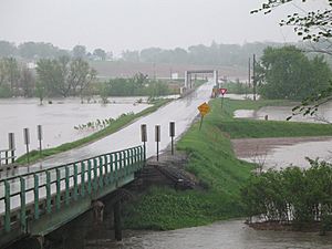
The Nodaway River basin can experience a lot of flooding. When there are big floods, the Nodaway River can add a lot of water to the Missouri River. Sometimes, it contributes as much as 20% of the flood crest near its mouth. For example, during the Great Flood of 1993, the river's flow at Graham, Missouri was huge. It went from a normal flow of about 1,011 cubic feet per second to 78,300 cubic feet per second!
 | James B. Knighten |
 | Azellia White |
 | Willa Brown |


