Ferrelview, Missouri facts for kids
Quick facts for kids
Ferrelview, Missouri
|
|
|---|---|
|
Village
|
|

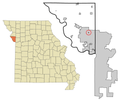
Location of Ferrelview, Missouri
|
|
| Country | United States |
| State | Missouri |
| County | Platte |
| Area | |
| • Total | 0.11 sq mi (0.29 km2) |
| • Land | 0.11 sq mi (0.29 km2) |
| • Water | 0.00 sq mi (0.00 km2) |
| Elevation | 948 ft (289 m) |
| Population
(2020)
|
|
| • Total | 642 |
| • Density | 5,783.78/sq mi (2,228.86/km2) |
| Time zone | UTC-6 (Central (CST)) |
| • Summer (DST) | UTC-5 (CDT) |
| ZIP code |
64163
|
| Area code(s) | 816 |
| FIPS code | 29-24058 |
| GNIS feature ID | 2398871 |
Ferrelview is a small village located in Platte County, Missouri, in the United States. It is part of the larger Kansas City metropolitan area. In 2010, the village had a population of 451 people. By the 2020 census, its population grew to 642 residents.
Contents
History of Ferrelview
How Ferrelview Got Its Name
The village of Ferrelview was named after a local land owner. Her name was Mollie Ferrel Heady. This is how the community got its unique name.
Early Post Office Services
A post office opened in Ferrelview in 1925. It operated independently until 1962. After that, it became a sub-contracted post office. It continued to offer full services to the community. This lasted until December 1981.
Geography of Ferrelview
Where is Ferrelview Located?
Ferrelview is a very small village. It is located in Platte County, Missouri. The entire village is surrounded by the much larger city of Kansas City. This means Kansas City completely encloses Ferrelview.
Land Area of the Village
According to the United States Census Bureau, Ferrelview covers a total area of about 0.11 square miles (0.29 square kilometers). All of this area is land. There are no large bodies of water within the village limits.
Population and People of Ferrelview
Population Changes Over Time
The population of Ferrelview has changed quite a bit over the years. Here is a look at how many people have lived there during different census years:
| Historical population | |||
|---|---|---|---|
| Census | Pop. | %± | |
| 1930 | 116 | — | |
| 1940 | 134 | 15.5% | |
| 1950 | 126 | −6.0% | |
| 1960 | 158 | 25.4% | |
| 1970 | 140 | −11.4% | |
| 1980 | 447 | 219.3% | |
| 1990 | 338 | −24.4% | |
| 2000 | 593 | 75.4% | |
| 2010 | 451 | −23.9% | |
| 2020 | 642 | 42.4% | |
| U.S. Decennial Census | |||
What the 2010 Census Showed
In 2010, the census counted 451 people living in Ferrelview. These people lived in 236 households. A household is a group of people living together. There were also 86 families.
The village had about 4,100 people per square mile. There were 300 housing units in total. Many households (55.5%) were made up of just one person. About 4.7% of households had someone living alone who was 65 or older.
The average household had about 1.91 people. The average family had about 3.02 people. The median age in the village was 39.1 years. This means half the people were younger than 39.1 and half were older.
- 19.1% of residents were under 18 years old.
- 10.1% were between 18 and 24 years old.
- 31.5% were between 25 and 44 years old.
- 30.9% were between 45 and 64 years old.
- 8.4% were 65 years or older.
More males lived in Ferrelview than females in 2010. About 56.3% of the population was male, and 43.7% was female.
See also
In Spanish: Ferrelview (Misuri) para niños
 | Valerie Thomas |
 | Frederick McKinley Jones |
 | George Edward Alcorn Jr. |
 | Thomas Mensah |

