Platte Woods, Missouri facts for kids
Quick facts for kids
Platte Woods, Missouri
|
|
|---|---|

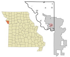
Location of Platte Woods, Missouri
|
|
| Country | United States |
| State | Missouri |
| County | Platte |
| Area | |
| • Total | 0.39 sq mi (1.01 km2) |
| • Land | 0.39 sq mi (1.01 km2) |
| • Water | 0.00 sq mi (0.00 km2) |
| Elevation | 1,024 ft (312 m) |
| Population
(2020)
|
|
| • Total | 394 |
| • Density | 1,010.26/sq mi (389.72/km2) |
| Time zone | UTC-6 (Central (CST)) |
| • Summer (DST) | UTC-5 (CDT) |
| ZIP code |
64151
|
| Area code(s) | 816 |
| FIPS code | 29-58196 |
| GNIS feature ID | 2396227 |
| Website | cityofplattewoods.org |
Platte Woods is a small city located in Platte County, Missouri. It is part of the larger Kansas City metropolitan area in the United States. In 2020, about 394 people lived in Platte Woods.
Contents
Platte Woods Geography
Platte Woods is a very small city. It covers about 0.39 square miles (1.01 square kilometers) of land. There are no lakes or rivers within the city limits.
Platte Woods Population History
The number of people living in Platte Woods has changed over the years. Here's a quick look at its population:
| Historical population | |||
|---|---|---|---|
| Census | Pop. | %± | |
| 1950 | 159 | — | |
| 1960 | 393 | 147.2% | |
| 1970 | 484 | 23.2% | |
| 1980 | 467 | −3.5% | |
| 1990 | 427 | −8.6% | |
| 2000 | 474 | 11.0% | |
| 2010 | 385 | −18.8% | |
| 2020 | 394 | 2.3% | |
| U.S. Decennial Census | |||
People in Platte Woods (2010)
In 2010, there were 385 people living in Platte Woods. These people lived in 163 homes. Most of the people (95.1%) were White. A small number were Asian (2.1%), African American (0.5%), or Native American (0.5%). About 3.6% of the population was Hispanic or Latino.
The average age of people in Platte Woods was about 49.8 years old.
- 19.7% of residents were under 18 years old.
- About 23.9% of residents were 65 years old or older.
- The city had a nearly equal number of males (49.6%) and females (50.4%).
See also
 In Spanish: Platte Woods para niños
 | May Edward Chinn |
 | Rebecca Cole |
 | Alexa Canady |
 | Dorothy Lavinia Brown |

