Platte City, Missouri facts for kids
Quick facts for kids
Platte City, Missouri
|
|
|---|---|

Location of Platte City, Missouri
|
|
| Country | United States |
| State | Missouri |
| County | Platte |
| Area | |
| • Total | 3.99 sq mi (10.33 km2) |
| • Land | 3.97 sq mi (10.27 km2) |
| • Water | 0.03 sq mi (0.06 km2) |
| Elevation | 968 ft (295 m) |
| Population
(2020)
|
|
| • Total | 4,784 |
| • Density | 1,206.25/sq mi (465.79/km2) |
| Time zone | UTC-6 (Central (CST)) |
| • Summer (DST) | UTC-5 (CDT) |
| ZIP code |
64079
|
| Area code(s) | 816 |
| FIPS code | 29-58178 |
| GNIS feature ID | 2396226 |
| Website | Platte City |
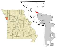
Platte City is a city in Platte County, Missouri, United States. It is the main city, also known as the county seat, of Platte County. In 2020, about 4,784 people lived here. Platte City is also part of the larger Kansas City metropolitan area.
Contents
Discovering Platte City's Past

Platte City was started by a person named Zadock "Zed" Martin. It officially became a city in September 1843.
Key Moments in Platte City's History
During the American Civil War, on December 16, 1861, Union soldiers led by Colonel W. James Morgan destroyed much of Platte City. This included the original courthouse.
Platte City is home to the oldest continuously running fair west of the Mississippi River. The Platte County Fair started way back in 1863 and happens every year just outside the city.
In 1882, the famous outlaw Jesse James had planned to rob the Platte City bank. However, the robbery never happened.
Years later, in 1933, another famous outlaw duo, Bonnie and Clyde, had a shootout with local police. This event happened just south of Platte City at a place called the Red Crown Tourist Court.
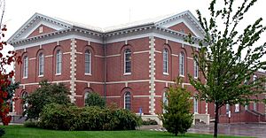
Two important buildings in Platte City are listed on the National Register of Historic Places. These are the Frederick Krause Mansion and the Platte County Courthouse.
Exploring Platte City's Location
Platte City is located right next to the south side of the Platte River. The Platte Falls Conservation Area is also nearby, to the northeast.
Major roads help people get to and from Platte City. I-29 runs along the east side of the city, and Missouri Route 92 also serves the area. The town of Tracy is located just north of the river.
According to the United States Census Bureau, Platte City covers a total area of about 3.65 square miles (9.45 square kilometers). Most of this area, about 3.61 square miles (9.35 square kilometers), is land. A small part, about 0.04 square miles (0.10 square kilometers), is water.
Understanding Platte City's Population
| Historical population | |||
|---|---|---|---|
| Census | Pop. | %± | |
| 1850 | 495 | — | |
| 1860 | 875 | 76.8% | |
| 1870 | 599 | −31.5% | |
| 1880 | 670 | 11.9% | |
| 1890 | 706 | 5.4% | |
| 1900 | 744 | 5.4% | |
| 1910 | 763 | 2.6% | |
| 1920 | 558 | −26.9% | |
| 1930 | 587 | 5.2% | |
| 1940 | 675 | 15.0% | |
| 1950 | 742 | 9.9% | |
| 1960 | 1,188 | 60.1% | |
| 1970 | 2,022 | 70.2% | |
| 1980 | 2,114 | 4.5% | |
| 1990 | 2,947 | 39.4% | |
| 2000 | 3,866 | 31.2% | |
| 2010 | 4,691 | 21.3% | |
| 2020 | 4,784 | 2.0% | |
| U.S. Decennial Census | |||
How Many People Live Here?
In 2010, the census showed that 4,691 people lived in Platte City. There were 1,975 households, which are like homes where people live. About 1,174 of these households were families.
The average age of people in Platte City was about 35.2 years old. About 24.2% of the residents were under 18 years old. Also, 11.6% of the people were 65 years old or older.
Learning in Platte City
The Platte County R-3 School District is in charge of schools in Platte City. This district runs three elementary schools and two middle schools. It also operates Platte County High School.
Platte City also has a public library. It is a branch of the Mid-Continent Public Library system. This means it's a great place for kids to find books and learn new things!
Getting Around Platte City
You can easily reach Platte City by using Interstate 29. The specific exit for Platte City is exit 18.
See also
 In Spanish: Platte City para niños
 | Claudette Colvin |
 | Myrlie Evers-Williams |
 | Alberta Odell Jones |

