Craig, Missouri facts for kids
Quick facts for kids
Craig, Missouri
|
|
|---|---|
 |
|

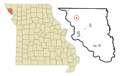
Location of Craig, Missouri
|
|
| Country | United States |
| State | Missouri |
| County | Holt |
| Township | Union |
| Area | |
| • Total | 0.26 sq mi (0.67 km2) |
| • Land | 0.26 sq mi (0.67 km2) |
| • Water | 0.00 sq mi (0.00 km2) |
| Elevation | 869 ft (265 m) |
| Population
(2020)
|
|
| • Total | 105 |
| • Density | 403.85/sq mi (156.22/km2) |
| Time zone | UTC-6 (Central (CST)) |
| • Summer (DST) | UTC-5 (CDT) |
| ZIP code |
64437
|
| Area code(s) | 660 |
| FIPS code | 29-17056 |
| GNIS feature ID | 2393661 |
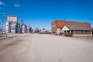
Craig is a small city located in the northwestern part of Holt County, Missouri, in the United States. According to the 2020 census, 105 people live there.
Contents
History of Craig, Missouri
Craig was first planned and built in 1868. The city was named after James Craig, who was a lawyer and an important politician in Missouri. A post office, also called Craig, started operating in 1869.
Geography of Craig
The city of Craig is located in a flat area near the Missouri River. This area is called a floodplain. The Burlington Northern Railroad tracks go right through the town. Craig is also very close to where two major roads meet: US Route 59 and Interstate 29.
Nearby towns include Corning, which is about 5.5 miles northwest. Mound City is 9 miles southeast. Fairfax, which is in a different county called Atchison County, is about 10 miles north.
The United States Census Bureau reports that Craig covers a total area of about 0.27 square miles (0.67 square kilometers). All of this area is land.
Population and People in Craig
| Historical population | |||
|---|---|---|---|
| Census | Pop. | %± | |
| 1880 | 541 | — | |
| 1890 | 503 | −7.0% | |
| 1900 | 775 | 54.1% | |
| 1910 | 621 | −19.9% | |
| 1920 | 642 | 3.4% | |
| 1930 | 626 | −2.5% | |
| 1940 | 718 | 14.7% | |
| 1950 | 578 | −19.5% | |
| 1960 | 488 | −15.6% | |
| 1970 | 369 | −24.4% | |
| 1980 | 379 | 2.7% | |
| 1990 | 346 | −8.7% | |
| 2000 | 309 | −10.7% | |
| 2010 | 248 | −19.7% | |
| 2020 | 105 | −57.7% | |
| U.S. Decennial Census | |||
Craig's Population in 2010
In 2010, the census showed that 248 people lived in Craig. There were 110 households, which means 110 different homes or groups of people living together. About 67 of these households were families.
The population density was about 918.5 people per square mile (354.6 people per square kilometer). This tells us how many people live in a certain amount of space.
Most of the people living in Craig in 2010 were White. A small number were Native American or from other races. About 0.8% of the population identified as Hispanic or Latino.
About 25.5% of the households had children under 18 years old living with them. The average household had about 2.25 people. The average family had about 2.81 people.
The median age of people in Craig was 47 years old. This means half the people were younger than 47, and half were older. About 18.1% of residents were under 18. About 19.4% were 65 years old or older. The city had a nearly even number of males and females.
See also
 In Spanish: Craig (Misuri) para niños
 | Bayard Rustin |
 | Jeannette Carter |
 | Jeremiah A. Brown |

