Carter Lake, Iowa facts for kids
Quick facts for kids
Carter Lake, Iowa
|
|
|---|---|

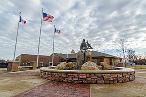
City Office Building in Carter Lake, Iowa
|
|

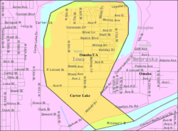
Location of Carter Lake, Iowa
|
|

U.S. Census Map
|
|
| Country | |
| State | |
| County | Pottawattamie |
| Government | |
| • Type | Mayor-council |
| Area | |
| • Total | 2.02 sq mi (5.23 km2) |
| • Land | 1.79 sq mi (4.65 km2) |
| • Water | 0.22 sq mi (0.58 km2) |
| Elevation | 974 ft (297 m) |
| Population
(2020)
|
|
| • Total | 3,791 |
| • Density | 2,113.15/sq mi (815.71/km2) |
| Time zone | UTC-6 (Central (CST)) |
| • Summer (DST) | UTC-5 (CDT) |
| ZIP code |
51510
|
| Area code(s) | 712 |
| FIPS code | 19-11215 |
| GNIS feature ID | 2393756 |
Carter Lake is a city in Pottawattamie County, Iowa, United States. It is a suburb of Omaha, Nebraska. The city is located around the south and west sides of Eppley Airfield, a major airport in the region.
What makes Carter Lake special is that it is separated from the rest of Iowa by the Missouri River. This means it is an exclave, which is a part of a country or state that is geographically separated from the main part. In 2020, about 3,791 people lived in Carter Lake.
Contents
History of Carter Lake
Carter Lake is a unique example of how state borders can be a bit unusual in the United States. It is the only city in Iowa that is located west of the Missouri River.
How Carter Lake Was Formed
In March 1877, a big flood changed the path of the Missouri River. The river moved about 2 kilometers (1.25 miles) to the southeast. The old path of the river, called Saratoga Bend, became a U-shaped lake known as an oxbow lake. This lake was named Carter Lake.
Soon after the lake formed, the area became a popular spot for fun activities. People enjoyed boating and fishing. There were boathouses, hotels, and clubhouses around the lake.
Border Disputes and Court Rulings
For many years, there was a disagreement between Iowa and Nebraska about which state Carter Lake belonged to. In 1892, the Supreme Court of the United States made a decision. They ruled that Carter Lake was part of Iowa.
Usually, state borders along a river follow the river's gradual changes. However, the Court said there's an exception when a river suddenly changes its course, like in a flood. This sudden change is called an avulsion. In 1972, the Supreme Court made another ruling about the border between the two states, confirming Carter Lake's status.
Becoming an Independent City
Even though Carter Lake was legally part of Council Bluffs, its residents faced a problem. They paid city taxes but did not get the same city services as people living east of the Missouri River.
In the 1920s, the community decided to separate from Council Bluffs. They hoped to join Omaha, Nebraska. However, Omaha did not want to pay for new sewer and water lines for the area. So, on July 2, 1930, Carter Lake officially became its own city in Iowa.
Amusement Parks and Entertainment
Carter Lake was once home to two early amusement parks. The Courtland Beach Amusement Park operated from 1905 to 1917. Then, from 1917 to 1933, the Lakeview Amusement Park entertained visitors. The Munchoff Brothers, who also ran Krug Park in Omaha, managed both parks. In 1917, they even moved rides from Courtland to Lakeview. Later, in 1945, one of the brothers donated the old park rides to help with metal drives during World War II.
Geography of Carter Lake
The city of Carter Lake is surrounded on three sides by Omaha, Nebraska. On the fourth side, it borders the Missouri River.
According to the United States Census Bureau, the city covers a total area of about 5.23 square kilometers (2.02 square miles). Most of this area, about 4.65 square kilometers (1.79 square miles), is land. The rest, about 0.58 square kilometers (0.22 square miles), is water.
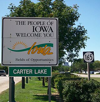
Carter Lake creates a bit of a puzzle for people traveling to Eppley Airfield. The airport is surrounded by Carter Lake on its south and west sides. This means that if you are going to Eppley Airfield from almost anywhere in Omaha (except North Omaha), you will pass through Carter Lake, Iowa. It can be confusing for travelers who see a "Welcome to Iowa" sign on their way to or from the airport!
Population and People
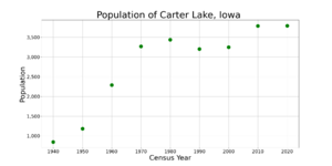
| Historical populations | ||
|---|---|---|
| Year | Pop. | ±% |
| 1940 | 846 | — |
| 1950 | 1,183 | +39.8% |
| 1960 | 2,287 | +93.3% |
| 1970 | 3,268 | +42.9% |
| 1980 | 3,438 | +5.2% |
| 1990 | 3,200 | −6.9% |
| 2000 | 3,248 | +1.5% |
| 2010 | 3,785 | +16.5% |
| 2020 | 3,791 | +0.2% |
| Source: and Iowa Data Center Source: |
||
Population in 2010
Based on the census from 2010, there were 3,785 people living in Carter Lake. These people lived in 1,388 households, and 997 of these were families. The city had about 2,024 people per square mile (781 people per square kilometer).
Most of the people in Carter Lake were White (90.3%). Other groups included African American (1.0%), Native American (0.8%), and Asian (0.5%). About 11.5% of the population was Hispanic or Latino.
Households and Families
Out of the 1,388 households, 37.4% had children under 18 living there. About 46.5% were married couples living together. Some households had a female head with no husband (17.9%) or a male head with no wife (7.4%). About 22.3% of all households were individuals living alone.
The average household had 2.73 people, and the average family had 3.16 people. The median age in the city was 36.1 years. About 28.3% of residents were under 18 years old.
See also
 In Spanish: Carter Lake (Iowa) para niños
 | Audre Lorde |
 | John Berry Meachum |
 | Ferdinand Lee Barnett |


