Treynor, Iowa facts for kids
Quick facts for kids
Treynor (Iowa)
|
|
|---|---|

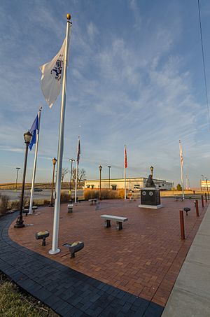
Treynor, Iowa Memorial
|
|

Location of Treynor in Iowa
|
|
| Country | |
| State | |
| County | Pottawattamie |
| Government | |
| • Type | City Council |
| Area | |
| • Total | 0.65 sq mi (1.67 km2) |
| • Land | 0.65 sq mi (1.67 km2) |
| • Water | 0.00 sq mi (0.00 km2) |
| Elevation | 1,240 ft (380 m) |
| Population
(2020)
|
|
| • Total | 1,032 |
| • Density | 1,600.00/sq mi (617.95/km2) |
| Time zone | UTC-6 (Central (CST)) |
| • Summer (DST) | UTC-5 (CDT) |
| ZIP code |
51575
|
| Area code(s) | 712 |
| FIPS code | 19-78825 |
| GNIS feature ID | 2397051 |
Treynor is a small city located in Pottawattamie County, Iowa, in the United States. In 2020, about 1,032 people lived there. It's a quiet place with a rich history.
Contents
History of Treynor
Treynor started in the late 1880s, east of Council Bluffs. Early settlers included Fritz Eyberg, who opened a general store. August Olderog had a dance hall and saloon. A church called St. Paul's German Evangelical Church was also built.
Early Names and Post Office
Before it was called Treynor, the area was known for its many wolves. Local German farmers sometimes called it Four Corners or High Five. The name Treynor came about when a post office opened in the early 1890s. It was named after the postmaster from Council Bluffs who had recently passed away.
Growth and Railroad
By 1905, Treynor officially became a town. It had several businesses, including two general stores, two saloons, and a bank. In 1911, a railroad line called the Iowa & Omaha Shortline opened. This line connected Treynor to a larger railroad, but it only lasted five years because it wasn't making enough money.
Challenges and Changes
The Great Depression in the 1930s caused the Treynor State Bank to close. However, improvements began on the road connecting Treynor to Council Bluffs. This road is now known as Iowa Highway 92. Later, during the early years of the Cold War, an Air Force radar base operated near the town.
Geography of Treynor
Treynor is a small city that covers an area of about 0.65 square miles (1.67 square kilometers). All of this area is land, with no large bodies of water within the city limits.
People of Treynor
The number of people living in Treynor has changed over the years. Here's a look at how the population has grown:
| Historical populations | ||
|---|---|---|
| Year | Pop. | ±% |
| 1910 | 122 | — |
| 1920 | 204 | +67.2% |
| 1930 | 232 | +13.7% |
| 1940 | 219 | −5.6% |
| 1950 | 247 | +12.8% |
| 1960 | 368 | +49.0% |
| 1970 | 472 | +28.3% |
| 1980 | 981 | +107.8% |
| 1990 | 897 | −8.6% |
| 2000 | 950 | +5.9% |
| 2010 | 919 | −3.3% |
| 2020 | 1,032 | +12.3% |
| Source: and Iowa Data Center Source: |
||
Population in 2020
In 2020, the city of Treynor had 1,032 residents. There were 394 households, and 295 of these were families. Most people living in Treynor were White. A small percentage of the population identified as Hispanic or Latino.
Many households in Treynor had children under 18 living with them. The average age of people in Treynor was about 38 years old. About 30% of the residents were under 20 years old, and nearly 18% were 65 or older. The population was slightly more female than male.
Population in 2010
Back in 2010, Treynor had 919 people. There were 363 households. Most residents were White.
About 35.8% of households had children under 18. The average age was 40.7 years. Around 26.4% of residents were under 18, and 15.3% were 65 or older. The number of males and females was almost equal.
Education in Treynor
The Treynor Community School District provides education for students in Treynor and the areas around it.
See also
 In Spanish: Treynor (Iowa) para niños
 | Stephanie Wilson |
 | Charles Bolden |
 | Ronald McNair |
 | Frederick D. Gregory |

