Shelby, Iowa facts for kids
Quick facts for kids
Shelby, Iowa
|
|
|---|---|

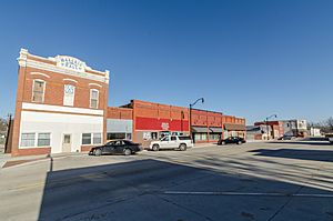
Downtown Shelby, Iowa
|
|

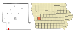
Location of Shelby, Iowa
|
|
| Country | |
| State | |
| Counties | Shelby, Pottawattamie |
| Area | |
| • Total | 1.87 sq mi (4.85 km2) |
| • Land | 1.87 sq mi (4.85 km2) |
| • Water | 0.00 sq mi (0.00 km2) |
| Elevation | 1,345 ft (410 m) |
| Population
(2020)
|
|
| • Total | 727 |
| • Density | 387.94/sq mi (149.78/km2) |
| Time zone | UTC-6 (Central (CST)) |
| • Summer (DST) | UTC-5 (CDT) |
| ZIP code |
51570
|
| Area code(s) | 712 |
| FIPS code | 19-72300 |
| GNIS feature ID | 2395863 |
| Website | City of Shelby |
Shelby is a small city located in the state of Iowa, USA. It's special because it sits in two different counties: Pottawattamie and Shelby counties. In 2020, about 727 people lived there.
Contents
Discovering Shelby's Past
Shelby began to grow in the late 1860s. This happened when a railroad line was built through the area.
How Shelby Was Founded
The city of Shelby was officially planned in 1870. Benjamin F. Allen and Thusie Allen were the people who laid out the city's design. Shelby became an official city in 1877.
Historic Railroad Landmark
North-east of Shelby, there's an old stone arch bridge. It was built for the Chicago, Rock Island, and Pacific Railroad. This bridge is so important that it's listed on the National Register of Historic Places.
Shelby's Location and Size
Shelby is located at 41°30′51″N 95°27′0″W / 41.51417°N 95.45000°W. This means it's in the western part of Iowa.
The city covers a total area of about 1.74 square miles (4.51 square kilometers). All of this area is land, with no large bodies of water inside the city limits.
Shelby's Population Over Time
| Historical populations | ||
|---|---|---|
| Year | Pop. | ±% |
| 1880 | 449 | — |
| 1890 | 582 | +29.6% |
| 1900 | 692 | +18.9% |
| 1910 | 586 | −15.3% |
| 1920 | 588 | +0.3% |
| 1930 | 617 | +4.9% |
| 1940 | 627 | +1.6% |
| 1950 | 592 | −5.6% |
| 1960 | 533 | −10.0% |
| 1970 | 537 | +0.8% |
| 1980 | 665 | +23.8% |
| 1990 | 637 | −4.2% |
| 2000 | 696 | +9.3% |
| 2010 | 641 | −7.9% |
| 2020 | 727 | +13.4% |
| Source: and Iowa Data Center Source: |
||
The population of Shelby changes over the years. The table above shows how many people have lived in Shelby since 1880.
Shelby's Population in 2020
In 2020, the census counted 727 people living in Shelby. There were 296 households, which are groups of people living together. The city had about 388 people per square mile.
Most of the people in Shelby were White (93.0%). About 27% of the residents were under 20 years old. The average age in Shelby was about 35.4 years.
Shelby's Population in 2010
Back in 2010, there were 641 people living in Shelby. There were 263 households. The population density was about 368 people per square mile.
Most residents were White (98.6%). About 22.6% of the people were under 18 years old. The average age was 40.8 years.
Shelby's Time Capsule
Shelby has a special time capsule! It was sealed on July 16, 1970. This was part of the city's 100th birthday celebration.
Opening the Time Capsule
The "Centennial Time Capsule" was supposed to be opened on July 16, 2020. However, it was delayed because of the COVID-19 pandemic. It was finally opened on Friday, June 25, 2021. You can find the time capsule in Shelby Park. It's near the corner of Center Street and West Street.
Education in Shelby
Students in Shelby attend schools in the AHSTW Community School District. This district serves several communities.
School District Changes
Before 1996, Shelby had its own school district. On July 1, 1996, the Shelby Community School District joined with another district. This created the A-H-S-T Community School District. Then, on July 1, 2016, that district merged again. It became the AHSTW Community School District, which is what it is today.
See also
 In Spanish: Shelby (Iowa) para niños
 | May Edward Chinn |
 | Rebecca Cole |
 | Alexa Canady |
 | Dorothy Lavinia Brown |

