
National Register of Historic Places listings in Shelby County, Iowa facts for kids

Have you ever wondered about old buildings or places that have a special story? In Shelby County, Iowa, there are many such places! These special spots are listed on something called the National Register of Historic Places. It's like a national list of important buildings, areas, or structures that are worth protecting because of their history.
When a place is added to this list, it means it's recognized for its unique past, its cool architecture, or its connection to important events or people. It helps everyone remember and appreciate the stories these places can tell us. In Shelby County, there are 13 different places that have earned a spot on this important list!
Contents
What is the National Register of Historic Places?
The National Register of Historic Places is the official list of the United States' historic places that are worth saving. It's part of a national program to coordinate and support public and private efforts to identify, evaluate, and protect America's historic and archaeological resources. Think of it as a Hall of Fame for buildings and sites!
When a place is listed, it doesn't mean it becomes a museum, but it does get special recognition. This can help with getting grants for repairs or protecting it from being torn down. It's all about making sure these pieces of history last for future generations.
Historic Places in Shelby County
Shelby County is home to several fascinating historic sites. Each one tells a different part of the county's story, from old schools to grand churches and important farmsteads.
Old Buildings and Structures
Many of the places on the list are buildings that show how people lived and worked a long time ago.
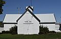
Floral Hall in Harlan
The Floral Hall in Harlan is a cool building located on the Shelby County Fairgrounds. It was added to the list in 1985. Imagine all the fairs and events that have happened there over the years! It's a reminder of community gatherings and traditions.
Irwin Consolidated School
The Irwin Consolidated School in Irwin became a historic place in 2002. Schools are super important to a community, and this one has seen many students learn and grow. It represents the history of education in the area.
Shelby Consolidated School
Another school on the list is the Shelby Consolidated School in Shelby, added in 2014. Just like the Irwin school, it shows how important schools were and still are to small towns.
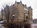
Shelby County Courthouse
The Shelby County Courthouse in Harlan was listed in 1978. Courthouses are often grand buildings where important decisions are made and laws are upheld. This building is a symbol of local government and justice in the county.
Historic Districts
Sometimes, it's not just one building that's important, but a whole group of buildings or an area. These are called historic districts.
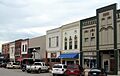
Harlan Courthouse Square Commercial District
The Harlan Courthouse Square Commercial District was added to the list in 1994. This district includes the area around the courthouse in Harlan. It's special because it shows what a town center looked like and how businesses operated in the past. Walking through it is like taking a step back in time!
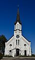
Saint Boniface Catholic Church District
In Westphalia, the Saint Boniface Catholic Church District became historic in 1991. This district likely includes the church and other buildings around it, showing the importance of the church to the community's history and daily life.
Other Notable Sites
There are also other unique places that tell different stories.
Chicago, Rock Island and Pacific Railroad Stone Arch Viaduct
Near Shelby, you can find the Chicago, Rock Island and Pacific Railroad Stone Arch Viaduct. This old railroad bridge was listed in 1998. It's a great example of old engineering and reminds us how important railroads were for travel and moving goods across the country.
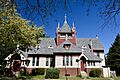
St. Paul's Episcopal Church
The St. Paul's Episcopal Church in Harlan was recognized in 1978. Churches often serve as central points in communities, and this one has been a place of worship and gathering for many years.
Historic Farmsteads and Houses
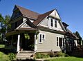
Several old homes and farmsteads are also on the list, showing the history of farming and family life in Shelby County. These include the Jens Otto Christiansen House, Chris Larsen House, Chris Poldberg Farmstead, George Rewerts House, and the Pleasant View Stock Farm Historic District. Each one has its own story about the people who lived there and how they shaped the land.
Former Listings
Sometimes, a place might be removed from the National Register. This can happen if a building is destroyed or if its historical importance changes. One example from Shelby County is the J.C. Heese Lumber Shed in Earling, which was listed in 1991 but later removed in 1997.
Images for kids
-
Floral Hall in Harlan
-
Harlan Courthouse Square Commercial District
-

Irwin Consolidated School
-
George Rewerts House
-
Saint Boniface Catholic Church in Westphalia
-
St. Paul's Episcopal Church in Harlan
-
Shelby County Courthouse


.jpg)
.jpg)

