Hartington, Nebraska facts for kids
Quick facts for kids
Hartington, Nebraska
|
|
|---|---|

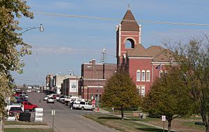
Downtown Hartington; Cedar County Courthouse in right foreground
|
|

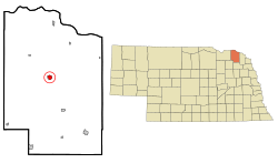
Location of Hartington, Nebraska
|
|
| Country | United States |
| State | Nebraska |
| County | Cedar |
| Area | |
| • Total | 1.02 sq mi (2.63 km2) |
| • Land | 1.02 sq mi (2.63 km2) |
| • Water | 0.00 sq mi (0.00 km2) |
| Elevation | 1,414 ft (431 m) |
| Population
(2020)
|
|
| • Total | 1,514 |
| • Estimate
(2021)
|
1,506 |
| • Density | 1,493.11/sq mi (576.47/km2) |
| Time zone | UTC-6 (Central (CST)) |
| • Summer (DST) | UTC-5 (CDT) |
| ZIP code |
68739
|
| Area code(s) | 402 |
| FIPS code | 31-21275 |
| GNIS feature ID | 2394310 |
Hartington is a small city located in Cedar County, Nebraska, in the United States. About 1,514 people lived there according to the 2020 census. It's a friendly place with a rich history and interesting buildings.
Contents
Exploring Hartington's Past
Hartington was officially planned and laid out in 1883. It started as a "water stop" for trains on the railroad. This meant trains would stop there to refill their water tanks. The city was named after Lord Hartington, a famous person from England who had recently visited the U.S.
Historic Buildings to See
Hartington has several old and important buildings. Three of these are made of brick and are listed on the National Register of Historic Places. This means they are special and protected because of their history.
- The Hartington City Hall and Auditorium was built between 1921 and 1923. It shows a style called Prairie School architecture.
- The Cedar County Courthouse was built in 1890-1891. It features the Romanesque Revival style, which looks like old Roman buildings.
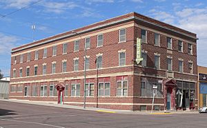
- The Hartington Hotel was built in 1917. It has a Colonial Revival style, which reminds people of early American homes.
Hartington's Location and Landscape
Hartington covers an area of about 1.02 square miles (2.63 square kilometers). All of this area is land. The city is served by two main roads, Nebraska State Highways 57 and 84. These highways help people travel in and out of the city.
Understanding Hartington's Climate
Hartington experiences a wide range of temperatures throughout the year. On July 17, 1936, the city recorded the highest temperature ever in Nebraska. It reached a scorching 118 degrees Fahrenheit (48 degrees Celsius)! This record is shared with two other Nebraska cities, Minden and Geneva.
| Climate data for Hartington, Nebraska (1991–2020, extremes 1893–present) | |||||||||||||
|---|---|---|---|---|---|---|---|---|---|---|---|---|---|
| Month | Jan | Feb | Mar | Apr | May | Jun | Jul | Aug | Sep | Oct | Nov | Dec | Year |
| Record high °F (°C) | 74 (23) |
76 (24) |
92 (33) |
102 (39) |
108 (42) |
109 (43) |
118 (48) |
111 (44) |
105 (41) |
97 (36) |
82 (28) |
72 (22) |
118 (48) |
| Mean maximum °F (°C) | 55.4 (13.0) |
59.8 (15.4) |
73.4 (23.0) |
83.3 (28.5) |
88.9 (31.6) |
93.9 (34.4) |
94.9 (34.9) |
93.8 (34.3) |
90.7 (32.6) |
85.7 (29.8) |
70.6 (21.4) |
55.7 (13.2) |
96.9 (36.1) |
| Mean daily maximum °F (°C) | 30.3 (−0.9) |
34.8 (1.6) |
47.1 (8.4) |
59.2 (15.1) |
70.4 (21.3) |
80.3 (26.8) |
84.8 (29.3) |
82.4 (28.0) |
76.0 (24.4) |
62.5 (16.9) |
46.8 (8.2) |
33.6 (0.9) |
59.0 (15.0) |
| Daily mean °F (°C) | 20.2 (−6.6) |
24.1 (−4.4) |
35.4 (1.9) |
47.1 (8.4) |
59.1 (15.1) |
69.6 (20.9) |
74.0 (23.3) |
71.4 (21.9) |
63.5 (17.5) |
50.1 (10.1) |
35.7 (2.1) |
24.0 (−4.4) |
47.9 (8.8) |
| Mean daily minimum °F (°C) | 10.1 (−12.2) |
13.3 (−10.4) |
23.7 (−4.6) |
35.0 (1.7) |
47.8 (8.8) |
59.0 (15.0) |
63.2 (17.3) |
60.4 (15.8) |
51.0 (10.6) |
37.7 (3.2) |
24.6 (−4.1) |
14.3 (−9.8) |
36.7 (2.6) |
| Mean minimum °F (°C) | −10.4 (−23.6) |
−6.2 (−21.2) |
4.0 (−15.6) |
20.8 (−6.2) |
33.7 (0.9) |
46.7 (8.2) |
51.2 (10.7) |
49.3 (9.6) |
34.7 (1.5) |
22.1 (−5.5) |
7.0 (−13.9) |
−6.6 (−21.4) |
−14.8 (−26.0) |
| Record low °F (°C) | −38 (−39) |
−33 (−36) |
−17 (−27) |
1 (−17) |
19 (−7) |
35 (2) |
38 (3) |
35 (2) |
20 (−7) |
5 (−15) |
−17 (−27) |
−33 (−36) |
−38 (−39) |
| Average precipitation inches (mm) | 0.57 (14) |
0.84 (21) |
1.50 (38) |
3.21 (82) |
4.37 (111) |
4.64 (118) |
3.46 (88) |
3.34 (85) |
3.01 (76) |
2.56 (65) |
1.30 (33) |
0.79 (20) |
29.59 (752) |
| Average snowfall inches (cm) | 8.1 (21) |
6.7 (17) |
6.2 (16) |
4.0 (10) |
0.0 (0.0) |
0.0 (0.0) |
0.0 (0.0) |
0.0 (0.0) |
0.0 (0.0) |
0.9 (2.3) |
4.6 (12) |
4.8 (12) |
35.3 (90) |
| Average precipitation days (≥ 0.01 in) | 3.9 | 4.3 | 5.1 | 8.6 | 10.0 | 8.9 | 7.2 | 7.0 | 6.1 | 5.6 | 4.0 | 4.0 | 74.7 |
| Average snowy days (≥ 0.1 in) | 4.6 | 3.7 | 3.0 | 1.2 | 0.0 | 0.0 | 0.0 | 0.0 | 0.0 | 0.4 | 2.2 | 3.9 | 19.0 |
| Source: NOAA | |||||||||||||
People of Hartington
| Historical population | |||
|---|---|---|---|
| Census | Pop. | %± | |
| 1900 | 971 | — | |
| 1910 | 1,413 | 45.5% | |
| 1920 | 1,467 | 3.8% | |
| 1930 | 1,568 | 6.9% | |
| 1940 | 1,688 | 7.7% | |
| 1950 | 1,660 | −1.7% | |
| 1960 | 1,648 | −0.7% | |
| 1970 | 1,581 | −4.1% | |
| 1980 | 1,730 | 9.4% | |
| 1990 | 1,583 | −8.5% | |
| 2000 | 1,640 | 3.6% | |
| 2010 | 1,554 | −5.2% | |
| 2020 | 1,514 | −2.6% | |
| U.S. Decennial Census | |||
How Many People Live Here?
In 2010, there were 1,554 people living in Hartington. These people lived in 641 households, and 402 of these were families. The city had about 1,653 people per square mile.
Many types of people live in Hartington. Most residents were White (99.2%). A small number were from other backgrounds. About 0.5% of the people were Hispanic or Latino.
Families and Age Groups
In 2010, about 28.4% of households had children under 18 living there. More than half (56.5%) of households were married couples. About 37.3% of households were not families.
The average age of people in Hartington was 42.6 years old.
- About 26.1% of residents were under 18.
- About 6.1% were between 18 and 24 years old.
- About 19.7% were between 25 and 44 years old.
- About 21.9% were between 45 and 64 years old.
- About 26.2% were 65 or older.
The city had a nearly equal number of males (49.8%) and females (50.2%).
Famous People from Hartington
Hartington has been home to several notable individuals who achieved success in various fields.
- Ralph G. Brooks was the 29th Governor of Nebraska.
- Dwight W. Burney also served as the 30th Governor of Nebraska.
- Willard H. Burney was a member of the Nebraska House of Representatives.
- Russ Hochstein played American football as a guard for the Kansas City Chiefs.
- James Lee Rankin was the United States Solicitor General from 1956 to 1961.
- Charles Thone was a U.S. Representative and later served as the governor of Nebraska.
See also
 In Spanish: Hartington (Nebraska) para niños
 | John T. Biggers |
 | Thomas Blackshear |
 | Mark Bradford |
 | Beverly Buchanan |


