Lewis and Clark Lake facts for kids
Quick facts for kids Lewis and Clark Lake |
|
|---|---|
| Location | |
| Coordinates | 42°51′45″N 97°29′30″W / 42.8625°N 97.4917°W |
| Type | reservoir (artificial lake; man-made lake) |
| Primary inflows | Missouri River, Niobrara River |
| Primary outflows | Missouri River |
| Catchment area | 16,000 sq mi (41,000 km2) |
| Basin countries | United States |
| Max. length | 25 miles (40 km) |
| Max. width | 1.8 miles (2.9 km) at dam |
| Surface area | 31,400 acres (12,700 ha) |
| Average depth | 15–30 ft (4.6–9.1 m) |
| Max. depth | 45 ft (14 m) |
| Water volume | 492,000 acre⋅ft (0.607 km3) |
| Shore length1 | 90 mi (140 km) |
| Surface elevation | 1,206–1,210 ft (368–369 m) msl |
| Settlements | Yankton, SD Springfield, SD Running Water, SD Santee, NE Niobrara, NE |
| 1 Shore length is not a well-defined measure. | |
Lewis and Clark Lake is a large, man-made lake on the border of Nebraska and South Dakota. It is part of the Missouri River. The lake was created by the Gavins Point Dam.
This lake is about 25 miles (40 km) long. It has over 90 miles (140 km) of shoreline. The deepest part of the lake is about 45 feet (14 m). The United States Army Corps of Engineers manages the lake.
Contents
History of Lewis and Clark Lake
The area around Lewis and Clark Lake has a rich history. Many early Native American tribes, pioneers, and settlers lived here. They used the river for travel and found many resources.
The lake is named after the famous explorers Meriwether Lewis and William Clark. They traveled through this area on their journey to the Pacific Ocean. The lake is located along the Lewis and Clark National Historic Trail.
Early People and Tribes
People have lived in this area for a very long time. Archaeological records show people lived here around 3,000 to 5,000 B.C. These early people lived near small streams that flowed into the Missouri River Valley.
Later, from 500 B.C. to 1,000 A.D., people from the Woodland period lived here. More recently, in the late 1700s and 1800s, the Ponca, Yankton Sioux, and Omaha tribes lived in the area. The Santee Sioux arrived in the mid-1800s and still live nearby.
In 1804, Lewis and Clark met with the Yankton Sioux tribe. This important meeting happened below Calumet Bluff. It was their first time meeting a Sioux tribe on their journey up the river.
Bon Homme Colony and Dam Construction
In 1874, the Bon Homme Colony settled on what is now the north shore of the lake. These people are Hutterites, a group related to the Mennonites. They were exiled from Austria. This was the first Hutterite Colony in South Dakota and the United States. They still live a traditional, shared way of life.
Lewis and Clark Lake was filled in 1957. This happened after the Gavins Point Dam was finished. The dam was built across the river valley.
Location of the Lake
Lewis and Clark Lake is a reservoir on the Missouri River. It is about 811 miles (1,305 km) upstream from St. Louis, Missouri. In St. Louis, the Missouri River joins the Mississippi River.
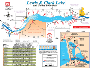
The lake is located in Cedar and Knox Counties in Nebraska. It is also in Bon Homme and Yankton Counties in South Dakota. Lake Yankton is just below the Gavins Point Dam.
The Santee Sioux Reservation is along the southwestern shore of the lake. The lake is about 4 miles (6.4 km) west of Yankton, South Dakota.
Lewis and Clark Visitor Center
The Lewis and Clark Visitor Center is a great place to learn about the area. It is located just south of Gavins Point Dam. From here, you can see amazing views of Lewis and Clark Lake, Lake Yankton, and the Missouri River.
The visitor center is open every day during summer. It is open on weekdays during other times of the year. You can learn about the history of the Missouri River Basin. This includes Native Americans, pioneers, and the Lewis and Clark Expedition. You can also learn about local wildlife and the history of the U.S. Army Corps of Engineers.
A theater at the center shows educational videos. These videos are about the Lewis and Clark Expedition, how the dam was built, and the natural history of the Missouri River. There is also a bookstore.
The visitor center is famous for its views of American Bald Eagles. These majestic birds often visit the Missouri River below the dam, especially in winter. Park Rangers from the U.S. Army Corps of Engineers run the center. They also give guided tours of Gavins Point Dam and the power plant.
Parks and Recreation
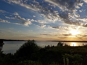
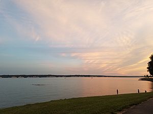
Lewis and Clark Lake is a very popular place for fun activities in the Midwest. Many people come here for camping, water sports, hiking, bird watching, hunting, fishing, swimming, and biking. More than one million people visit the lake area each year.
Many recreation areas around the lake have boat ramps, marinas, campgrounds, and day-use areas. The upper parts of the lake are great for seeing and hunting waterfowl. This is because the lake is on a major bird flyway.
Downstream from the lake is the Missouri National Recreational River (MNRR). This section is 59 miles (95 km) long. It goes from the dam to Ponca State Park. Upstream from the lake, another part of the MNRR is 39 miles (63 km) long. It stretches to Fort Randall Dam.
List of Recreation and Public Use Areas
Here are some of the public parks and lake access areas on Lewis and Clark Lake:
- Nebraska:
- Lewis and Clark State Recreation Area (NE GPC)
- Weigand-Burbach Area & Marina
- South Shore Recreation Area
- Bloomfield Recreation Area
- Miller Creek Recreation Area
- Niobrara State Park (NE GPC)
- Niobrara Recreation Area (Village of Niobrara)
- Calumet Bluff Trail & Overlook (USACE)
- Hideaway Acres (Hideaway Acres Assn.)
- Santee Recreation Area (USACE & Santee Sioux Nation)
- Cottonwood Recreation Area (USACE)
- Nebraska Tailwaters Recreation Area (USACE)
- Training Dike Recreation Area (USACE)
- Deep Water Area (USACE)
- Devil's Nest (USACE)
- Bazile Creek Wildlife Management Area (NE GPC)
- Lewis and Clark State Recreation Area (NE GPC)
- South Dakota:
- Lewis & Clark Recreation Area (SD GFP)
- Lewis & Clark Marina and Resort
- Pierson Ranch Recreation Area
- Chief White Crane Recreation Area
- Gavins Point National Fish Hatchery and Aquarium (U.S. Fish & Wildlife Service)
- Tabor Lakeside Use Area (SD GFP)
- Charley Creek Lakeside Use Area (SD GFP)
- Twin Bridges Lakeside Use Area (SD GFP)
- Sand Creek Lakeside Use Area (SD GFP)
- Springfield Recreation Area (SD GFP)
- Springfield Bottoms Game Production Area (SD GFP)
- Running Water Lakeside Use Area (SD GFP)
- Lewis & Clark Recreation Area (SD GFP)
- Key:
- NE GPC = Nebraska Game and Parks Commission
- USACE = U.S. Army Corps of Engineers
- SD GFP = South Dakota Department of Game, Fish and Parks
Fish, Wildlife, and Natural Resources
The natural resources and public lands around the lake are managed together. This is done by the U.S. Army Corps of Engineers, the Nebraska Game and Parks Commission, and the South Dakota Department of Game, Fish, and Parks.
Animals and Birds
Common game animals found around the lake include White-tailed deer, Wild Turkey, many types of waterfowl, Pheasant, Cottontail rabbit, Mourning Doves, and squirrels. The American Bald Eagle is often seen around the dam and lake. They are especially common in the winter months. Every January, the Lewis and Clark Visitor Center hosts "Bald Eagle Days." This is a popular event with live bird programs.
Fish Species
Many kinds of fish live in the lake. These include walleye, northern pike, sauger, sunfish, yellow perch, common carp, black bullhead, channel catfish, and smallmouth bass. Fishing below Gavins Point Dam is very popular. People especially enjoy the annual paddlefish snagging season in October and bowfishing in June. The "Fishing Wall" just below the dam's spillway is a popular spot for fishing all year. The dam keeps the river from freezing in winter.
Protecting Species
The U.S. Army Corps of Engineers and the U.S. Fish and Wildlife Service work to protect endangered species on the lake and river. Some species they are concerned about include the Pallid sturgeon, least tern, and piping plover. The Missouri River Recovery Program helps to bring back natural habitats. These habitats were lost when the dam was built and the river was changed. The Gavins Point National Fish Hatchery is located just downstream of the lake.
Current Lake Issues
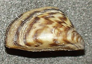
There are a few issues affecting the lake. In 2014, zebra mussels were found in the lake. These are an aquatic invasive mussel. They have spread throughout the lake and the Missouri River below the dam.
Lewis and Clark Lake is also affected by sedimentation. This means that sediment (like sand and mud) is building up in the lake. The Missouri River and Niobrara River carry this sediment. When the water slows down in the lake because of the dam, the sediment settles.
Studies show that about 5.1 million tons of sediment are deposited in the lake each year. This is making the lake's water surface area smaller. It also reduces how much water the lake can hold. About 60% of the sediment comes from the Nebraska Sandhills through the Niobrara River.
As of 2016, about 30% of the lake's total surface area had shrunk due to this sediment. Some experts think that by 2045, about 50% of the lake will be smaller. Right now, there is no plan to remove the silt or slow its buildup in the lake.
 | Jackie Robinson |
 | Jack Johnson |
 | Althea Gibson |
 | Arthur Ashe |
 | Muhammad Ali |


