Douglas County, South Dakota facts for kids
Quick facts for kids
Douglas County
|
|
|---|---|

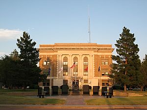
Douglas County Courthouse in Armour
|
|

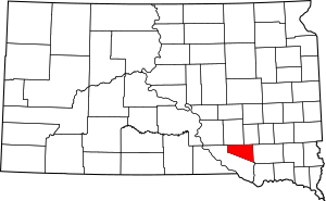
Location within the U.S. state of South Dakota
|
|
 South Dakota's location within the U.S. |
|
| Country | |
| State | |
| Founded | 1873 (created) 1882 (organized) |
| Named for | Stephen A. Douglas |
| Seat | Armour |
| Largest city | Armour |
| Area | |
| • Total | 434 sq mi (1,120 km2) |
| • Land | 432 sq mi (1,120 km2) |
| • Water | 1.9 sq mi (5 km2) 0.4% |
| Population
(2020)
|
|
| • Total | 2,835 |
| • Estimate
(2023)
|
2,838 |
| • Density | 6.532/sq mi (2.522/km2) |
| Congressional district | At-large |
Douglas County is a county in the state of South Dakota. A county is like a smaller region within a state. As of 2020, about 2,835 people lived there. The main town, or county seat, is Armour.
Douglas County was created in 1873 and officially set up in 1882. It is named after Stephen Douglas, a famous political figure from Illinois.
Contents
Exploring Douglas County
Douglas County is known for its gently rolling hills. Most of the land is used for farming. The highest point in the county is about 1,677 feet (511 meters) above sea level. This is near the southwestern edge of the county. The land generally slopes downwards towards the east.
The county covers a total area of 434 square miles (1,124 square kilometers). Most of this is land, with only a small part being water. Douglas County is actually the second-smallest county in South Dakota by its total area.
Main Roads in the County
You can travel through Douglas County using several important roads:
Neighboring Counties
Douglas County shares its borders with these other counties:
- Aurora County to the north
- Davison County to the northeast
- Hutchinson County to the east
- Charles Mix County to the southwest
Lakes You Can Find
- Corsica Lake
People of Douglas County
The number of people living in Douglas County has changed over the years.
| Historical population | |||
|---|---|---|---|
| Census | Pop. | %± | |
| 1890 | 4,600 | — | |
| 1900 | 5,012 | 9.0% | |
| 1910 | 6,400 | 27.7% | |
| 1920 | 6,993 | 9.3% | |
| 1930 | 7,236 | 3.5% | |
| 1940 | 6,348 | −12.3% | |
| 1950 | 5,636 | −11.2% | |
| 1960 | 5,113 | −9.3% | |
| 1970 | 4,569 | −10.6% | |
| 1980 | 4,181 | −8.5% | |
| 1990 | 3,746 | −10.4% | |
| 2000 | 3,458 | −7.7% | |
| 2010 | 3,002 | −13.2% | |
| 2020 | 2,835 | −5.6% | |
| 2023 (est.) | 2,838 | −5.5% | |
| U.S. Decennial Census 1790-1960 1900-1990 1990-2000 2010-2020 |
|||
What the 2020 Census Showed
In 2020, the census counted 2,835 people living in Douglas County. There were 1,134 households, which are groups of people living together. About 779 of these were families. The county had about 6.6 people per square mile.
A Look at the 2010 Census
Back in 2010, there were 3,002 people in the county. Most people were white (96.6%). About 1.8% were American Indian. A small number of people were from other backgrounds. Many families in Douglas County have Dutch or German roots.
The average age of people in the county was about 48 years old. The typical income for a family was around $53,750 per year.
Towns and Places
Douglas County has several communities where people live.
Cities in Douglas County
Special Census Places
These are areas that are like towns but are counted separately for the census:
- Greenwood Colony
- Harrison
- New Holland
Other Communities
- Joubert is a small, unincorporated community. This means it doesn't have its own local government.
Townships in the County
Douglas County is divided into smaller areas called townships:
- Belmont
- Chester
- Clark
- East Choleau
- Garfield
- Grandview
- Holland
- Independence
- Iowa
- Joubert
- Lincoln
- Valley
- Walnut Grove
- Washington
Old Ghost Towns
Some places that used to be towns in Douglas County are now "ghost towns." This means people no longer live there.
- Douglas City
- Flensburg
- Grand View
- Huston
- Maitland
See also
 In Spanish: Condado de Douglas (Dakota del Sur) para niños
 | Kyle Baker |
 | Joseph Yoakum |
 | Laura Wheeler Waring |
 | Henry Ossawa Tanner |

