Platte, South Dakota facts for kids
Quick facts for kids
Platte, South Dakota
|
|
|---|---|

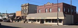
Main Street in Platte, February 2016
|
|

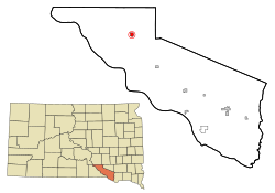
Location in Charles Mix County and the state of South Dakota
|
|
| Country | United States |
| State | South Dakota |
| County | Charles Mix |
| Incorporated | 1907 |
| Area | |
| • Total | 1.05 sq mi (2.73 km2) |
| • Land | 1.05 sq mi (2.73 km2) |
| • Water | 0.00 sq mi (0.00 km2) |
| Elevation | 1,601 ft (488 m) |
| Population
(2020)
|
|
| • Total | 1,296 |
| • Density | 1,230.77/sq mi (475.39/km2) |
| Time zone | UTC−6 (Central (CST)) |
| • Summer (DST) | UTC−5 (CDT) |
| ZIP code |
57369
|
| Area code(s) | 605 |
| FIPS code | 46-50260 |
| GNIS feature ID | 1267535 |
| Website | http://www.plattesd.org/ |
Platte is a city located in Charles Mix County, South Dakota, in the United States. In 2022, about 1,311 people lived there. The city is named after Platte Creek. This creek is a branch of the Missouri River that flows into Lake Francis Case. Platte is about 15 miles east of Lake Francis Case.
Contents
History of Platte
Early explorers Lewis and Clark were told about "burning bluffs" in this area. People started settling here in the early 1880s. A fur trader named Bernard Pratte once lived near the mouth of what was then called "Fish Creek." On an old map, his last name was accidentally written as Platte. This spelling mistake stuck, and the creek became known as Platte Creek. The town that grew up nearby was then named after the creek.
For 12 years, Charles Mix County was the only county in South Dakota without a railroad. This changed in the summer of 1900. Platte was chosen as the end point for a new railroad line. This line came from Yankton and was part of the Chicago, Milwaukee, and St. Paul company.
The railroad arrived in October 1900. Many buildings were moved from nearby settlements like Castalia, Old Platte, and Edgerton to the new town of Platte. The local newspaper, the Platte Enterprise, started in 1900 and is still printed today.
The 1930s brought tough times with the Great Depression and a long period of dry weather called a drought. Many people lost their jobs and moved away. During this time, a dam was built on Platte Creek. This area then became a popular spot for picnics and fun outdoor activities.
Later, in 1956, the Fort Randall Dam was finished. This created the large Lake Francis Case. In 1966, the Platte-Winner Bridge was built over the lake. This bridge gave travelers a new way to get to and from the Black Hills.
Geography and Climate
Platte's Location and Size
According to the United States Census Bureau, the city of Platte covers a total area of about 1.02 square miles (2.64 square kilometers). All of this area is land. The city is located where two main roads meet: Highway 44 and Highway 45.
Platte's Weather Patterns
Platte has a type of weather known as a humid continental climate. This means it has big differences in temperature between seasons. Summers are warm to hot and often humid. Winters are cold, and sometimes very cold. The Köppen Climate Classification system calls this "Dfa."
| Climate data for Platte, South Dakota | |||||||||||||
|---|---|---|---|---|---|---|---|---|---|---|---|---|---|
| Month | Jan | Feb | Mar | Apr | May | Jun | Jul | Aug | Sep | Oct | Nov | Dec | Year |
| Mean daily maximum °C (°F) | −1 (31) |
2 (35) |
8 (46) |
16 (60) |
22 (72) |
27 (81) |
32 (89) |
31 (87) |
26 (78) |
18 (65) |
8 (47) |
1 (34) |
16 (60) |
| Mean daily minimum °C (°F) | −13 (8) |
−11 (12) |
−6 (22) |
2 (35) |
7 (45) |
13 (56) |
16 (61) |
15 (59) |
9 (49) |
3 (37) |
−4 (24) |
−11 (13) |
2 (35) |
| Average precipitation mm (inches) | 13 (0.5) |
15 (0.6) |
33 (1.3) |
64 (2.5) |
84 (3.3) |
97 (3.8) |
69 (2.7) |
64 (2.5) |
48 (1.9) |
38 (1.5) |
20 (0.8) |
13 (0.5) |
550 (21.8) |
| Source: Weatherbase | |||||||||||||
People of Platte: Demographics
| Historical population | |||
|---|---|---|---|
| Census | Pop. | %± | |
| 1910 | 1,115 | — | |
| 1920 | 1,242 | 11.4% | |
| 1930 | 1,207 | −2.8% | |
| 1940 | 1,017 | −15.7% | |
| 1950 | 1,069 | 5.1% | |
| 1960 | 1,167 | 9.2% | |
| 1970 | 1,351 | 15.8% | |
| 1980 | 1,334 | −1.3% | |
| 1990 | 1,311 | −1.7% | |
| 2000 | 1,367 | 4.3% | |
| 2010 | 1,230 | −10.0% | |
| 2020 | 1,296 | 5.4% | |
| U.S. Decennial Census 2018 Estimate |
|||
Understanding the 2010 Census Data
The census is a count of people. In 2010, there were 1,230 people living in Platte. These people lived in 548 households, and 337 of these were families. The population density was about 1,206 people per square mile (466 people per square kilometer). There were 625 homes available.
Most people in Platte (98.5%) were White. A small number (0.6%) were Native American. About 0.9% were from two or more racial backgrounds. Very few people (0.1%) were Hispanic or Latino.
Out of the 548 households:
- 23.0% had children under 18 living there.
- 56.6% were married couples living together.
- 3.5% had a female head of the house with no husband.
- 1.5% had a male head of the house with no wife.
- 38.5% were not families (like single people living alone).
The average household had 2.16 people. The average family had 2.80 people.
The median age in the city was 48.6 years old. This means half the people were younger and half were older than 48.6.
- 20.4% of residents were under 18.
- 6.3% were between 18 and 24.
- 19% were between 25 and 44.
- 25.9% were between 45 and 64.
- 28.4% were 65 or older.
The city had slightly more females (51.6%) than males (48.4%).
See also
 In Spanish: Platte (Dakota del Sur) para niños
 | Charles R. Drew |
 | Benjamin Banneker |
 | Jane C. Wright |
 | Roger Arliner Young |

