Kennebec, South Dakota facts for kids
Quick facts for kids
Kennebec, South Dakota
|
|
|---|---|

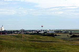
Panorama of Kennebec
|
|

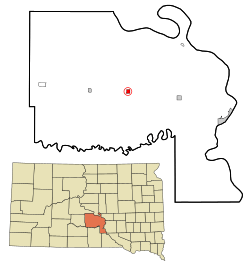
Location in Lyman County and the state of South Dakota
|
|
| Country | United States |
| State | South Dakota |
| County | Lyman |
| Incorporated | 1909 |
| Area | |
| • Total | 0.85 sq mi (2.21 km2) |
| • Land | 0.85 sq mi (2.21 km2) |
| • Water | 0.00 sq mi (0.00 km2) |
| Elevation | 1,690 ft (520 m) |
| Population
(2020)
|
|
| • Total | 281 |
| • Density | 329.43/sq mi (127.18/km2) |
| Time zone | UTC-6 (Central (CST)) |
| • Summer (DST) | UTC-5 (CDT) |
| ZIP code |
57544
|
| Area code(s) | 605 |
| FIPS code | 46-33580 |
| GNIS feature ID | 1267443 |
Kennebec is a small town in South Dakota, United States. It is the main town, or county seat, for Lyman County, South Dakota. In 2020, about 281 people lived there.
Contents
History of Kennebec
Kennebec was first started in 1905. It became the county seat of Lyman County in 1922. This means it's where the county government offices are located. The building where the county government works, called the courthouse, was built in 1925.
Getting Around Kennebec
The main way to travel to and from Kennebec is by road. Two important highways are close by. Interstate 90 (I-90) runs east and west. South Dakota Highway 273 (SD 273) runs north and south.
There isn't an airport in Kennebec for people to fly in or out. Also, there are no passenger trains. However, the Ringneck and Western Railroad does provide freight service. This means they carry goods, like grain, for local businesses.
Geography and Location
Kennebec is a town that covers about 0.85 square miles (2.21 square kilometers) of land. It's located in an area mostly used for farming.
The town is about 25 miles (40 km) west-northwest of Chamberlain. It's also about 42 miles (68 km) east of Murdo. Larger cities like Mitchell are about 89 miles (143 km) east. Rapid City is about 180 miles (290 km) to the east. A small stream called Medicine Creek is just south of Kennebec.
Kennebec's Climate and Weather
Kennebec experiences a variety of weather throughout the year. Here's a look at the average temperatures and rainfall:
| Climate data for Kennebec, South Dakota (1991−2020 normals, extremes 1893−present) | |||||||||||||
|---|---|---|---|---|---|---|---|---|---|---|---|---|---|
| Month | Jan | Feb | Mar | Apr | May | Jun | Jul | Aug | Sep | Oct | Nov | Dec | Year |
| Record high °F (°C) | 70 (21) |
76 (24) |
91 (33) |
99 (37) |
108 (42) |
112 (44) |
119 (48) |
114 (46) |
110 (43) |
101 (38) |
89 (32) |
74 (23) |
119 (48) |
| Mean daily maximum °F (°C) | 31.6 (−0.2) |
36.4 (2.4) |
49.0 (9.4) |
61.6 (16.4) |
72.4 (22.4) |
82.4 (28.0) |
89.7 (32.1) |
87.8 (31.0) |
80.3 (26.8) |
63.8 (17.7) |
47.1 (8.4) |
34.3 (1.3) |
61.4 (16.3) |
| Daily mean °F (°C) | 20.4 (−6.4) |
24.6 (−4.1) |
35.9 (2.2) |
47.3 (8.5) |
58.6 (14.8) |
69.0 (20.6) |
75.6 (24.2) |
73.5 (23.1) |
64.9 (18.3) |
49.7 (9.8) |
34.7 (1.5) |
23.4 (−4.8) |
48.1 (8.9) |
| Mean daily minimum °F (°C) | 9.2 (−12.7) |
12.7 (−10.7) |
22.7 (−5.2) |
32.9 (0.5) |
44.9 (7.2) |
55.6 (13.1) |
61.4 (16.3) |
59.2 (15.1) |
49.5 (9.7) |
35.6 (2.0) |
22.3 (−5.4) |
12.5 (−10.8) |
34.9 (1.6) |
| Record low °F (°C) | −42 (−41) |
−45 (−43) |
−28 (−33) |
−7 (−22) |
11 (−12) |
28 (−2) |
35 (2) |
32 (0) |
11 (−12) |
−19 (−28) |
−23 (−31) |
−35 (−37) |
−45 (−43) |
| Average precipitation inches (mm) | 0.45 (11) |
0.59 (15) |
0.96 (24) |
2.34 (59) |
3.29 (84) |
3.48 (88) |
2.84 (72) |
2.31 (59) |
1.72 (44) |
1.63 (41) |
0.71 (18) |
0.47 (12) |
20.79 (528) |
| Average snowfall inches (cm) | 5.5 (14) |
7.6 (19) |
5.5 (14) |
6.2 (16) |
0.0 (0.0) |
0.0 (0.0) |
0.0 (0.0) |
0.0 (0.0) |
0.0 (0.0) |
1.6 (4.1) |
6.0 (15) |
7.2 (18) |
39.6 (101) |
| Average precipitation days (≥ 0.01 in) | 4.3 | 4.9 | 5.0 | 8.7 | 9.8 | 10.0 | 8.0 | 7.2 | 6.3 | 6.6 | 4.5 | 4.5 | 79.8 |
| Average snowy days (≥ 0.1 in) | 3.1 | 4.0 | 2.6 | 1.6 | 0.0 | 0.0 | 0.0 | 0.0 | 0.0 | 0.6 | 2.4 | 3.7 | 18.0 |
| Source: NOAA | |||||||||||||
Population of Kennebec
The number of people living in Kennebec has changed over the years. Here's how the population has grown and shrunk since 1910:
| Historical population | |||
|---|---|---|---|
| Census | Pop. | %± | |
| 1910 | 252 | — | |
| 1920 | 341 | 35.3% | |
| 1930 | 349 | 2.3% | |
| 1940 | 390 | 11.7% | |
| 1950 | 374 | −4.1% | |
| 1960 | 372 | −0.5% | |
| 1970 | 372 | 0.0% | |
| 1980 | 334 | −10.2% | |
| 1990 | 284 | −15.0% | |
| 2000 | 286 | 0.7% | |
| 2010 | 240 | −16.1% | |
| 2020 | 281 | 17.1% | |
| U.S. Decennial Census | |||
Population in 2010
In 2010, there were 240 people living in Kennebec. They lived in 112 homes, and 69 of these were families. The town had about 282 people per square mile.
Most of the people in Kennebec were White (90%). About 6.7% were Native American. A small number (3.3%) were from two or more racial backgrounds.
The average age of people in Kennebec was about 45.6 years old. About 22.5% of residents were under 18. About 26.3% were 65 years old or older. The town had slightly more males (51.7%) than females (48.3%).
Famous People from Kennebec
Some notable people have connections to Kennebec:
- James Abdnor – He was a politician from South Dakota. He served as a United States Senator from 1981 to 1987.
- James Schaefer – He was a politician in South Dakota's state government. He was also a rancher.
- Merrill Q. Sharpe – He served as the Governor of South Dakota.
See also
 In Spanish: Kennebec (Dakota del Sur) para niños
 | Precious Adams |
 | Lauren Anderson |
 | Janet Collins |


