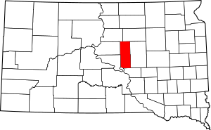
Hyde County, South Dakota facts for kids
Quick facts for kids
Hyde County
|
|
|---|---|

Location within the U.S. state of South Dakota
|
|
 South Dakota's location within the U.S. |
|
| Country | |
| State | |
| Founded | 1883 |
| Named for | James Hyde |
| Seat | Highmore |
| Largest city | Highmore |
| Area | |
| • Total | 866 sq mi (2,240 km2) |
| • Land | 861 sq mi (2,230 km2) |
| • Water | 5.6 sq mi (15 km2) 0.6% |
| Population
(2020)
|
|
| • Total | 1,262 |
| • Estimate
(2023)
|
1,186 |
| • Density | 1.4573/sq mi (0.5627/km2) |
| Time zone | UTC−6 (Central) |
| • Summer (DST) | UTC−5 (CDT) |
| Congressional district | At-large |
Hyde County is a place in South Dakota, a state in the United States. In 2020, about 1,262 people lived here. This makes it one of the smallest counties in South Dakota by population. The main town, or county seat, is Highmore.
Hyde County started in 1873 when it was part of the Dakota Territory. It officially began operating in 1883. It's named after James Hyde, who was a lawmaker in the 1870s.
Contents
History of Hyde County
Hyde County was first created on January 8, 1873. It was formed from a part of Buffalo County. The county's borders changed a few times. On November 5, 1883, Hyde County officially started working on its own.
The building where the county government works, called the courthouse, was built in 1911. It's now a historic place! The county used to have its own jail until 1974. After that, other nearby counties helped with jail services.
Geography and Nature
Hyde County has rolling hills that are somewhat dry. Some of this land is used for farming. The Missouri River flows along the southwest part of the county.
The land gently slopes down towards the southwest corner. The highest point in the county is about 2,080 feet (634 meters) above sea level.
Hyde County covers about 866 square miles (2,243 square kilometers). Most of this area, 861 square miles (2,230 square kilometers), is land. The rest, about 5.6 square miles (14.5 square kilometers), is water.
Main Roads
These are the important roads that go through Hyde County:
Neighboring Counties
Hyde County shares borders with these other counties:
- Faulk County - to the north
- Hand County - to the east
- Buffalo County - to the south
- Lyman County - to the southwest
- Hughes County - to the southwest
- Sully County - to the west
- Potter County - to the northwest
Protected Natural Areas
These are special areas in Hyde County that protect wildlife and nature:
- Chapelle State Game Production Area
- Highmore State Game Production Area
- Rezac Lake State Game Production Area
- Rice Lake State Game Production Area
Lakes in Hyde County
You can find these lakes in Hyde County:
- Baloun Lake
- Chapelle Lake
- Lake Boehm
- Rezac Lake
- Rice Lake
- Thomas Lake
Population and People
| Historical population | |||
|---|---|---|---|
| Census | Pop. | %± | |
| 1890 | 1,860 | — | |
| 1900 | 1,492 | −19.8% | |
| 1910 | 3,307 | 121.6% | |
| 1920 | 3,315 | 0.2% | |
| 1930 | 3,690 | 11.3% | |
| 1940 | 3,113 | −15.6% | |
| 1950 | 2,811 | −9.7% | |
| 1960 | 2,602 | −7.4% | |
| 1970 | 2,515 | −3.3% | |
| 1980 | 2,069 | −17.7% | |
| 1990 | 1,696 | −18.0% | |
| 2000 | 1,671 | −1.5% | |
| 2010 | 1,420 | −15.0% | |
| 2020 | 1,262 | −11.1% | |
| 2023 (est.) | 1,186 | −16.5% | |
| U.S. Decennial Census 1790-1960 1900-1990 1990-2000 2010-2020 |
|||
Every ten years, the United States counts its population. This is called a census.
2020 Census Information
In 2020, the census showed that 1,262 people lived in Hyde County. There were 522 households, which are groups of people living together. About 355 of these were families. On average, there were about 1.5 people living in each square mile. There were also 626 housing units, like houses or apartments.
2010 Census Information
In 2010, there were 1,420 people living in the county. There were 600 households and 385 families. The population density was about 1.7 people per square mile.
Most people in Hyde County were white (89.1%). About 8.5% were American Indian. A small number of people were from other backgrounds. About 1.1% of the population was of Hispanic or Latino origin.
The average age of people in Hyde County was about 46.4 years old.
Towns and Areas
City
- Highmore (This is the county seat, the main town.)
Census-designated place
Townships
- Banner
- Bramhall
- Douglas
- Eden
- Franklin
- Holabird
- Highmore
- Illinois
- Lincoln
- Loomis
- Spring Lake
- Union
- Valley
- William Hamilton
Unorganized territories
These are areas that are not part of a city or township:
- Central Hyde
- Crow Creek
- North Hyde
See also
 In Spanish: Condado de Hyde (Dakota del Sur) para niños
 | Claudette Colvin |
 | Myrlie Evers-Williams |
 | Alberta Odell Jones |

