Williams County, North Dakota facts for kids
Quick facts for kids
Williams County
|
|
|---|---|

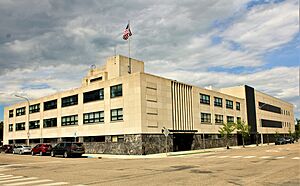
Williams County Courthouse
|
|

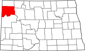
Location within the U.S. state of North Dakota
|
|
 North Dakota's location within the U.S. |
|
| Country | |
| State | |
| Founded | 1891 |
| Named for | Erastus Appleman Williams |
| Seat | Williston |
| Largest city | Williston |
| Area | |
| • Total | 2,148 sq mi (5,560 km2) |
| • Land | 2,077 sq mi (5,380 km2) |
| • Water | 70 sq mi (200 km2) 3.3% |
| Population
(2020)
|
|
| • Total | 40,950 |
| • Estimate
(2023)
|
39,113 |
| • Density | 19.064/sq mi (7.3607/km2) |
| Time zone | UTC−6 (Central) |
| • Summer (DST) | UTC−5 (CDT) |
| Congressional district | At-large |
Williams County is found on the western edge of North Dakota, right next to Montana. In 2020, about 40,950 people lived here. This makes it the fifth most populated county in North Dakota. The main town and county center is Williston.
The upper Missouri River forms the southern border of the county. The Yellowstone River joins the Missouri River just east of the Montana border.
Contents
History of Williams County
There have actually been two places called Williams County in North Dakota's past!
The First Williams County
The first Williams County was created in 1873. It was located south of the Missouri River. This county existed even when North Dakota became a state.
However, in 1892, people voted to get rid of this first county. Part of its land became part of Mercer County, and the rest became unorganized territory.
The Second Williams County
The Williams County we know today was created by the North Dakota state government on March 2, 1891. It was formed from two older areas called Buford and Flannery, which were then closed down.
The county's government officially started on December 8, 1891. In 1910, some of its land was used to create Divide County. The borders of Williams County have stayed the same ever since.
The county is named after Erastus Appleman Williams. He was an important person who served in the government of the Dakota Territory and later in North Dakota.
Geography and Nature
Williams County is on the western side of North Dakota. Its western border touches the state of Montana. The Missouri River flows along the county's southern edge. The Yellowstone River meets the Missouri River near the Montana border.
The land in Williams County has rolling hills and some flat areas. Parts of the county are used for farming. The highest point in the county is a hill near the northeast corner, which is about 2,470 feet (753 meters) above sea level.
The county covers about 2,148 square miles (5,563 square kilometers). Most of this is land, and about 70 square miles (181 square kilometers) is water. This makes it the fourth-largest county in North Dakota by size.
Lake Sakakawea, a large lake on the Missouri River, is on the southern border of the county. The Fort Union Trading Post National Historic Site is also in Williams County, along the Missouri River near the Montana border.
Williams County is also known for being part of the Bakken formation. This is an important area for oil and gas in western North Dakota.
Main Roads
- U.S. Highway 2
- U.S. Highway 85
- U.S. Highway 85B
- North Dakota Highway 40
- North Dakota Highway 42
- North Dakota Highway 50
- North Dakota Highway 1804
Public Transport
- Amtrak Empire Builder train (stops at the Williston station)
Neighboring Counties
- Divide County (north)
- Burke County (northeast)
- Mountrail County (east)
- McKenzie County (south)
- Roosevelt County, Montana (southwest)
- Sheridan County, Montana (west)
Protected Natural Areas
- Fort Union Trading Post National Historic Site (part of it)
- Hofflund State Game Management Area
- Lewis & Clark State Park
- Lake Zahl National Wildlife Refuge
- North Tobacco Garden State Game Management Area
Lakes in Williams County
- Alkali Lake
- Blacktail Lake
- Cottonwood Lake
- Epping Dam
- Green Lake
- Helle Slough
- Holm Lake
- Kota-Ray Dam
- Lake Trenton
- Lake Zahl
- McLeod Lake
- Shirley Lake
- Tioga River Dam
- Twin Lakes
Population Information
| Historical population | |||
|---|---|---|---|
| Census | Pop. | %± | |
| 1880 | 14 | — | |
| 1890 | 109 | 678.6% | |
| 1900 | 1,530 | 1,303.7% | |
| 1910 | 14,234 | 830.3% | |
| 1920 | 17,980 | 26.3% | |
| 1930 | 19,553 | 8.7% | |
| 1940 | 16,315 | −16.6% | |
| 1950 | 16,442 | 0.8% | |
| 1960 | 22,051 | 34.1% | |
| 1970 | 19,301 | −12.5% | |
| 1980 | 22,237 | 15.2% | |
| 1990 | 21,129 | −5.0% | |
| 2000 | 19,761 | −6.5% | |
| 2010 | 22,398 | 13.3% | |
| 2020 | 40,950 | 82.8% | |
| 2023 (est.) | 39,113 | 74.6% | |
| U.S. Decennial Census 1790-1960 1900-1990 1990-2000 2010-2020 |
|||
2020 Census Details
In 2020, there were 40,950 people living in Williams County. There were 16,095 households and 9,585 families. The population density was about 19.7 people per square mile.
2010 Census Details
Back in 2010, the county had 22,398 people. There were 9,293 households, with 5,746 of them being families. The average household had 2.35 people, and the average family had 2.95 people.
About 28.5% of households had children under 18 living with them. The average age of people in the county was 39 years old.
How the Population Has Changed Over Time

Local News
- The local newspaper is called The Williston Herald.
Towns and Communities
Cities in Williams County
Census-Designated Places
These are areas that are like towns but are not officially incorporated as cities.
Other Small Communities
These are other small, unincorporated places in the county.
Townships
Townships are smaller local government areas within the county.
- Athens
- Barr Butte
- Big Meadow
- Big Stone
- Blacktail
- Blue Ridge
- Bonetraill
- Brooklyn
- Buford
- Bull Butte
- Champion
- Climax
- Cow Creek
- Dry Fork
- Dublin
- East Fork
- Ellisville
- Equality
- Farmvale
- Golden Valley
- Good Luck
- Grenora
- Hardscrabble
- Hazel
- Hebron
- Judson
- Lindahl
- Marshall
- Missouri Ridge
- Mont
- New Home
- Oliver
- Orthell
- Pherrin
- Pleasant Valley
- Rainbow
- Rock Island
- Round Prairie
- Sauk Valley
- Scorio
- South Meadow
- Springbrook
- Stony Creek
- Strandahl
- Tioga
- Trenton
- Truax
- Twelve Mile
- Tyrone
- View
- West Bank
- Wheelock
- Williston
- Winner
Education
Here are the school districts that serve students in Williams County:
- Divide County Public School District 1
- Eightmile Public School District 6
- Grenora Public School District 99
- Nesson Public School District 2
- Tioga Public School District 15
- Williston Basin School District 7
See also
 In Spanish: Condado de Williams (Dakota del Norte) para niños
 | Claudette Colvin |
 | Myrlie Evers-Williams |
 | Alberta Odell Jones |


