Tioga, North Dakota facts for kids
Quick facts for kids
Tioga, North Dakota
|
|
|---|---|

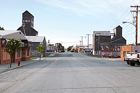
Downtown Tioga
|
|
| Motto(s):
"Oil Capital of North Dakota"
|
|

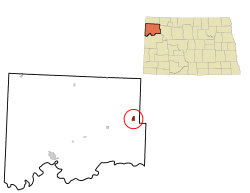
Location of Tioga, North Dakota
|
|
| Country | United States |
| State | North Dakota |
| County | Williams |
| Founded | 1902 |
| Incorporated | 1910 |
| Area | |
| • Total | 3.534 sq mi (9.153 km2) |
| • Land | 3.380 sq mi (8.754 km2) |
| • Water | 0.154 sq mi (0.399 km2) |
| Elevation | 2,241 ft (683 m) |
| Population
(2020)
|
|
| • Total | 2,202 |
| • Estimate
(2023)
|
2,097 |
| • Density | 620.3/sq mi (239.5/km2) |
| Time zone | UTC–6 (Central (CST)) |
| • Summer (DST) | UTC–5 (CDT) |
| ZIP Code |
58852
|
| Area code(s) | 701 |
| FIPS code | 38-78940 |
| GNIS feature ID | 1036295 |
| Highways | ND 40 |
| Sales tax | 8.5% |
Tioga (pronounced ty-OH-gə) is a city located in Williams County, North Dakota, United States. In 2020, the city had a population of 2,202 people.
Tioga was founded in 1902 by settlers who came from a place called Tioga, New York. The city's population grew a lot in the 1950s. This happened after oil was discovered nearby in an area known as the Williston Basin.
Contents
Geography of Tioga
Tioga covers a total area of about 9.15 square kilometers (3.53 square miles). Most of this area is land, which is about 8.75 square kilometers (3.38 square miles). The rest is water, which is about 0.39 square kilometers (0.15 square miles).
Tioga's Population History
| Historical population | |||
|---|---|---|---|
| Census | Pop. | %± | |
| 1910 | 203 | — | |
| 1920 | 320 | 57.6% | |
| 1930 | 435 | 35.9% | |
| 1940 | 385 | −11.5% | |
| 1950 | 456 | 18.4% | |
| 1960 | 2,087 | 357.7% | |
| 1970 | 1,667 | −20.1% | |
| 1980 | 1,597 | −4.2% | |
| 1990 | 1,278 | −20.0% | |
| 2000 | 1,125 | −12.0% | |
| 2010 | 1,230 | 9.3% | |
| 2020 | 2,202 | 79.0% | |
| 2023 (est.) | 2,097 | 70.5% | |
| U.S. Decennial Census 2020 Census |
|||
Population in 2020
According to the 2020 census, Tioga had 2,202 residents living in 972 households. About 518 of these were families. The city had a population density of about 240 people per square kilometer (620 people per square mile). There were 1,322 housing units in total.
Most of the people in Tioga were White (83.4%). Other groups included African American (1.7%), Native American (0.9%), and Asian (1.0%). About 13.6% of the population identified as Hispanic or Latino.
Population in 2010
In the 2010 census, Tioga had 1,230 people. There were 542 households and 323 families. The population density was about 362 people per square kilometer (939 people per square mile).
The average age of people in Tioga was 47.4 years. About 18.5% of residents were under 18 years old. About 25.4% were 65 years or older. The city had slightly more males (50.8%) than females (49.2%).
Education in Tioga
Tioga has its own school system called the Tioga School District. This district includes Central Elementary School for younger students and Tioga High School for older students.
Transportation and Industry
Oil Industry
Tioga is very important for the oil industry in North Dakota. It is located near the Clarence Iverson farm, where oil was first discovered in the state. This discovery led to a big oil boom.
Today, companies like Hess Corporation operate oil facilities near Tioga. Many local businesses also support the oil industry. Tioga is also close to North Dakota's only oil refinery, which is now owned by Tesoro.
Getting Around Tioga
Tioga is located near North Dakota Highway 40. This highway connects to U.S. Route 2. The city also has BNSF Railway freight train tracks running through it.
The Amtrak train, called the Empire Builder, passes through Tioga. However, it does not stop in the city. The closest train station for passengers is in Stanley, which is about 48 kilometers (30 miles) to the east.
Tioga also has a small airport called Tioga Municipal Airport. It is mainly used for private planes and charter flights. For commercial flights, people usually go to Williston Basin International Airport or Minot International Airport.
See also
 In Spanish: Tioga (Dakota del Norte) para niños
 | Charles R. Drew |
 | Benjamin Banneker |
 | Jane C. Wright |
 | Roger Arliner Young |

