Williston Basin facts for kids
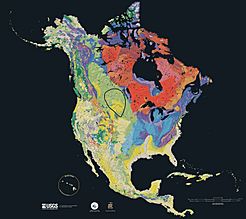
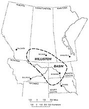
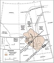
The Williston Basin is a huge, bowl-shaped area found in parts of Montana, North Dakota, South Dakota, Saskatchewan, and Manitoba. Think of it like a giant, ancient crater or a big dip in the Earth. This area is super important because it holds lots of valuable natural resources.
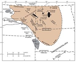
It's especially known for its rich deposits of petroleum (oil) and potash. The basin is shaped like a big oval. It stretches about 764 kilometers (475 miles) from north to south and 483 kilometers (300 miles) from east to west. The famous Missouri River also flows through it.
The Williston Basin sits on top of very old rocks, formed about 1.8 to 1.9 billion years ago. These ancient rocks created a weak spot in the Earth. Over millions of years, this weak spot slowly sank, forming the basin we see today. The deepest rocks in the center of the basin are about 4,877 meters (16,000 feet) below the surface.
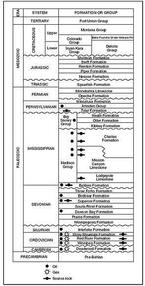
Layers of sand, mud, and other materials began to collect in the Williston area a very long time ago. This process was most active during the Ordovician, Silurian, and Devonian Periods. During these times, thick layers of limestone and dolomite were laid down. Thinner layers of sandstones, shales (hardened mud), and salt deposits also formed. This building up of layers continued for a long time, slowing down by the Mississippian Period. It mostly stopped by the Pennsylvanian Period.
Contents
Valuable Resources in the Basin
The Williston Basin is a treasure chest of natural resources. Over millions of years, the right kinds of rocks formed here. These rocks are perfect for holding oil, gas, and other important materials.
Oil and Natural Gas
The Williston Basin has a long history of producing oil and natural gas. These valuable resources are found in rocks of many different ages.
- Early Discoveries: Shallow natural gas was first found in 1913. Oil was discovered in 1936.
- The Oil Boom: The basin became a major oil producer in the 1950s. This happened after large oil fields were found in North Dakota.
- The First Big Find: In 1946, a company called Amerada Corporation started looking for oil. After years of searching, they struck oil on April 4, 1951. This discovery was near Williston, North Dakota.
- Rush for Riches: Other oil companies quickly rushed in to buy land leases. By 1954, about 80% of the possible oil-producing areas were leased. Many local farmers became rich by leasing their land.
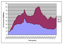
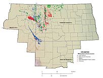
- Modern Drilling: Oil production peaked in 1986. However, in the early 2000s, production greatly increased again. This was thanks to new drilling methods like horizontal drilling, especially in the Bakken Formation.
So far, the basin has produced about 3.8 billion barrels of oil. It has also produced about 470 billion cubic feet of natural gas. Here are some of the biggest oil fields in the basin:
| Field Name | Discovery Year | Estimated Oil (million barrels) | Estimated Gas (billion cubic feet) |
|---|---|---|---|
| Elm Coulee, Montana | 2000 | 270 | |
| Beaver Lodge, North Dakota | 1951 | 130 | 115 |
| Pine, Montana | 1952 | 127 | 20 |
| Pennel, Montana | 1955 | 115 | |
| Cabin Creek, Montana | 1953 | 115 | |
| Little Knife, North Dakota | 1977 | 96 | 120 |
| Tioga, North Dakota | 1952 | 77 | 43 |
| Blue Buttes, North Dakota | 1955 | 53 | 36 |
| Charlson, North Dakota | 1952 | 52 | 100 |
Potash Mining
Potash is a type of salt used in fertilizers. It helps plants grow strong and healthy. The Williston Basin is a huge source of potash. In fact, the potash from this basin helps make Canada the world's top producer of this important material. The potash deposits are found in a rock layer called the Prairie Formation. Big companies like Nutrien and Mosaic mine potash here.
Coal Deposits
The Williston Basin also has large amounts of coal. Most of this coal is found in the Fort Union Formation. People first noticed these coal deposits during the famous Lewis and Clark Expedition.
- Early Mining: Coal mining began in 1873 near Sims, North Dakota.
- Railroad Use: The Northern Pacific Railway later took over the mine. They developed the coal beds to power their trains.
- Growth and Decline: From 1900 to 1920, the coal industry grew a lot. By 1940, there were 320 mines operating. However, production started to drop after 1951. By 1999, only 4 mines were still active.
Helium Gas
In 1952, scientists found concentrations of helium gas in southwestern Saskatchewan. Helium is a very light gas used in balloons and for scientific research.
- Production: Helium was produced from four wells between 1963 and 1977. Production started again in 2014.
- Where it Comes From: The highest amounts of helium were found in the Deadwood Formation. This helium comes from the natural breakdown of elements like uranium and thorium in the very old rocks deep underground.
Impact Craters
The Williston Basin is home to several confirmed impact craters. These are places where meteorites crashed into Earth long ago. Some of these craters include Viewfield, Red Wing Creek, and Eagle Butte. Other possible craters are still being studied.
See also
- List of possible impact structures on Earth
 | William Lucy |
 | Charles Hayes |
 | Cleveland Robinson |


