Zap, North Dakota facts for kids
Quick facts for kids
Zap, North Dakota
|
|
|---|---|

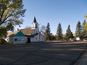
Immanuel Lutheran Church in Zap
|
|
| Nickname(s):
"The little town with a big heart"
|
|

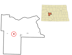
Location of Zap, North Dakota
|
|
| Country | United States |
| State | North Dakota |
| County | Mercer |
| Founded | 1913 |
| Area | |
| • Total | 1.02 sq mi (2.64 km2) |
| • Land | 1.02 sq mi (2.64 km2) |
| • Water | 0.00 sq mi (0.01 km2) |
| Elevation | 1,844 ft (562 m) |
| Population
(2020)
|
|
| • Total | 221 |
| • Estimate
(2022)
|
222 |
| • Density | 217.09/sq mi (83.78/km2) |
| Time zone | UTC-6 (Central (CST)) |
| • Summer (DST) | UTC-6 (MDT) |
| ZIP code |
58580
|
| Area code(s) | 701 |
| FIPS code | 38-88140 |
| GNIS feature ID | 1036345 |
Zap is a small city in Mercer County, North Dakota, in the United States. In 2020, 221 people lived there.
The city was started in 1913. It was built along a train line that came from Mandan. No one is completely sure how Zap got its name. Some people think it was named after a banking family from Minnesota or a coal-mining town in Scotland called Zapp. Zap is known for having a very unusual name!
Contents
The "Zip to Zap" Event
Zap is probably most famous for an event called the "Zip to Zap." This happened on May 10, 1969. It started as a fun idea for spring break.
An article in a college newspaper, picked up by news agencies, encouraged people to visit Zap. Soon, between 2,000 and 3,000 people arrived in the small town.
The party began with people gathering in the streets outside a small bar. The town's mayor saw a large bonfire and realized how many people were there. He quickly called the governor, William Guy, for help.
At dawn, the National Guard arrived. They marched in formation and helped the crowd leave Zap. The event then moved to other towns. Eventually, the governor announced that a park in Bismarck would host the crowd.
Geography of Zap
Zap is located in the flat, grassy area known as the prairie. It sits along Spring Creek, which flows into the Knife River.
The United States Census Bureau reports that the city covers about 1.05 square miles (2.72 square kilometers) of land. There is no water area within the city limits.
Climate in Zap
| Climate data for Zap - Beulah Field | |||||||||||||
|---|---|---|---|---|---|---|---|---|---|---|---|---|---|
| Month | Jan | Feb | Mar | Apr | May | Jun | Jul | Aug | Sep | Oct | Nov | Dec | Year |
| Mean daily maximum °F (°C) | 19.6 (−6.9) |
21.1 (−6.1) |
36.5 (2.5) |
52.9 (11.6) |
64.6 (18.1) |
74.0 (23.3) |
83.1 (28.4) |
80.8 (27.1) |
70.5 (21.4) |
55.5 (13.1) |
44.3 (6.8) |
20.6 (−6.3) |
52.0 (11.1) |
| Mean daily minimum °F (°C) | −3.7 (−19.8) |
1.1 (−17.2) |
14.7 (−9.6) |
30.0 (−1.1) |
37.4 (3.0) |
48.9 (9.4) |
56.1 (13.4) |
50.8 (10.4) |
41.9 (5.5) |
27.6 (−2.4) |
19.9 (−6.7) |
−0.8 (−18.2) |
27.0 (−2.8) |
| Average precipitation inches (mm) | 0.4 (10) |
0.4 (10) |
0.6 (15) |
1.1 (28) |
2.0 (51) |
3.3 (84) |
2.4 (61) |
1.8 (46) |
1.1 (28) |
1.1 (28) |
0.5 (13) |
0.4 (10) |
15.1 (380) |
| Source: Weatherbase | |||||||||||||
Population of Zap
| Historical population | |||
|---|---|---|---|
| Census | Pop. | %± | |
| 1920 | 257 | — | |
| 1930 | 406 | 58.0% | |
| 1940 | 574 | 41.4% | |
| 1950 | 425 | −26.0% | |
| 1960 | 339 | −20.2% | |
| 1970 | 271 | −20.1% | |
| 1980 | 511 | 88.6% | |
| 1990 | 287 | −43.8% | |
| 2000 | 231 | −19.5% | |
| 2010 | 237 | 2.6% | |
| 2020 | 221 | −6.8% | |
| 2022 (est.) | 222 | −6.3% | |
| U.S. Decennial Census 2020 Census |
|||
Zap's Population in 2010
In 2010, there were 237 people living in Zap. These people lived in 109 households, and 70 of these were families. The city had about 225.7 people per square mile.
Most of the people in Zap were White (91.6%). There were also Native American (3.0%), Asian (1.3%), and people of two or more races (4.2%). A small number (0.4%) were Hispanic or Latino.
About a quarter of the households (24.8%) had children under 18. Almost half (47.7%) were married couples. The average household had 2.17 people.
The average age of people in Zap was 49.1 years. About 17.7% of residents were under 18, and 16% were 65 or older. There were slightly more males (54.0%) than females (46.0%) in the city.
Education in Zap
Students in Zap attend schools in the Beulah Public School District 27.
Zap used to have its own school district. However, in 1994, the people in the district voted to close it down.
See also
 In Spanish: Zap (Dakota del Norte) para niños
 | Laphonza Butler |
 | Daisy Bates |
 | Elizabeth Piper Ensley |

