
Golden Valley County, North Dakota facts for kids
Quick facts for kids
Golden Valley County
|
|
|---|---|

Golden Valley County Courthouse in Beach
|
|

Location within the U.S. state of North Dakota
|
|
 North Dakota's location within the U.S. |
|
| Country | |
| State | |
| Founded | 1912 |
| Seat | Beach |
| Largest city | Beach |
| Area | |
| • Total | 1,002 sq mi (2,600 km2) |
| • Land | 1,001 sq mi (2,590 km2) |
| • Water | 1.6 sq mi (4 km2) 0.2% |
| Population
(2020)
|
|
| • Total | 1,736 |
| • Estimate
(2022)
|
1,744 |
| • Density | 1.7325/sq mi (0.6689/km2) |
| Time zone | UTC−7 (Mountain) |
| • Summer (DST) | UTC−6 (MDT) |
| Congressional district | At-large |
Golden Valley County is a county located in the western part of North Dakota, a state in the United States. In 2020, about 1,736 people lived here, making it one of the least populated counties in North Dakota. The main town and county seat (where the county government is) is Beach.
It's important not to confuse Golden Valley County with the city of Golden Valley. That city is actually in a different county called Mercer County.
Contents
History of Golden Valley County
Golden Valley County was created after a vote on November 8, 1910. People living in Billings County decided to split off the western part to form a new county.
There was a legal challenge, but on September 19, 1912, the North Dakota Supreme Court said the vote was valid. So, the state government officially formed Golden Valley County on November 13, 1912.
How Golden Valley Got Its Name
Early settlers used to call this area 'Rattlesnake Flats' because there were so many rattlesnakes around! But in 1902, a group of land surveyors noticed something special. When the sun shone on the grasses, they looked distinctly golden. Because of this beautiful sight, they decided to name the region Golden Valley.
Geography and Nature
Golden Valley County is located on the far western side of North Dakota. Its western border touches the state of Montana.
Rivers and Land Features
Beaver Creek flows through the northern part of the county. The Little Missouri River flows through the southeastern corner. The land here has semi-arid hills, meaning it's quite dry. The flatter areas are used for farming. The highest point in the county is about 3,251 feet (991 meters) above sea level, found in the southwestern corner.
The county covers a total area of about 1,002 square miles (2,595 square kilometers). Most of this, about 1,001 square miles (2,593 square kilometers), is land. Only a small part, about 1.6 square miles (4.1 square kilometers), is water.
Main Roads in the County
 Interstate 94
 North Dakota Highway 16
Neighboring Counties
- McKenzie County (north)
- Billings County (east)
- Slope County (south)
- Fallon County, Montana (southwest)
- Wibaux County, Montana (west)
Protected Natural Areas
Part of the Little Missouri National Grassland is located within Golden Valley County. This is a large area of protected grasslands.
Lakes in Golden Valley County
- Bosserman Lake
- Camels Hump Lake
- Odland Dam
Population and People
| Historical population | |||
|---|---|---|---|
| Census | Pop. | %± | |
| 1920 | 4,832 | — | |
| 1930 | 4,122 | −14.7% | |
| 1940 | 3,498 | −15.1% | |
| 1950 | 3,499 | 0.0% | |
| 1960 | 3,100 | −11.4% | |
| 1970 | 2,611 | −15.8% | |
| 1980 | 2,391 | −8.4% | |
| 1990 | 2,108 | −11.8% | |
| 2000 | 1,924 | −8.7% | |
| 2010 | 1,680 | −12.7% | |
| 2020 | 1,736 | 3.3% | |
| 2022 (est.) | 1,744 | 3.8% | |
| U.S. Decennial Census 1790-1960 1900-1990 1990-2000 2010-2020 |
|||
Population Changes Over Time
The population of Golden Valley County has changed over the years. In 2020, there were 1,736 people living here. In 2010, there were 1,680 people.
Most people in the county are white. Many families have German, Norwegian, or Polish backgrounds. The average age of people living here is about 45.9 years old.
Population by Decade

Towns and Communities
Golden Valley County has a few towns and smaller communities.
Cities in the County
- Beach (This is the county seat)
- Golva
- Sentinel Butte
Smaller Unincorporated Communities
These are places that don't have their own local government.
- Chama
- De Mores
- Ekre
- Rider
- Thelan
- Trotters
Townships
Townships are smaller divisions of the county, often with their own local government for specific areas.
- Beach
- Bullion
- Delhi
- Elk Creek
- Garner
- Henry
- Lone Tree
- Pearl
- Saddle Butte
- Sentinel
Former Townships
- Elmwood
Unorganized Territories
These are areas within the county that are not part of any city or township.
- East Golden Valley
- Elmwood (This used to be a township)
- North Golden Valley
- South Golden Valley
Notable People from Golden Valley County
- Ernest Viggo Almquist, a commercial artist.
- Arthur C. Townley, who started the North Dakota Nonpartisan League, a political group.
Images for kids
-
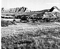
Rangeland, wooded drainageways, and badland
-
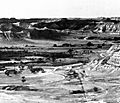
Stream valley, rangeland and badland
-
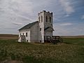
Church building in Trotters


See also
 In Spanish: Condado de Golden Valley (Dakota del Norte) para niños
