Golva, North Dakota facts for kids
Quick facts for kids
Golva, North Dakota
|
|
|---|---|

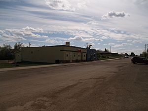
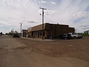
The Golva Bar and the Golva post office
|
|

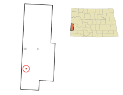
Location of Golva, North Dakota
|
|
| Country | United States |
| State | North Dakota |
| County | Golden Valley |
| Founded | 1915 |
| Area | |
| • Total | 0.32 sq mi (0.83 km2) |
| • Land | 0.32 sq mi (0.83 km2) |
| • Water | 0.00 sq mi (0.00 km2) |
| Elevation | 2,831 ft (863 m) |
| Population
(2020)
|
|
| • Total | 84 |
| • Estimate
(2022)
|
85 |
| • Density | 262.50/sq mi (101.35/km2) |
| Time zone | UTC-7 (Mountain (MST)) |
| • Summer (DST) | UTC-6 (MDT) |
| ZIP code |
58632
|
| Area code(s) | 701 |
| FIPS code | 38-31420 |
| GNIS feature ID | 1034887 |
Golva is a small city located in Golden Valley County, North Dakota, in the United States. In 2020, about 84 people lived there. The city was started in 1915.
Contents
History of Golva
Golva is found in an area called Lone Tree Township. Early settlers, known as homesteaders, arrived here between 1900 and 1910. They found only one tree in the whole area. This tree stood about one mile (1.6 km) east of where Golva is today. It died around 1980.
The Homestead Act allowed settlers to get 160 acres (0.65 km2) of land. They just had to live on it for seven years. In western North Dakota, they could get another 160 acres (0.65 km2) if they planted trees. This is why many farms in the area now have trees around them.
One of the last original homesteaders from the Golva area was Mrs. George (Emma) Geary. She passed away in 1978. She still owned her homestead and house. She had left her home in 1958 after breaking her hip. Doctors thought she would be bedridden. But she was very determined and walked with one crutch. She lived alone until shortly before she died at 89.
Her neighbor, Eva Weinreis, wrote a book about her life. It was called A Note On the Tea Kettle. Eva and her husband, Peter Weinreis, came from Aberdeen, South Dakota in 1906. They settled two miles (3 km) west of Burkey, North Dakota. Their story shared much about the early days of the Golva area.
How Golva Started
Golva was founded in 1915. This happened when the Northern Pacific Railroad line came through from Beach, North Dakota. The city was first planned to be the main town, or county seat, of Golden Valley County.
The name "Golva" comes from the first three letters of "Golden" and the first two letters of "Valley." A.L. Martin, who owned the land where the town was built, suggested the name. The name "Golden Valley" describes the rolling hills of golden wheat fields before harvest time.
Before 1915, most local businesses were in a place called Burkey. Burkey was about four miles (6 km) southwest of Golva. St. Mary's Catholic Church was built in Burkey in 1906. But it moved to Golva soon after the new city was founded. The Golva post office opened on February 15, 1916. Other businesses also moved from Burkey to Golva. Burkey quickly disappeared within a few years.
Businesses in Golva
Golva once had many businesses. These included a hardware store, a grocery store, and a car dealership. There was also a lumberyard, two grain elevators, and two bars. Several restaurants and other shops were also present.
As of 2017, Golva had fewer businesses. These included a lumberyard, a gas station, a grocery store, and a bank. There was also a grain elevator. The city still had its post office and St. Mary's Catholic Church.
Geography of Golva
Golva is located at 46°44′6″N 103°59′10″W / 46.73500°N 103.98611°W. This is its exact position on a map.
The United States Census Bureau says that the city covers a total area of 0.33 square miles (0.85 km2). All of this area is land. There is no water within the city limits.
Population of Golva
| Historical population | |||
|---|---|---|---|
| Census | Pop. | %± | |
| 1950 | 174 | — | |
| 1960 | 162 | −6.9% | |
| 1970 | 104 | −35.8% | |
| 1980 | 101 | −2.9% | |
| 1990 | 101 | 0.0% | |
| 2000 | 106 | 5.0% | |
| 2010 | 61 | −42.5% | |
| 2020 | 84 | 37.7% | |
| 2022 (est.) | 85 | 39.3% | |
| U.S. Decennial Census 2020 Census |
|||
2010 Census Information
The census of 2010 counted 61 people living in Golva. These people lived in 37 households. There were 13 families among them. The city had about 185 people per square mile (71 per km2). All of the people living in Golva were White.
Out of the 37 households, 21.6% had children under 18 years old living with them. About 29.7% were married couples. A small number, 5.4%, had a male head of household with no wife present. Most households, 64.9%, were not families.
Many households, 62.2%, had only one person living in them. About 21.6% of these single-person households were people aged 65 or older. The average household had 1.65 people. The average family had 2.77 people.
The average age of people in Golva was 51.2 years. About 18% of residents were under 18. Only 3.2% were between 18 and 24. A large group, 47.5%, were between 45 and 64 years old. About 21.3% were 65 years or older. The population was 45.9% male and 54.1% female.
Education in Golva
Golva High School and Golva Elementary School were in the same building. This was true from 1920 until 1972. In 1972, a new elementary school was built next to the high school.
In 1989, the high school closed. It was later torn down. This happened because not enough students were enrolled. Also, it would have cost too much to update the building to new safety rules.
Students from kindergarten through 8th grade still go to Golva Elementary School. However, high school students now travel to Beach, North Dakota for their classes.
Climate
Golva has a semi-arid climate. This means it is usually dry, but not a true desert. It gets more rain than a desert, but not enough to be considered humid. This type of climate is called "BSk" on climate maps.
See also
 In Spanish: Golva (Dakota del Norte) para niños
 | Percy Lavon Julian |
 | Katherine Johnson |
 | George Washington Carver |
 | Annie Easley |


