Watford City, North Dakota facts for kids
Quick facts for kids
Watford City, North Dakota
|
|
|---|---|

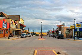
Main Street Watford City
|
|
| Motto(s):
"Come be our guest"
|
|

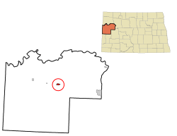
Location in North Dakota
|
|
| Country | United States |
| State | North Dakota |
| County | McKenzie |
| Founded | 1914 |
| Incorporated | June 1915 |
| Area | |
| • Total | 9.056 sq mi (23.455 km2) |
| • Land | 8.977 sq mi (23.251 km2) |
| • Water | 0.079 sq mi (0.204 km2) |
| Elevation | 2,054 ft (626 m) |
| Population
(2020)
|
|
| • Total | 6,207 |
| • Estimate
(2023)
|
6,020 |
| • Density | 671.0/sq mi (258.9/km2) |
| Time zone | UTC–6 (Central (CST)) |
| • Summer (DST) | UTC–5 (CDT) |
| ZIP Code |
58854
|
| Area code(s) | 701 |
| FIPS code | 38-83860 |
| GNIS feature ID | 1036317 |
| Highways | US 85, ND 23, ND 23 Alt. |
| Sales tax | 6.5% |
Watford City is a city in North Dakota, United States. It was founded in 1914. It is the main town, or county seat, of McKenzie County, North Dakota.
In 2020, about 6,207 people lived there. This makes it the 13th largest city in North Dakota. Watford City has grown a lot since 2010. This is because it is near the Bakken oil field, which led to a big oil boom in North Dakota.
Some important businesses have offices in Watford City. These include Frontier Energy Group and First International Bank. The main office for McKenzie Electric Cooperative is also here. The local newspaper is called the McKenzie County Farmer.
Contents
History of Watford City
How Watford City Began
In 1913, some business people came to the area where Watford City is now. They were waiting for the first train from the Great Northern Railroad. The railroad's land company planned the town in June 1914. They started selling land lots right away. Many businesses and homes moved from a nearby town called Schafer. Schafer later became a ghost town.
Watford was officially made a town in June 1915. It was named by Vaughan G. Morris after his hometown, Watford, in Ontario, Canada. A year later, "City" was added to the name. This was to make sure people didn't confuse it with Wolford in Pierce County.
Early Town Life
In 1915, the town elected its first leaders. They made rules about things like stray horses and chickens. They also decided where people could tie up their horses. Watford City had a town band and a baseball team from the very beginning. A school and several churches were built quickly.
During the Great Depression, a water and sewer system was built. Most of the workers were paid by the Public Works Administration. This was a government program that helped people find jobs.
Becoming the County Seat
In 1940, Watford City won a big competition to become the county seat. This meant it would be the main town for McKenzie County. It won against Alexander and Arnegard. Before this, Schafer was the county seat.
At first, it was hard to find office space for the county. So, a new hospital building was sold to the county to be used as a courthouse. A new hospital was built in 1952. The Watford City Air Force Station opened nearby in 1979.
Geography of Watford City
Watford City covers about 9.056 square miles (23.455 square kilometers). Most of this area is land, and a small part is water.
Population and People
| Historical population | |||
|---|---|---|---|
| Census | Pop. | %± | |
| 1920 | 260 | — | |
| 1930 | 769 | 195.8% | |
| 1940 | 1,023 | 33.0% | |
| 1950 | 1,371 | 34.0% | |
| 1960 | 1,865 | 36.0% | |
| 1970 | 1,768 | −5.2% | |
| 1980 | 2,119 | 19.9% | |
| 1990 | 1,784 | −15.8% | |
| 2000 | 1,435 | −19.6% | |
| 2010 | 1,744 | 21.5% | |
| 2020 | 6,207 | 255.9% | |
| 2023 (est.) | 6,020 | 245.2% | |
| U.S. Decennial Census 2020 Census |
|||
Population in 2020
In 2020, there were 6,207 people living in Watford City. There were 2,449 households, which are groups of people living together. About 1,390 of these were families.
Most people in Watford City were White (about 73.7%). Other groups included African American (2.4%), Native American (2.0%), and Asian (2.2%). About 18.7% of the people were Hispanic or Latino.
About 29.2% of the people were under 18 years old. About 7.4% were 65 years old or older.
Transportation in Watford City
Northwest Dakota Public Transit offers a "dial-a-ride" service in Watford City. This means you can call and arrange for a ride. This service runs on weekdays from 7:30 AM to 4:00 PM and from 5:00 PM to 9:00 PM. A ride costs $3.
Education in Watford City
Students in Watford City attend these schools:
- Watford City Elementary School
- Watford City High School
Places to Visit
There are several interesting places near Watford City:
- Theodore Roosevelt National Park (North Unit)
- Maah Daah Hey Trail
- McKenzie County Heritage Park
- Long X Trading Post Visitor Center
- Pioneer Museum of McKenzie County
Climate in Watford City
Watford City has a humid continental climate. This means it has big changes in temperature between seasons. Summers are warm to hot, and often humid. Winters are cold, sometimes very cold.
The wettest time of year is from late spring to early summer. Winter is the driest season.
| Climate data for Watford City, North Dakota (1991–2020 normals, extremes 1912–present) | |||||||||||||
|---|---|---|---|---|---|---|---|---|---|---|---|---|---|
| Month | Jan | Feb | Mar | Apr | May | Jun | Jul | Aug | Sep | Oct | Nov | Dec | Year |
| Record high °F (°C) | 60 (16) |
64 (18) |
81 (27) |
92 (33) |
103 (39) |
110 (43) |
112 (44) |
111 (44) |
103 (39) |
96 (36) |
77 (25) |
66 (19) |
112 (44) |
| Mean daily maximum °F (°C) | 21.6 (−5.8) |
26.2 (−3.2) |
38.8 (3.8) |
53.1 (11.7) |
64.8 (18.2) |
74.1 (23.4) |
82.2 (27.9) |
81.6 (27.6) |
71.1 (21.7) |
54.7 (12.6) |
38.0 (3.3) |
26.2 (−3.2) |
52.7 (11.5) |
| Daily mean °F (°C) | 13.4 (−10.3) |
17.2 (−8.2) |
28.8 (−1.8) |
41.8 (5.4) |
53.5 (11.9) |
63.5 (17.5) |
70.0 (21.1) |
68.5 (20.3) |
58.0 (14.4) |
43.7 (6.5) |
29.0 (−1.7) |
18.0 (−7.8) |
42.1 (5.6) |
| Mean daily minimum °F (°C) | 5.1 (−14.9) |
8.1 (−13.3) |
18.8 (−7.3) |
30.5 (−0.8) |
42.1 (5.6) |
52.9 (11.6) |
57.9 (14.4) |
55.4 (13.0) |
44.9 (7.2) |
32.6 (0.3) |
20.0 (−6.7) |
9.9 (−12.3) |
31.5 (−0.3) |
| Record low °F (°C) | −45 (−43) |
−44 (−42) |
−30 (−34) |
−13 (−25) |
12 (−11) |
19 (−7) |
32 (0) |
29 (−2) |
10 (−12) |
−7 (−22) |
−22 (−30) |
−36 (−38) |
−45 (−43) |
| Average precipitation inches (mm) | 0.50 (13) |
0.41 (10) |
0.63 (16) |
0.96 (24) |
2.38 (60) |
3.44 (87) |
2.63 (67) |
1.35 (34) |
1.16 (29) |
1.04 (26) |
0.60 (15) |
0.55 (14) |
15.65 (398) |
| Average snowfall inches (cm) | 9.5 (24) |
8.2 (21) |
7.3 (19) |
4.2 (11) |
1.4 (3.6) |
0.0 (0.0) |
0.0 (0.0) |
0.0 (0.0) |
0.0 (0.0) |
2.9 (7.4) |
6.8 (17) |
10.1 (26) |
50.4 (128) |
| Average precipitation days (≥ 0.01 in) | 6.9 | 5.7 | 6.5 | 7.6 | 11.1 | 12.6 | 9.4 | 8.6 | 7.3 | 6.6 | 6.1 | 6.9 | 95.3 |
| Average snowy days (≥ 0.1 in) | 8.1 | 6.3 | 5.0 | 2.5 | 0.7 | 0.0 | 0.0 | 0.0 | 0.0 | 1.5 | 4.6 | 7.5 | 36.2 |
| Source: NOAA | |||||||||||||
See also
 In Spanish: Watford City (Dakota del Norte) para niños
 | Janet Taylor Pickett |
 | Synthia Saint James |
 | Howardena Pindell |
 | Faith Ringgold |

