Dawson County, Montana facts for kids
Quick facts for kids
Dawson County
|
|
|---|---|

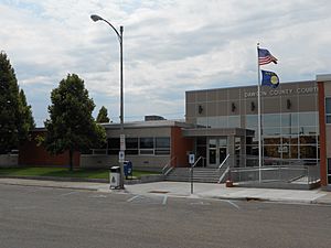
Dawson County Courthouse in Glendive
|
|

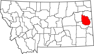
Location within the U.S. state of Montana
|
|
 Montana's location within the U.S. |
|
| Country | |
| State | |
| Founded | January 15, 1869 |
| Seat | Glendive |
| Largest city | Glendive |
| Area | |
| • Total | 2,383 sq mi (6,170 km2) |
| • Land | 2,372 sq mi (6,140 km2) |
| • Water | 11 sq mi (30 km2) 0.5% |
| Population
(2020)
|
|
| • Total | 8,940 |
| • Estimate
(2022)
|
8,830 |
| • Density | 3.7516/sq mi (1.4485/km2) |
| Time zone | UTC−7 (Mountain) |
| • Summer (DST) | UTC−6 (MDT) |
| Congressional district | 2nd |
|
|
Dawson County is a county in the state of Montana. It's located in the eastern part of Montana. In 2020, about 8,940 people lived there. The main town and county seat is Glendive.
Contents
History of Dawson County
Dawson County was one of the first counties created in Montana Territory. It was officially formed on January 15, 1869. This was about four and a half years after Montana became a territory.
Before Dawson County existed, this area was the northern part of Big Horn County. The county is named after Major Andrew Dawson. He managed a trading post called Fort Benton Trading Post from 1856 to 1864.
Geography and Nature
Dawson County covers a total area of about 2,383 square miles. Most of this is land, with only a small part being water.
The county is in the far eastern part of Montana. It is close to the border with North and South Dakota.
Unique Landscapes
Dawson County has a special type of landscape called badlands. These areas have unusual rock formations. Makoshika State Park is a great example of these cool formations.
The main rivers in Dawson County are the Yellowstone River and the Redwater River. Many smaller creeks flow into these rivers. These waterways help provide water for farms and animals.
Dinosaur Discovery
In 1992, the largest Triceratops skull ever found was discovered here. It was dug up in 2003 in the famous Hell Creek Formation. This skull is 65 million years old. It is over 9 feet long and weighs more than 1,300 pounds! This amazing fossil was named 'Dragon King'.
How Dawson County Changed
Over the years, parts of Dawson County were used to create other counties. These include Valley County, Richland County, Wibaux County, Prairie County, Garfield County, and McCone County.
Main Roads
Here are some of the major roads that go through Dawson County:
 Interstate 94
 U.S. Highway 10 (This road used to be here)
 Montana Highway 16
 Montana Highway 200
 Montana Highway 200 (Another part of Highway 200)
- Montana Highway 254
Bus Services
- Jefferson Lines provides bus service in the area.
Neighboring Counties
Dawson County shares borders with these counties:
- Richland County - to the north
- Wibaux County - to the east
- Prairie County - to the south
- McCone County - to the west
Population of Dawson County
| Historical population | |||
|---|---|---|---|
| Census | Pop. | %± | |
| 1890 | 2,056 | — | |
| 1900 | 2,443 | 18.8% | |
| 1910 | 12,725 | 420.9% | |
| 1920 | 9,239 | −27.4% | |
| 1930 | 9,881 | 6.9% | |
| 1940 | 8,618 | −12.8% | |
| 1950 | 9,092 | 5.5% | |
| 1960 | 12,314 | 35.4% | |
| 1970 | 11,269 | −8.5% | |
| 1980 | 11,805 | 4.8% | |
| 1990 | 9,505 | −19.5% | |
| 2000 | 9,059 | −4.7% | |
| 2010 | 8,966 | −1.0% | |
| 2020 | 8,940 | −0.3% | |
| 2022 (est.) | 8,830 | −1.5% | |
| U.S. Decennial Census 1790–1960, 1900–1990, 1990–2000, 2010–2020 |
|||
The population of Dawson County was 8,940 people in 2020. In 2010, there were 8,966 people living in the county.
Economy and Jobs
Dawson County is known for its farms, especially for growing grain without much extra water. It also has coal mines and wells that produce natural gas and oil. There are over 500 farms and ranches in the county.
The area has a lot of lignite coal. Natural gas has been used in Glendive since at least 1920. There are also good clays for making pottery and bricks.
Farming and Ranching
For a long time, Dawson County has been great for raising livestock. This is because of the rich, healthy grass. The livestock industry is still important today. In the early 1900s, the county was known for raising pure-bred animals, dairy farming, and producing hogs and chickens.
Most of the land in Dawson County is flat or gently rolling. This makes it excellent for farming. The soil is dark and sandy, which is good for growing crops.
Barley, oats, and wheat were the main crops in the early 1900s. A large part of the land can be farmed, and the rest is good for grazing animals. Farmers in Dawson County have even won awards for their corn!
Education
Dawson Community College is a college located in Glendive, Dawson County.
Communities
Cities and Towns
Other Communities
- West Glendive (This is a census-designated place, a community without its own local government)
- Bloomfield (An unincorporated community)
- Lindsay (An unincorporated community)
See also
 In Spanish: Condado de Dawson (Montana) para niños
 | Shirley Ann Jackson |
 | Garett Morgan |
 | J. Ernest Wilkins Jr. |
 | Elijah McCoy |


