
Prairie County, Montana facts for kids
Quick facts for kids
Prairie County
|
|
|---|---|

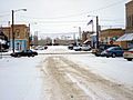
Downtown Terry, Montana during a typical snowy day.
|
|

Location within the U.S. state of Montana
|
|
 Montana's location within the U.S. |
|
| Country | |
| State | |
| Founded | February 5, 1915 |
| Named for | Prairie landscape |
| Seat | Terry |
| Largest town | Terry |
| Area | |
| • Total | 1,743 sq mi (4,510 km2) |
| • Land | 1,737 sq mi (4,500 km2) |
| • Water | 5.8 sq mi (15 km2) 0.3% |
| Population
(2020)
|
|
| • Total | 1,088 |
| • Estimate
(2022)
|
1,107 |
| • Density | 0.6/sq mi (0.2/km2) |
| Time zone | UTC−7 (Mountain) |
| • Summer (DST) | UTC−6 (MDT) |
| Congressional district | 2nd |
| Website | (Terry Chamber of Commerce) |
|
|
Prairie County is a county located in the state of Montana in the United States. In 2020, about 1,088 people lived there. This makes it one of the smallest counties in Montana by population. The main town and county seat is Terry. Prairie County was formed in 1915 from parts of other counties: Custer, Dawson, and Fallon. The name "Prairie" was chosen because the area has a lot of open grassland.
A sad event happened here in 1938. It was called the Custer Creek train wreck. This accident caused many injuries and fatalities.
Contents
Geography of Prairie County
Prairie County covers a total area of about 1,743 square miles (4,514 square kilometers). Most of this area, about 1,737 square miles (4,499 square kilometers), is land. The rest is water, which makes up about 0.3% of the total area.
Main Roads in the County
Two important roads pass through Prairie County:
 Interstate 94
- Montana Highway 253
Neighboring Counties
Prairie County shares borders with several other counties:
- McCone County - to the north
- Dawson County - to the northeast
- Wibaux County - to the east
- Fallon County - to the southeast
- Custer County - to the south
- Garfield County - to the west
Population Changes Over Time
| Historical population | |||
|---|---|---|---|
| Census | Pop. | %± | |
| 1920 | 3,684 | — | |
| 1930 | 3,941 | 7.0% | |
| 1940 | 2,410 | −38.8% | |
| 1950 | 2,377 | −1.4% | |
| 1960 | 2,318 | −2.5% | |
| 1970 | 1,752 | −24.4% | |
| 1980 | 1,836 | 4.8% | |
| 1990 | 1,383 | −24.7% | |
| 2000 | 1,199 | −13.3% | |
| 2010 | 1,179 | −1.7% | |
| 2020 | 1,088 | −7.7% | |
| 2022 (est.) | 1,107 | −6.1% | |
| U.S. Decennial Census 1790–1960, 1900–1990, 1990–2000, 2010–2020 |
|||
The population of Prairie County has changed over the years. In 1920, there were 3,684 people. By 2020, the population was 1,088. This shows a decrease in the number of people living in the county over many decades.
Towns and Communities
Prairie County has one main town and several smaller communities.
Main Town
- Terry is the largest town and the county seat. This means it's where the county government offices are located.
Designated Place
- Fallon is a census-designated place. This is a special area that the government counts for population, but it's not an officially incorporated town.
Other Small Communities
Images for kids
-
Downtown Terry, Montana during a typical snowy day.
See also
 In Spanish: Condado de Prairie (Montana) para niños
