Garfield County, Montana facts for kids
Quick facts for kids
Garfield County
|
|
|---|---|

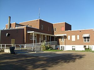
Garfield County Courthouse in Jordan
|
|

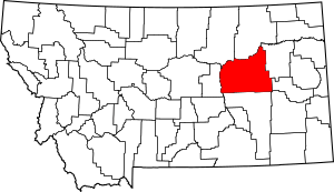
Location within the U.S. state of Montana
|
|
 Montana's location within the U.S. |
|
| Country | |
| State | |
| Founded | February 7, 1919 |
| Seat | Jordan |
| Largest town | Jordan |
| Area | |
| • Total | 4,847 sq mi (12,550 km2) |
| • Land | 4,675 sq mi (12,110 km2) |
| • Water | 172 sq mi (450 km2) 3.6% |
| Population
(2020)
|
|
| • Total | 1,173 |
| • Estimate
(2022)
|
1,218 |
| Time zone | UTC−7 (Mountain) |
| • Summer (DST) | UTC−6 (MDT) |
| Congressional district | 2nd |
|
|
Garfield County is a county located in the state of Montana, USA. Its main town, where the county government is located, is called Jordan. In 2020, about 1,173 people lived here. Garfield County is famous because some of the most complete Tyrannosaurus rex dinosaur skeletons in the world were found here! You can even see a copy of a T. rex skull at the Garfield County Museum.
Contents
Geography
Garfield County covers a large area of 4,847 square miles (about 12,554 square kilometers). Most of this is land (4,675 square miles), and a smaller part is water (172 square miles). It's one of the least crowded counties in the United States, outside of Alaska. This means there aren't many people living in each square mile.
Main Roads
These are the important highways that run through Garfield County:
Neighboring Counties
Garfield County shares its borders with several other counties:
- Phillips County – to the northwest
- Valley County – to the north
- McCone County – to the east
- Prairie County – to the east
- Custer County – to the southeast
- Rosebud County – to the south
- Petroleum County – to the west
Protected Areas
Part of the Charles M. Russell National Wildlife Refuge is located in Garfield County. This refuge helps protect wildlife and their natural homes.
Population History
| Historical population | |||
|---|---|---|---|
| Census | Pop. | %± | |
| 1920 | 5,368 | — | |
| 1930 | 4,252 | −20.8% | |
| 1940 | 2,641 | −37.9% | |
| 1950 | 2,172 | −17.8% | |
| 1960 | 1,981 | −8.8% | |
| 1970 | 1,796 | −9.3% | |
| 1980 | 1,656 | −7.8% | |
| 1990 | 1,589 | −4.0% | |
| 2000 | 1,279 | −19.5% | |
| 2010 | 1,206 | −5.7% | |
| 2020 | 1,173 | −2.7% | |
| 2022 (est.) | 1,218 | 1.0% | |
| U.S. Decennial Census 1790–1960, 1900–1990, 1990–2000, 2010–2020 |
|||
The population of Garfield County has changed over the years. In 1920, there were over 5,000 people living here. By 2020, the population was 1,173. The estimated population for 2022 was slightly higher, at 1,218 people.
2010 Census Details
In 2010, there were 1,206 people living in Garfield County. These people lived in 532 households, and 347 of these were families. Most of the people living in the county were white (98.6%). The average household had about 2.27 people. The average age of people in the county was 46.4 years old.
Communities
Town
- Jordan (This is the county seat, meaning it's where the county government is located.)
Other Communities
These are smaller, unincorporated communities in Garfield County:
- Benzien
- Big Dry
- Brusett
- Cohagen
- Haxby
- Hillside
- Mosby
- Sand Springs
- Tindall
See also
 In Spanish: Condado de Garfield (Montana) para niños
 | William Lucy |
 | Charles Hayes |
 | Cleveland Robinson |

