
Petroleum County, Montana facts for kids
Quick facts for kids
Petroleum County
|
|
|---|---|
.jpg)
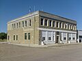
Petroleum County Courthouse in Winnett
|
|

Location within the U.S. state of Montana
|
|
 Montana's location within the U.S. |
|
| Country | |
| State | |
| Founded | February 25, 1925 |
| Named for | Petroleum fields |
| Seat | Winnett |
| Largest town | Winnett |
| Area | |
| • Total | 1,674 sq mi (4,340 km2) |
| • Land | 1,655 sq mi (4,290 km2) |
| • Water | 19 sq mi (50 km2) 1.1% |
| Population
(2020)
|
|
| • Total | 496 |
| • Estimate
(2022)
|
524 |
| • Density | 0.2963/sq mi (0.11440/km2) |
| Time zone | UTC−7 (Mountain) |
| • Summer (DST) | UTC−6 (MDT) |
| Congressional district | 2nd |
|
|
Petroleum County is a county located in the state of Montana in the United States. In 2020, about 496 people lived here. This makes it the county with the fewest people in Montana. It is also one of the least populated counties in the entire United States. The main town and county seat is Winnett. Petroleum County was created in 1925 from parts of Fergus County. It was the very last of Montana's 56 counties to be formed.
Contents
History of Petroleum County
Early Native American Life
Long ago, this area was home to several Native American tribes. These included the Crow, Blackfoot, Nez Perce, and Sioux tribes. They lived on these lands for many years.
How Winnett Town Started
In 1868, a trading post was built near the Musselshell River. It was called "Musselshell." Later, in 1879, a rancher named Walter John Winnett started a ranch. He was even adopted into the Sioux tribe. His ranch house, built in 1900, became a place where people gathered. In 1910, he opened a store and asked for a post office. This is how Winnett officially became a town.
Cattle and Gold Discoveries
A fort called Fort Magginis was built in 1880. It helped stop Native American raids in the area. This allowed cattle ranching to grow and become very successful. Gold was also found in the mountains of Fergus County. From 1911 to 1915, many people came to claim land for gold prospecting. However, by 1930, many of these lands went back to the government. This happened because settlers left the town.
Oil Discovery and County Creation

In February 1920, oil was found in the southeastern part of the county. This area became known as the Cat Creek Oil Field. It produced high-quality oil. By 1922, this oil field was producing 2.2 million barrels of oil each year! Because of this important discovery, the state government decided to create a new county. In 1925, they split the eastern part of Fergus County. They named the new area Petroleum County. This name showed that it was the first place in Montana where oil was found. Winnett was chosen as its main town.
Population Changes Over Time
Petroleum County has always had very few people living in it. Its population has continued to get smaller over the years. In 1930, there were 2,045 residents. By 1980, the population had dropped to just 685 people.
Geography of Petroleum County

The eastern edge of Petroleum County is formed by the Musselshell River. The county covers a total area of about 1,674 square miles. Most of this is land, with about 19 square miles of water. The land is part of the Missouri Plateau, which is a section of the Great Plains. The county's elevation ranges from about 2,250 to 4,000 feet above sea level. The land mostly has rolling hills and valleys. However, there are also sharp, deep cuts near the Missouri and Musselshell Rivers. The southern part of the county has gentle hills and valleys mixed with steep cliffs.
Major Roads in the County
- U.S. Route 87
- State Highway 200
- State Highway 244
Rivers and Lakes
The county has two main rivers:
There are also several lakes:
- Wild Horse Lake
- Little Bear Lake
- War Horse Lake
- Petrolia Lake
- Yellow Water Reservoir
- Headman-Field Reservoir
The northern part of the county has a lot of surface water. However, there is not much farmland there to use it. In other parts of the county, farms rely on water from underground.
Neighboring Counties
Petroleum County shares borders with these counties:
- Phillips County – to the north
- Garfield County – to the east
- Rosebud County – to the southeast
- Musselshell County – to the south
- Fergus County – to the west
Climate and Weather
The county gets about 13 inches of rain each year. The average temperature is between 42 and 47 degrees Fahrenheit. Frost occurs for about 105 to 135 days each year. Most of the rain, about 70%, falls from April to September. This is also the main growing season for many crops. The average snowfall is around 40 inches. Winds average about 17 miles per hour, and they are stronger in winter.
Protected Natural Areas
.jpg)
Petroleum County is home to two important wildlife refuges:
- War Horse National Wildlife Refuge
- Charles M. Russell National Wildlife Refuge
Geology and Fossils

A ridge made of sandstone runs along the northern part of the county. This ridge holds oil and gas. It divides the county into two main areas. To the north, you find geological layers called Bearpaw Shale or Hell Creek Formation. To the south, there are older Cretaceous rocks. You can see marine shales from the Cretaceous Age all over the county. Sandstones are also found in layers and deeper underground in the Cat Creek area.
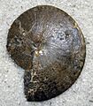
Interesting fossil discoveries have been made here. A Tyrannosauridae skeleton was found in the Judith River Formation. Also, an Alamosaurus fossil was discovered in the Hell Creek Formation.
Plants and Animals
Common Plants
The rangelands in Petroleum County have many types of plants. These include wheatgrass, forbs (flowering plants), and shrubs. You can also find green needlegrass, blue grama, big sagebrush, and plains prickly pear. Forested areas cover over 64,000 acres. Here, you will see Ponderosa pine, Douglas fir, and Plains cottonwood trees.
Wildlife in the County
The county is home to many animals. You can find elk, white-tailed deer, mule deer, and pronghorn antelope. Birds like pheasant, eagles, and Gray (or Hungarian) partridge also live here.
Economy and Jobs
The main ways people make a living in Petroleum County are through oil production and cattle ranching. Raising livestock (like cattle) brings in almost 90% of the money for farms. Crude oil from the Cat Creek and Rattlesnake Butte fields is sent through pipes to oil refineries in Billings.
About 66% of the people in the county work in farming, forestry, fishing, and hunting. A large number, 58.2%, work in mining. Another 15.5% work in education, health, and social services.
Some well-known ranches in the county include McArthur Ranch, Maxwell Ranch, Crooked Creek Campground, Fail Ranch, and Novak Homestead. In 2012, the average farm size was 6,045 acres. The main crops grown are wheat (both winter and spring wheat) and barley. Alfalfa and grass hay are grown to feed cattle. These crops are grown in irrigated areas along the main rivers and creeks.
Population Information
| Historical population | |||
|---|---|---|---|
| Census | Pop. | %± | |
| 1930 | 2,045 | — | |
| 1940 | 1,083 | −47.0% | |
| 1950 | 1,026 | −5.3% | |
| 1960 | 894 | −12.9% | |
| 1970 | 675 | −24.5% | |
| 1980 | 655 | −3.0% | |
| 1990 | 519 | −20.8% | |
| 2000 | 493 | −5.0% | |
| 2010 | 494 | 0.2% | |
| 2020 | 496 | 0.4% | |
| 2022 (est.) | 524 | 6.1% | |
| U.S. Decennial Census 1790–1960, 1900–1990, 1990–2000, 2010–2020 |
|||
What the 2020 Census Shows
The 2020 census counted 496 people living in Petroleum County.
What the 2010 Census Showed
In 2010, there were 494 people living in the county. These people lived in 225 households, with 143 of them being families. The county had about 0.3 people per square mile. Most of the people, 98.8%, were white. About 1.0% of the population was of Hispanic or Latino background.
Many people had German (35.1%), Norwegian (15.9%), English (15.7%), or Irish (13.2%) ancestry. About 28% of households had children under 18 living with them. The average age of people in the county was 47.3 years old. The average income for a household was $36,875. About 16.7% of the population lived below the poverty line.
Images for kids
-
Petroleum County Courthouse in Winnett
-
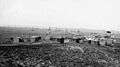
Cat Creek Oil Field
-
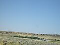
Winnett Rims from the Highway
-
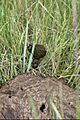
Dung beetles on the War Horse NWR
-
A fossil ammonite from Petroleum County
See also
 In Spanish: Condado de Petroleum para niños
