Phillips County, Montana facts for kids
Quick facts for kids
Phillips County
|
|
|---|---|

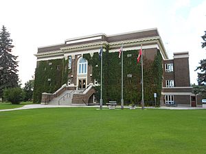
Phillips County Courthouse in Malta
|
|

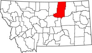
Location within the U.S. state of Montana
|
|
 Montana's location within the U.S. |
|
| Country | |
| State | |
| Founded | February 5, 1915 |
| Seat | Malta |
| Largest city | Malta |
| Area | |
| • Total | 5,212 sq mi (13,500 km2) |
| • Land | 5,140 sq mi (13,300 km2) |
| • Water | 72 sq mi (190 km2) 1.4% |
| Population
(2020)
|
|
| • Total | 4,217 |
| • Estimate
(2022)
|
4,240 |
| • Density | 0.80909/sq mi (0.31239/km2) |
| Time zone | UTC−7 (Mountain) |
| • Summer (DST) | UTC−6 (MDT) |
| Congressional district | 2nd |
|
|
Phillips County is a special area of land in the state of Montana, USA. It is like a large district with its own local government. In 2020, about 4,217 people lived here. The main town and center of the county is Malta.
Phillips County was officially created on February 5, 1915. Before that, it was part of Blaine County. Even earlier, before 1912, both were part of Chouteau County. The county is named after Benjamin D. Phillips, who was a rancher and a state senator.
The northern edge of Phillips County touches the border with Saskatchewan, a province in Canada. The Missouri River forms the southern border of the county.
Contents
Geography of Phillips County
Phillips County is a very large area. It covers about 5,212 square miles (13,500 square kilometers). Most of this land, about 5,140 square miles (13,310 square kilometers), is dry land. The rest, about 72 square miles (186 square kilometers), is water, like rivers and lakes.
This makes Phillips County the second-largest county in Montana by land area. It is also the third-largest county in Montana when you count both land and water.
Neighboring Areas
Phillips County shares its borders with several other counties in Montana and some rural areas in Canada.
- Blaine County - to the west
- Fergus County - to the southwest
- Petroleum County - to the south
- Garfield County - to the southeast
- Valley County - to the east
- Rural Municipality (RM) of Lone Tree No. 18, Saskatchewan (SK) - to the north
- RM of Val Marie No. 17, SK - to the north
- RM of Mankota No. 45, SK - to the northeast
Protected Natural Areas
Phillips County is home to parts of several important natural areas. These places are protected to help wildlife and nature thrive.
- Bowdoin National Wildlife Refuge
- Charles M. Russell National Wildlife Refuge (part of it)
- Hewitt Lake National Wildlife Refuge
- UL Bend National Wildlife Refuge
- Upper Missouri River Breaks National Monument (part of it)
People of Phillips County
The number of people living in Phillips County has changed over the years. Here is a quick look at the population from past records:
| Historical population | |||
|---|---|---|---|
| Census | Pop. | %± | |
| 1920 | 9,311 | — | |
| 1930 | 8,208 | −11.8% | |
| 1940 | 7,892 | −3.8% | |
| 1950 | 6,334 | −19.7% | |
| 1960 | 6,027 | −4.8% | |
| 1970 | 5,386 | −10.6% | |
| 1980 | 5,367 | −0.4% | |
| 1990 | 5,163 | −3.8% | |
| 2000 | 4,601 | −10.9% | |
| 2010 | 4,253 | −7.6% | |
| 2020 | 4,217 | −0.8% | |
| 2022 (est.) | 4,240 | −0.3% | |
| U.S. Decennial Census 1790–1960, 1900–1990, 1990–2000, 2010–2020 |
|||
Population in 2020
According to the official count in 2020, there were 4,217 people living in Phillips County.
Population in 2010
In 2010, there were 4,253 people living in the county. These people lived in 1,819 households, and 1,159 of these were families. The county had about 0.8 people per square mile. There were also 2,335 homes or housing units.
Most people in the county were white (87.0%). About 8.3% were American Indian, and smaller groups were Asian or from other backgrounds. About 1.9% of the people were of Hispanic or Latino origin.
Many families in Phillips County had children under 18 living with them (27.6%). About 52.9% of households were married couples. The average age of people in the county was 46.8 years old.
The average income for a household was $36,453 per year. For families, it was $55,362 per year. About 13.5% of all people in the county lived below the poverty line. This included 17.1% of those under 18 years old.
Communities in Phillips County
Phillips County has several towns and smaller communities where people live.
City
- Malta (This is the main town and the county seat.)
Towns
Census-designated places
These are areas that are like towns but are not officially incorporated as cities or towns.
- East Malta Colony
- Landusky
- Loring Colony
- Sleeping Buffalo
- Whitewater
- Zortman
Other Unincorporated Communities
These are smaller places that do not have their own local government.
See also
 In Spanish: Condado de Phillips (Montana) para niños
 | DeHart Hubbard |
 | Wilma Rudolph |
 | Jesse Owens |
 | Jackie Joyner-Kersee |
 | Major Taylor |

