Blaine County, Montana facts for kids
Quick facts for kids
Blaine County
|
|
|---|---|

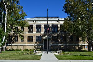
Blaine County Courthouse in Chinook
|
|

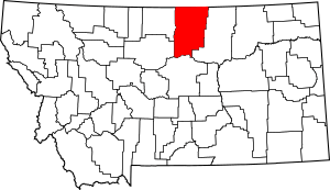
Location within the U.S. state of Montana
|
|
 Montana's location within the U.S. |
|
| Country | |
| State | |
| Founded | 1912 |
| Named for | James G. Blaine |
| Seat | Chinook |
| Largest city | Chinook |
| Area | |
| • Total | 4,239 sq mi (10,980 km2) |
| • Land | 4,228 sq mi (10,950 km2) |
| • Water | 11 sq mi (30 km2) 0.3% |
| Population
(2020)
|
|
| • Total | 7,044 |
| • Estimate
(2022)
|
6,936 |
| • Density | 1.66171/sq mi (0.64159/km2) |
| Time zone | UTC−7 (Mountain) |
| • Summer (DST) | UTC−6 (MDT) |
| Congressional district | 2nd |
|
|
Blaine County is a special area in the state of Montana, USA. It's like a big district with its own local government. In 2020, about 7,044 people lived there. The main town, or county seat, where the county government is located, is Chinook.
Blaine County got its name from James G. Blaine. He was an important person in American history who served as the United States Secretary of State. This county is right on the northern edge of Montana, which means it shares a border with Saskatchewan, a province in Canada.
Contents
History of Blaine County
How Blaine County Was Formed
Blaine County was created in 1912. Before that, it was part of a much larger area called Chouteau County. At the same time, two other counties, Phillips County and Hill County, were also formed from parts of Chouteau County.
When Blaine County was first made, its border was a bit different. A small piece of land that is now in Phillips County used to be part of Blaine County.
Geography of Blaine County
What Does Blaine County Look Like?
Blaine County is a large area. It covers about 4,239 square miles (10,980 square kilometers). Most of this area, about 4,228 square miles (10,950 square kilometers), is land. The rest, about 11 square miles (28 square kilometers), is water, like rivers and lakes.
A big part of the Fort Belknap Indian Reservation is located in the southeastern section of Blaine County. This reservation is home to the Gros Ventre and Assiniboine tribes.
Natural Features of Blaine County
Blaine County has some interesting natural spots. You can find the Milk River flowing through it. There are also two mountain ranges: the Bears Paw Mountains and the Little Rocky Mountains.
Neighboring Areas of Blaine County
Blaine County shares its borders with several other counties in Montana and even some areas in Canada:
- To the west is Hill County.
- To the southwest is Chouteau County.
- To the south is Fergus County.
- To the east is Phillips County.
- To the north, it borders parts of Saskatchewan, Canada.
Protected Natural Places in Blaine County
Several special protected areas are found partly within Blaine County. These places help protect wildlife and important historical sites:
- Black Coulee National Wildlife Refuge
- Nez Perce National Historical Park (part of it)
- Upper Missouri River Breaks National Monument (part of it)
People of Blaine County
How Many People Live in Blaine County?
The number of people living in Blaine County has changed over the years.
| Historical population | |||
|---|---|---|---|
| Census | Pop. | %± | |
| 1920 | 9,057 | — | |
| 1930 | 9,006 | −0.6% | |
| 1940 | 9,566 | 6.2% | |
| 1950 | 8,516 | −11.0% | |
| 1960 | 8,091 | −5.0% | |
| 1970 | 6,727 | −16.9% | |
| 1980 | 6,999 | 4.0% | |
| 1990 | 6,728 | −3.9% | |
| 2000 | 7,009 | 4.2% | |
| 2010 | 6,491 | −7.4% | |
| 2020 | 7,044 | 8.5% | |
| 2022 (est.) | 6,936 | 6.9% | |
| U.S. Decennial Census 1790–1960, 1900–1990, 1990–2000, 2010–2020 |
|||
In 2020, the census counted 7,044 people living in Blaine County. In 2010, there were 6,491 people. About half of the people in 2010 were Native American, and about half were white. A small number of people were from other backgrounds.
Economy of Blaine County
What Do People Do for Work?
The main type of work in Blaine County is agriculture. This means many people work with farming and ranching. On the Fort Belknap Indian Reservation, the biggest employers are the Gros Ventre and Assiniboine tribes themselves.
Education in Blaine County
Schools and Colleges
Blaine County has several places for learning. Aaniiih Nakoda College (which used to be called Fort Belknap College) is located on the Fort Belknap Indian Reservation.
There are also public high schools in the county:
- Harlem High School in Harlem
- Chinook High School in Chinook
- Turner High School in Turner
Communities in Blaine County
Main Towns in Blaine County
Other Communities in Blaine County
There are also smaller towns and communities in Blaine County, including:
- Fort Belknap Agency
- Hartland Colony
- Hays
- Hogeland
- Lodge Pole
- North Harlem Colony
- Turner
- Turner Colony
- Zurich
- Cleveland
- Lloyd
- Lohman
- North Fork
- Rattlesnake
- Savoy
Images for kids
See also
 In Spanish: Condado de Blaine (Montana) para niños
 | Isaac Myers |
 | D. Hamilton Jackson |
 | A. Philip Randolph |


