Harlem, Montana facts for kids
Quick facts for kids
Harlem
|
|
|---|---|

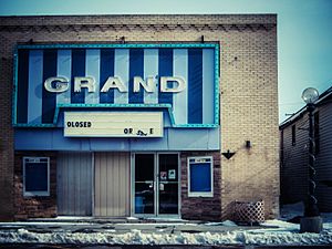
Cinema in Harlem, March 2012
|
|
| Motto(s):
Heartbeat of the Milk River Valley
|
|

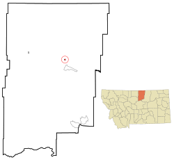
Location of Harlem, Montana
|
|
| Country | United States |
| State | Montana |
| County | Blaine |
| Area | |
| • Total | 0.42 sq mi (1.08 km2) |
| • Land | 0.42 sq mi (1.08 km2) |
| • Water | 0.00 sq mi (0.00 km2) |
| Elevation | 2,366 ft (721 m) |
| Population
(2020)
|
|
| • Total | 769 |
| • Density | 1,839.71/sq mi (709.82/km2) |
| Time zone | UTC-7 (Mountain (MST)) |
| • Summer (DST) | UTC-6 (MDT) |
| ZIP code |
59526
|
| Area code(s) | 406 |
| FIPS code | 30-34375 |
| GNIS feature ID | 2410702 |
Harlem is a small city located in Blaine County, Montana, in the United States. In 2020, about 769 people lived there.
Just south of Harlem, across the Milk River, is the Fort Belknap Indian Reservation.
Harlem got its name from Haarlem, a city in the Netherlands. This was a common practice for towns along the Hi-Line. The Hi-Line is a railway route built by the Great Northern Railway. A. A. Cecil planned the town in 1889.
Contents
Where is Harlem, Montana?
Harlem is in Montana, a state in the western United States. The city covers an area of about 1.08 square kilometers (0.42 square miles). All of this area is land.
What is the weather like in Harlem?
Harlem has a climate with cold winters and warm summers. The temperature can change a lot throughout the year.
| Climate data for Harlem, Montana (1991–2020 normals, extremes 1896–present) | |||||||||||||
|---|---|---|---|---|---|---|---|---|---|---|---|---|---|
| Month | Jan | Feb | Mar | Apr | May | Jun | Jul | Aug | Sep | Oct | Nov | Dec | Year |
| Record high °F (°C) | 66 (19) |
74 (23) |
82 (28) |
95 (35) |
98 (37) |
107 (42) |
107 (42) |
107 (42) |
102 (39) |
91 (33) |
87 (31) |
69 (21) |
107 (42) |
| Mean maximum °F (°C) | 53.4 (11.9) |
56.0 (13.3) |
66.4 (19.1) |
79.6 (26.4) |
85.8 (29.9) |
92.6 (33.7) |
97.2 (36.2) |
98.3 (36.8) |
91.5 (33.1) |
79.0 (26.1) |
66.5 (19.2) |
54.2 (12.3) |
100.2 (37.9) |
| Mean daily maximum °F (°C) | 28.2 (−2.1) |
32.7 (0.4) |
45.0 (7.2) |
58.8 (14.9) |
69.0 (20.6) |
76.6 (24.8) |
85.0 (29.4) |
84.7 (29.3) |
74.1 (23.4) |
59.7 (15.4) |
43.3 (6.3) |
30.9 (−0.6) |
57.3 (14.1) |
| Daily mean °F (°C) | 16.6 (−8.6) |
20.8 (−6.2) |
32.5 (0.3) |
44.4 (6.9) |
54.3 (12.4) |
62.6 (17.0) |
69.3 (20.7) |
68.2 (20.1) |
57.9 (14.4) |
45.1 (7.3) |
31.1 (−0.5) |
19.8 (−6.8) |
43.6 (6.4) |
| Mean daily minimum °F (°C) | 5.0 (−15.0) |
8.9 (−12.8) |
19.9 (−6.7) |
29.9 (−1.2) |
39.7 (4.3) |
48.7 (9.3) |
53.5 (11.9) |
51.6 (10.9) |
41.7 (5.4) |
30.4 (−0.9) |
18.9 (−7.3) |
8.7 (−12.9) |
29.7 (−1.3) |
| Mean minimum °F (°C) | −24.5 (−31.4) |
−17.3 (−27.4) |
−4.3 (−20.2) |
13.5 (−10.3) |
24.9 (−3.9) |
36.2 (2.3) |
43.3 (6.3) |
38.4 (3.6) |
26.7 (−2.9) |
10.4 (−12.0) |
−6.7 (−21.5) |
−15.2 (−26.2) |
−32.1 (−35.6) |
| Record low °F (°C) | −50 (−46) |
−50 (−46) |
−37 (−38) |
−12 (−24) |
10 (−12) |
26 (−3) |
35 (2) |
30 (−1) |
13 (−11) |
−20 (−29) |
−35 (−37) |
−44 (−42) |
−50 (−46) |
| Average precipitation inches (mm) | 0.51 (13) |
0.36 (9.1) |
0.52 (13) |
1.00 (25) |
1.89 (48) |
2.90 (74) |
1.44 (37) |
0.99 (25) |
1.09 (28) |
0.73 (19) |
0.57 (14) |
0.50 (13) |
12.50 (318) |
| Average precipitation days (≥ 0.01 in) | 4.8 | 3.6 | 4.7 | 6.2 | 9.5 | 12.1 | 6.7 | 5.2 | 5.3 | 5.0 | 5.3 | 4.0 | 72.4 |
| Source: NOAA | |||||||||||||
Who lives in Harlem?
The number of people living in Harlem has changed over the years. Here's a look at the population from 1910 to 2020:
| Historical population | |||
|---|---|---|---|
| Census | Pop. | %± | |
| 1910 | 383 | — | |
| 1920 | 721 | 88.3% | |
| 1930 | 708 | −1.8% | |
| 1940 | 1,166 | 64.7% | |
| 1950 | 1,107 | −5.1% | |
| 1960 | 1,267 | 14.5% | |
| 1970 | 1,094 | −13.7% | |
| 1980 | 1,023 | −6.5% | |
| 1990 | 882 | −13.8% | |
| 2000 | 848 | −3.9% | |
| 2010 | 808 | −4.7% | |
| 2020 | 769 | −4.8% | |
| U.S. Decennial Census | |||
Harlem's Population in 2010
In 2010, there were 808 people living in Harlem. They lived in 307 households, and 204 of these were families.
- About 42.1% of the people were White.
- About 52.2% were Native American.
- A small number were from other backgrounds.
- About 4.0% of the population were Hispanic or Latino.
Many households (36.2%) had children under 18 living with them. The average household had about 2.49 people. The average family had about 3.08 people.
The average age of people in Harlem was 36.6 years old.
- About 28.6% of residents were under 18.
- About 17% were 65 years or older.
- More females (54.7%) lived in Harlem than males (45.3%).
Schools and Learning
Harlem has schools for all ages, from young children to adults.
- Harlem Elementary School teaches students from kindergarten to 6th grade.
- Harlem Middle School is for 7th and 8th graders.
- Harlem High School serves students from 9th to 12th grade. Their sports teams are called the Wildcats!
In the 2021-2022 school year, the elementary and middle schools had 453 students. The high school had 175 students.
Harlem is also home to Aaniiih Nakoda College. This is a two-year college where students can earn associate degrees. They can also get training for different jobs.
The Harlem Public Library is available for everyone in the area to read and learn.
Local News
The local newspaper in Harlem is called the Blaine County Journal News-Opinion. It comes out once a week. You can read it in print or online.
Roads and Travel
Harlem is easy to get to by road.
- U.S. Route 2 runs along the southern edge of the town.
- Highway 241 goes north from Harlem. It leads to the border crossing into Canada.
Airports Near Harlem
- Harlem Airport is a small public airport about 6 kilometers (3 miles) north of town.
- The closest airport with some commercial flights is Havre City–County Airport. It's about 48 kilometers (30 miles) east.
- For more flight options, people usually travel to Great Falls International Airport or Billings Logan International Airport. Both are about 320 kilometers (200 miles) away.
Train Travel
The Amtrak train, called the Empire Builder, goes through Harlem. This train travels between Seattle/Portland and Chicago. However, it does not stop in Harlem. The closest train stations are in Havre (about 43 miles west) and Malta (about 45 miles east).
Famous People from Harlem
Some people who have lived in Harlem have become well-known, especially in politics:
- Francis Bardanouve: A politician.
- Ken Hansen: A state senator.
- Frank Warnke: Another politician.
See also
 In Spanish: Harlem (Montana) para niños
 | Valerie Thomas |
 | Frederick McKinley Jones |
 | George Edward Alcorn Jr. |
 | Thomas Mensah |

