
Black Elk Peak facts for kids
Quick facts for kids Black Elk Peak |
|
|---|---|

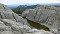
Black Elk Peak, the highest point in South Dakota viewed from Black Elk Peak Trail, May 2018.
|
|
| Highest point | |
| Elevation | 7,244 ft (2,208 m) NAVD 88 |
| Prominence | 2,922 ft (891 m) |
| Listing |
|
| Geography | |

Black Elk Peak
Location in South Dakota

Black Elk Peak
Location in the United States
|
|
| Country | United States |
| State | South Dakota |
| County | Pennington County |
| Parent range | Black Hills |
| Topo map | USGS Custer |
| Climbing | |
| First ascent | July 24, 1875 by Valentine McGillycuddy and party |
| Easiest route | hike, Trail 9 |
Black Elk Peak is the highest natural point in the U.S. state of South Dakota. It is also the highest point in the entire Midwestern United States. This important peak is found in the Black Elk Wilderness area, located in southern Pennington County. It is part of the beautiful Black Hills National Forest.
The peak stands at about 7,244 feet (2,208 m) tall. This makes it the highest summit in the United States that is east of the Rocky Mountains. Even though it's part of a larger mountain system, it's usually seen as geologically separate from the Rockies.
For many years, this peak was known as Harney Peak. However, its name was officially changed to Black Elk Peak on August 11, 2016. This change honored Black Elk, a famous Lakota Sioux medicine man. The wilderness area around the peak is also named after him. The Lakota people have their own names for the peak too: Hiŋháŋ Káǧa (meaning 'owl-maker') and Heȟáka Sápa (meaning 'elk black').
The peak is home to a historic fire lookout tower and a staircase. A nearby dam and pumphouse are also part of this special site. These structures were added to the National Register of Historic Places in 1983 because of their importance.
Contents
Why Was Black Elk Peak Renamed?
This mountain has a long history with the Lakota Sioux people. They called it Hiŋháŋ Káǧa, or "Owl maker." This name came from rock formations that looked like owls. Owls were also linked to important spiritual meanings for the Lakota. The Lakota considered this peak a sacred place within the Black Hills, which they called Pahá Sápa and Ȟé Sápa.
The Name Harney Peak
The mountain was named Harney Peak in 1855 by an American officer named Gouverneur K. Warren. He named it after US General William S. Harney. General Harney was involved in a conflict in September 1855 where many Lakota people were killed.
The Lakota people tried for 50 years to get the name of the peak changed. They felt that naming it after General Harney was disrespectful because of his actions against their people.
Efforts to Change the Name
In 2014, the Sioux people renewed their efforts to change the name. A Korean War veteran named Basil Brave Heart led this movement. He felt that Harney's actions did not honor the military.
In 2015, the Lakota Council of the Pine Ridge Reservation and the family of Black Elk supported naming the peak after him. They felt it was a good choice since the wilderness area around the peak was already named for this wise medicine man. Black Elk became well-known through the book Black Elk Speaks (1932). This book was written by John G. Neihardt after many talks with Black Elk.
Even though some state officials in South Dakota were against the change, the U.S. Board on Geographic Names voted unanimously to change the name. On August 11, 2016, the mountain was officially renamed "Black Elk Peak." A week later, the Governor of South Dakota announced that the state would accept the new name.
History of Black Elk Peak
|
Harney Peak Lookout Tower, Dam, Pumphouse and Stairway
|
|
.jpg)
Fire tower at Black Elk Peak
|
|
| Nearest city | Custer, South Dakota |
|---|---|
| Area | 4 acres (1.6 ha) |
| Built | 1935–1938 |
| Built by | Civilian Conservation Corps |
| NRHP reference No. | 83003019 |
| Added to NRHP | March 10, 1983 |
Black Elk Peak and the Black Hills were part of the Great Sioux Reservation. This reservation was created by the United States government in the Treaty of Fort Laramie in 1868. This treaty gave the Lakota people a large area of land west of the Missouri River in South Dakota.
Early Explorers and Settlers
In 1874, a group led by General George Armstrong Custer explored the Black Hills. They are believed to be the first American settlers to reach the summit of the peak. A few years later, in 1877, the federal government took back the Black Hills. In 1889, the Great Sioux Reservation was divided into five smaller reservations. This happened the same year that North Dakota and South Dakota became states.
Black Elk's Vision
Black Elk Peak is a very special place for Black Elk, the famous Lakota Sioux medicine man. When he was nine years old, he had his "Great Vision" on this peak. This vision guided his life and made him known for his wisdom.
Later in his life, Black Elk returned to the peak with writer John Neihardt. Black Elk shared many stories about his life and beliefs with Neihardt. Neihardt then wrote the book Black Elk Speaks (1932) to share Black Elk's wisdom with the world.
Black Elk described his vision on the peak:
"I was standing on the highest mountain of them all, and round about beneath me was the whole hoop of the world," he is quoted as saying. "And while I stood there I saw more than I can tell and I understood more than I saw; for I was seeing in a sacred manner the shapes of all things in the spirit, and the shape of all shapes as they must live together like one being."
The Fire Lookout Tower
American settlers started using Black Elk Peak as a fire lookout tower in 1911. At first, it was just a simple wooden crate at the top. In 1920, a small wooden building was constructed. It was made larger the next year.
During the Great Depression, the federal Civilian Conservation Corps (CCC) helped build many projects. In 1938, the CCC built a strong stone fire tower on the peak. This tower was used to spot fires until 1967.
A man-made dam was also built on the peak in 1935. This concrete tank can hold 5,000 US gallons (19,000 L; 4,200 imp gal) of water. A pumphouse was added in 1938. In 1982, the lookout tower, its stairway, the dam, and the pumphouse were nominated for the National Register of Historic Places. They were officially added to the register on March 10, 1983.
Hiking to Black Elk Peak
.jpg)
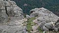
There are several ways to reach the summit of Black Elk Peak. You can start your hike from places like Sylvan Lake, Camp Remington, Highway 244, Palmer Creek Road, Mount Rushmore, or Horse Thief Lake.
The most popular way to hike to the summit is from the trailhead at Sylvan Lake. This route is about 7 miles (11 km) round trip. It is the shortest and easiest path to the top. You don't need a special permit to use the trail itself. However, you will need a South Dakota State Parks pass to get into the Sylvan Lake area where the trail begins.
At the summit, you will find the old stone tower that was once used as a fire lookout. Near the base of the tower, you can find a plaque for Valentine McGillycuddy. His ashes were placed there. The plaque reads, "Valentine McGillycuddy, Wasicu Wakan." Wasicu Wakan is a Lakota phrase meaning "Holy White Man."
Images for kids
-
Granite Knob and Harney's Peak, by William H. Illingworth, 1874
-
View from the top of the Black Elk Peak lookout tower.
-
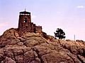
Fire lookout tower at the summit.
-
A Mountain goat near the top of Black Elk Peak.
-
A man-made dam is located near the summit.
-
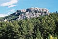
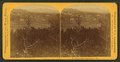
Black Elk Peak from Palmer Gulch (August 2006)
-
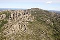
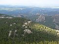
Aerial view of Black Elk Peak and surrounding area
,_1842-1893.png)


.jpg)
