
Custer, South Dakota facts for kids
Quick facts for kids
Custer
|
||
|---|---|---|
| Custer, South Dakota | ||
 |
||
|
||

Location in Custer County and the state of South Dakota
|
||
| Country | ||
| State | ||
| County | Custer | |
| Founded | 1875 | |
| Area | ||
| • Total | 2.54 sq mi (6.58 km2) | |
| • Land | 2.53 sq mi (6.55 km2) | |
| • Water | 0.01 sq mi (0.03 km2) | |
| Elevation | 5,315 ft (1,620 m) | |
| Population
(2020)
|
||
| • Total | 1,919 | |
| • Density | 758.50/sq mi (292.81/km2) | |
| Time zone | UTC−7 (MST) | |
| • Summer (DST) | UTC−6 (MDT) | |
| Zip Code |
57730
|
|
| Area code(s) | 605 | |
| FIPS code | 46-15140 | |
| GNIS feature ID | 1265633 | |
| Website | City of Custer | |

Custer is a city in Custer County, South Dakota, United States. In 2020, about 1,919 people lived there. It is the main town, or county seat, of Custer County.
Contents
History of Custer

Custer is the oldest town in the Black Hills that was started by European Americans. In 1874, gold was found east of Custer during an exploration trip led by Lt. Colonel George Armstrong Custer. This discovery started the Black Hills Gold Rush, where many people rushed to the area looking for gold.
For thousands of years, the Black Hills were home to different indigenous peoples (native groups). At the time Americans arrived, the Oglala Sioux tribe lived there. The U.S. government had set aside this land for them in a special agreement called the Treaty of Fort Laramie (1868). The Oglala Sioux considered the Black Hills a very important and sacred place.
As more Americans moved into the area, there were conflicts. In 1877, the U.S. government made the Sioux give up much of the Black Hills. This opened the land for people to buy and settle. In 1875, gold seekers started a settlement and first called it Stonewall. But it was soon renamed Custer.
In 1876, many people left Custer when they heard about bigger gold finds in a place called Deadwood Gulch. However, Custer later grew into an established city. It has always been smaller and less wealthy than other nearby cities like Deadwood and Lead. Besides gold, Custer's economy also relied on mining other important minerals.
Every year, Custer celebrates "Gold Discovery Days" in late July. This event celebrates the finding of gold near French Creek and the start of the town.
Geography and Climate
Custer is a small city, covering about 2.54 square miles (6.58 square kilometers). Most of this area is land, with a tiny bit of water.
Weather in Custer
Custer has a climate with warm summers and cold, changing winters. In summer, afternoons are warm, but mornings are cool.
Winter weather can be very different. Sometimes, cold air comes from Canada. Other times, warm winds called "chinook winds" can make winter temperatures surprisingly high. For example, on January 19, 1963, it was -43°F (-41.7°C). But just over two weeks later, on February 5, it reached 65°F (18.3°C)!
On average, the first freezing temperature happens around September 6, and the last around June 2. This means Custer has about 95 days without frost. It snows about 57.9 inches (147 cm) each year. However, the chinook winds often melt the snow, so there isn't usually a lot of snow on the ground.
Summers in Custer are milder than in the flat Great Plains because of its higher elevation. Temperatures rarely go above 90°F (32.2°C). Most rain falls from thunderstorms in spring and early summer.
| Climate data for Custer, South Dakota (elevation 5,480 feet (1,670 m)), 1991–2020 normals, extremes 1942–present | |||||||||||||
|---|---|---|---|---|---|---|---|---|---|---|---|---|---|
| Month | Jan | Feb | Mar | Apr | May | Jun | Jul | Aug | Sep | Oct | Nov | Dec | Year |
| Record high °F (°C) | 68 (20) |
68 (20) |
72 (22) |
84 (29) |
90 (32) |
97 (36) |
100 (38) |
96 (36) |
97 (36) |
85 (29) |
76 (24) |
68 (20) |
100 (38) |
| Mean maximum °F (°C) | 54.9 (12.7) |
53.6 (12.0) |
63.2 (17.3) |
71.6 (22.0) |
78.9 (26.1) |
86.8 (30.4) |
90.9 (32.7) |
89.2 (31.8) |
85.8 (29.9) |
74.7 (23.7) |
62.3 (16.8) |
53.5 (11.9) |
92.2 (33.4) |
| Mean daily maximum °F (°C) | 37.1 (2.8) |
37.2 (2.9) |
45.6 (7.6) |
51.3 (10.7) |
61.2 (16.2) |
72.3 (22.4) |
79.7 (26.5) |
78.7 (25.9) |
70.9 (21.6) |
55.7 (13.2) |
44.9 (7.2) |
36.5 (2.5) |
55.9 (13.3) |
| Daily mean °F (°C) | 26.6 (−3.0) |
26.6 (−3.0) |
34.8 (1.6) |
40.9 (4.9) |
50.8 (10.4) |
61.0 (16.1) |
68.0 (20.0) |
66.7 (19.3) |
58.5 (14.7) |
44.7 (7.1) |
34.3 (1.3) |
26.5 (−3.1) |
44.9 (7.2) |
| Mean daily minimum °F (°C) | 16.2 (−8.8) |
16.1 (−8.8) |
24.0 (−4.4) |
30.5 (−0.8) |
40.5 (4.7) |
49.6 (9.8) |
56.3 (13.5) |
54.6 (12.6) |
46.0 (7.8) |
33.7 (0.9) |
23.7 (−4.6) |
16.6 (−8.6) |
34.0 (1.1) |
| Mean minimum °F (°C) | −9.1 (−22.8) |
−7.9 (−22.2) |
1.2 (−17.1) |
12.2 (−11.0) |
24.4 (−4.2) |
35.9 (2.2) |
43.8 (6.6) |
40.3 (4.6) |
28.6 (−1.9) |
12.6 (−10.8) |
1.4 (−17.0) |
−6.4 (−21.3) |
−17.8 (−27.7) |
| Record low °F (°C) | −43 (−42) |
−34 (−37) |
−30 (−34) |
−8 (−22) |
5 (−15) |
19 (−7) |
30 (−1) |
22 (−6) |
8 (−13) |
−10 (−23) |
−25 (−32) |
−37 (−38) |
−43 (−42) |
| Average precipitation inches (mm) | 0.36 (9.1) |
0.70 (18) |
0.92 (23) |
2.24 (57) |
3.53 (90) |
3.43 (87) |
3.16 (80) |
2.43 (62) |
1.53 (39) |
1.45 (37) |
0.55 (14) |
0.36 (9.1) |
20.66 (525) |
| Average snowfall inches (cm) | 6.6 (17) |
10.7 (27) |
10.7 (27) |
11.0 (28) |
2.1 (5.3) |
0.0 (0.0) |
0.0 (0.0) |
0.0 (0.0) |
0.8 (2.0) |
3.9 (9.9) |
6.7 (17) |
5.4 (14) |
57.9 (147) |
| Average precipitation days (≥ 0.01 in) | 4.2 | 5.9 | 6.2 | 9.7 | 14.4 | 12.7 | 10.6 | 8.9 | 6.8 | 6.2 | 4.1 | 3.8 | 93.5 |
| Average snowy days (≥ 0.1 in) | 4.4 | 6.2 | 5.2 | 4.3 | 0.8 | 0.0 | 0.0 | 0.0 | 0.3 | 2.1 | 4.0 | 3.9 | 31.2 |
| Source: NOAA | |||||||||||||
People of Custer
| Historical population | |||
|---|---|---|---|
| Census | Pop. | %± | |
| 1880 | 271 | — | |
| 1890 | 790 | 191.5% | |
| 1900 | 599 | −24.2% | |
| 1910 | 602 | 0.5% | |
| 1920 | 595 | −1.2% | |
| 1930 | 1,203 | 102.2% | |
| 1940 | 1,845 | 53.4% | |
| 1950 | 2,017 | 9.3% | |
| 1960 | 2,105 | 4.4% | |
| 1970 | 1,597 | −24.1% | |
| 1980 | 1,830 | 14.6% | |
| 1990 | 1,741 | −4.9% | |
| 2000 | 1,860 | 6.8% | |
| 2010 | 2,067 | 11.1% | |
| 2020 | 1,919 | −7.2% | |
| U.S. Decennial Census | |||
Population in 2010

In 2010, there were 1,987 people living in Custer. These people lived in 956 households, and 535 of these were families. The city had about 817 people per square mile (315 per square kilometer). There were 1,129 homes in total.
Most of the people in Custer were White (94.8%). A smaller number were Native American (2.6%), or from other backgrounds. About 2.6% of the population was Hispanic or Latino.
In 2010, about 24.3% of households had children under 18. Many households (44.5%) were married couples living together. About 40.2% of all households were single people living alone. The average age in Custer was 47.5 years old.
Economy and Tourism

Custer's main way of making money comes from tourism and services for visitors. This is especially true since a local sawmill and mining company closed.
Custer is the main office for the Black Hills National Forest in South Dakota and Wyoming. It's a great place to stay if you want to visit many popular tourist spots. These include Jewel Cave National Monument, Wind Cave National Park, Custer State Park, and Mount Rushmore National Memorial. The huge Crazy Horse Memorial is also just north of the city.
Custer also has a local hospital, Monument Health Custer Hospital. It offers different medical services like a clinic, physical therapy, and an emergency room.
Notable People
- Tyler Schultz, an American athlete who won a silver medal in shot put at the 2011 World Youth Championships.
Images for kids
-
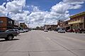
A view of Custer, South Dakota.
-

The official seal of Custer, South Dakota.
-
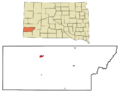
Map showing Custer's location in Custer County, South Dakota.
See also
 In Spanish: Custer (Dakota del Sur) para niños
