
Badlands National Park facts for kids
Quick facts for kids Badlands National Park |
|
|---|---|
|
IUCN Category II (National Park)
|
|

Badlands National Park
|
|

Badlands National Park
Location in South Dakota

Badlands National Park
Location in the United States
|
|
| Location | South Dakota, United States |
| Nearest city | Rapid City, South Dakota |
| Area | 242,756 acres (982.40 km2) |
| Established | January 25, 1939 as a National Monument November 10, 1978 as a National Park |
| Visitors | 1,006,809 (in 2022) |
| Governing body | National Park Service |
| Website | Badlands National Park |

Badlands National Park (which means "Makȟóšiča" in the Lakota language) is an amazing national park in southwestern South Dakota. This park protects over 242,000 acres (about 980 square kilometers) of cool, sharply eroded buttes and pinnacles. It also has the biggest untouched mixed grass prairie in the United States. The National Park Service looks after the park. The South Unit is even shared with the Oglala Lakota tribe.
A large part of the park, called the Badlands Wilderness, is a special protected area. It's one place where the black-footed ferret, a super rare animal, was brought back to the wild. The South Unit, also known as the Stronghold District, has important historical sites. It was once a place for special dances called Ghost Dances in the 1890s. It also has the park's highest point, Red Shirt Table.
Badlands became a National Monument in 1939 and a National Park in 1978. The Ben Reifel Visitor Center was built in the late 1950s to welcome visitors. The movies Dances with Wolves (1990) and Thunderheart (1992) were partly filmed here.
This national park was originally land belonging to the Oglala Sioux Indians. The Stronghold Table area was especially important to them as a sacred place. In 1868, the United States promised the Sioux that the Badlands would always be theirs. But in 1889, this promise was broken, and the land was taken by the United States.
At the end of the 1800s, the Sioux Indians used this area for the Ghost Dance. This ceremony was meant to bring back buffalo and the spirits of their ancestors. After the last Ghost Dance in 1890, the United States banned the ritual. However, it was brought back by the Red Power movement in the 1960s. This movement worked to restore Native American rights. In 1980, the U.S. Supreme Court said the Sioux should be paid for the broken treaty, but the Sioux did not accept the money.
Discovering Badlands National Park
A Look at the Park's Past
Native American History in the Badlands
For 11,000 years, Native Americans have used this area for hunting. Long before the Lakota, there were the paleo-Indians and then the Arikara people. Their families still live in North Dakota today.
Old records and stories show that these people camped in hidden valleys. They found fresh water and animals there all year. You can still find rocks and charcoal from their campfires in the stream banks. Also, arrowheads and tools they used to hunt bison and other animals are found. From the top of the Badlands Wall, they could watch for enemies and animal herds. If hunting was good, they might stay through winter. Then they would go back to their villages along the Missouri River.
The Lakota people were the first to call this place "mako sica." This means "bad lands." It got this name because of the extreme temperatures, lack of water, and rough land. French-Canadian fur trappers also called it "les mauvaises terres pour traverser," meaning "bad lands to travel through." About 150 years ago, the Great Sioux Nation, including the Oglala Lakota, had moved other tribes out of the northern prairie.
A big change happened in the late 1800s when homesteaders moved into South Dakota. The U.S. government took much of the Native Americans' land. They forced them to live on reservations. In late 1890, many Oglala Sioux followed an Indian prophet named Wovoka. He taught them to dance the Ghost Dance and wear special shirts. He said these shirts would stop bullets. Wovoka believed white people would disappear and their hunting grounds would return.
One of the last known Ghost Dances happened on Stronghold Table in the park's South Unit. As winter came, the Ghost Dancers went back to Pine Ridge Agency. The struggle ended in December 1890. A group of Minneconjou Sioux were trying to reach the Pine Ridge Reservation. U.S. Army soldiers caught them near Wounded Knee Creek. Gunfire started, and nearly 300 Indians and 30 soldiers died. This event, called the Wounded Knee Massacre, was the last big fight between Plains Indians and the U.S. military for a long time.
Wounded Knee is about 45 miles (72 km) south of the park. The U.S. government and the Oglala Lakota Nation agree that the Oglala and Minneconjou people should tell the story of this tragic event.
Amazing Fossils in the Badlands

The White River Badlands have been known for their amazing paleontological (fossil) finds for a long time. Native Americans knew about the large fossilized bones, seashells, and turtle shells. They correctly guessed that the area was once underwater. They also knew the bones belonged to creatures that no longer existed.
People started looking for fossils here in the 1840s. Trappers and traders often traveled through the area. In 1843, a fossil jawbone found its way to a doctor named Hiram A. Prout. In 1846, Prout wrote about the jaw, saying it came from a creature he called a Paleotherium. Soon after, the White River Badlands became a popular place for fossil hunting. Many new fossil species were found within a few decades.
By 1854, 77 of the 84 new species found in North America came from the White River Badlands. In 1870, a Yale professor, O. C. Marsh, visited the area. He found better ways to dig up and put together fossils into almost complete skeletons. Since 1899, the South Dakota School of Mines has sent teams almost every year. They are still one of the most active groups working in the White River Badlands.
Scientists from all over the world have studied the fossils here. The White River Badlands are famous for having the richest deposits of Oligocene mammals. These fossils give us a peek into what life was like 33 million years ago!
Animals from the Past
Here are some of the ancient animals whose fossils have been found in the Badlands:
- Alligator (a type of Crocodilian)
- Archaeotherium (a giant pig-like animal)
- Dinictis (a saber-toothed cat)
- Eporeodon (a sheep-like animal)
- Eusmilus (another saber-toothed cat)
- Hoplophoneus (a saber-toothed cat)
- Hyaenodon (a meat-eating mammal)
- Hyracodon (a running rhino)
- Ischyromys (a rodent like a Ground Squirrel)
- Leptomeryx (a tiny deer-like animal)
- Merycoidodon (a sheep-like animal)
- Mesohippus (an early Horse)
- Metamynodon (an aquatic rhino)
- Miniochoerus (a sheep-like animal)
- Poebrotherium (an early Camel)
- Subhyracodon (a Rhinoceros)
Homesteading Life
.jpg)
People started moving to the Badlands to farm in the early 1900s. Many hopeful farmers came from Europe or the eastern United States. They wanted to make a living in South Dakota. In 1929, the state even advertised the Badlands as "The Wonderlands." They promised "marvelous scenic and recreational advantages."
A typical farm, called a homestead, was 160 acres (0.65 sq km). But in this dry, windy area, this was too small to support a family. So, in 1916, the size of a homestead was increased to 640 acres (2.6 sq km). Farmers raised cattle and grew crops like wheat and hay. However, the Dust Bowl of the 1930s, along with lots of grasshoppers, was too much for most settlers. Many houses, built from sod blocks, were left empty.
Military Use of the Stronghold District

During World War II, the U.S. Army Air Force (USAAF) took over a large area of land. This land was on the Pine Ridge Indian Reservation, home of the Oglala Sioux people. It was used as a gunnery range from 1942 to 1945. Pilots practiced shooting at targets in the air and on the ground. After the war, some parts were used by the South Dakota National Guard. In 1968, most of the land was given to the National Park Service.
The Stronghold District, also called the South Unit, is part of the Pine Ridge Indian Reservation. It is owned by the Oglala Sioux Tribe. The National Park Service manages it with the Tribe. This area has deep valleys, high flat areas, and rolling grasslands. It has been home to hunters and the Lakota Nation for a very long time.
Park Management and History
On March 4, 1929, President Calvin Coolidge signed a law to create the Badlands National Monument. It took ten years to get the park ready. This included buying private land and building a 30-mile highway. Finally, on January 24, 1939, President Franklin D. Roosevelt officially made it a national monument. The monument was renamed "Badlands National Park" in 1978.
The park was created to protect its beautiful scenery and educational resources. It allows scientific and educational groups to dig for fossils and study the geology and animals. The law specifically mentioned the amazing fossil finds in the park's rock layers.
Wildlife in the Badlands
Gallery mode="packed" caption="Wildlife in the park" 2PrairieDogs.jpg|Prairie dogs MK00658 Badlands Bighorn Sheep.jpg|Bighorn sheep Bison Badlands South Dakota.jpg|Bison bull /gallery Many cool animals live in Badlands National Park! You might see badgers, bighorn sheep, bison, magpies, black-footed ferrets, prairie dogs, bobcats, coyotes, elk, mule deer, pronghorn, prairie rattlesnakes, porcupines, whooping cranes, swift foxes, and white-tailed deer.
In 1963, 50 bison were brought from Theodore Roosevelt National Park. Now, the herd has grown to over 1,200 animals! Their habitat was made even bigger in 2019. The Bighorn sheep population has also grown to 233.
Endangered Species in the Park
Gallery mode="packed" heights="120" File:Grus americana Sasata.jpg|Whooping Crane File:Black footed ferret whole.jpg|Black-footed ferret /gallery The black-footed ferret and whooping crane are on the endangered species list. This means they are very rare and need protection. The black-footed ferret population in Badlands National Park has grown to about 100 individuals. The whooping crane population here is not growing on its own, so it still needs help.
Plants of the Badlands
A prairie is a large, open area covered mostly with grasslands. A mixed-grass prairie has grasses of many different heights. These prairies are a mix between tall-grass prairies (where there's more rain for taller grasses) and short-grass prairies (where it's drier, so grasses are shorter). In the Badlands, grasses can be ankle-high or even waist-high.
Even though there are some trees, shrubs, and flowers, grasses cover most of the landscape. The most common grass in the park is Western Wheatgrass. It grows one to three feet tall and is the state grass of South Dakota!
Visiting Badlands National Park
Badlands National Park has two campgrounds for staying overnight: Cedar Pass and Sage Creek Campgrounds. Cedar Pass Lodge offers cabins and a restaurant. The Ben Reifel Visitor Center has a bookstore, special programs, and museum exhibits. The White River Visitors Center in the park's South Unit shares information about the Lakota heritage of the area.
The Badlands Wilderness covers about a quarter of the park. It was set aside in 1976. There are no marked trails here, and you can camp anywhere. It's considered the largest untouched mixed-prairie grassland left in the U.S. Since the National Park Service manages this wilderness, hunting is not allowed. Also, motorized vehicles and bicycles are not allowed. Camping and fishing are okay with a permit. No roads or buildings are built, and there's no logging or mining. This follows the 1964 Wilderness Act.
Weather in the Badlands
The climate in Badlands National Park is known as a hot-summer humid continental climate. This means it has hot summers and cold winters.
| Climate data for Interior, South Dakota (1991–2020 normals, extremes 1949–present) | |||||||||||||
|---|---|---|---|---|---|---|---|---|---|---|---|---|---|
| Month | Jan | Feb | Mar | Apr | May | Jun | Jul | Aug | Sep | Oct | Nov | Dec | Year |
| Record high °F (°C) | 71 (22) |
75 (24) |
85 (29) |
94 (34) |
102 (39) |
109 (43) |
114 (46) |
110 (43) |
106 (41) |
97 (36) |
84 (29) |
72 (22) |
114 (46) |
| Mean maximum °F (°C) | 58.2 (14.6) |
62.9 (17.2) |
75.4 (24.1) |
83.5 (28.6) |
90.6 (32.6) |
97.5 (36.4) |
102.6 (39.2) |
102.2 (39.0) |
99.1 (37.3) |
87.4 (30.8) |
71.7 (22.1) |
60.3 (15.7) |
104.4 (40.2) |
| Mean daily maximum °F (°C) | 37.1 (2.8) |
40.8 (4.9) |
52.5 (11.4) |
62.2 (16.8) |
72.1 (22.3) |
82.7 (28.2) |
91.2 (32.9) |
90.5 (32.5) |
81.8 (27.7) |
65.4 (18.6) |
50.0 (10.0) |
39.0 (3.9) |
63.8 (17.7) |
| Daily mean °F (°C) | 25.7 (−3.5) |
28.5 (−1.9) |
39.1 (3.9) |
48.4 (9.1) |
58.9 (14.9) |
69.2 (20.7) |
76.8 (24.9) |
75.3 (24.1) |
66.2 (19.0) |
51.6 (10.9) |
37.6 (3.1) |
27.8 (−2.3) |
50.4 (10.2) |
| Mean daily minimum °F (°C) | 14.2 (−9.9) |
16.2 (−8.8) |
25.8 (−3.4) |
34.7 (1.5) |
45.7 (7.6) |
55.7 (13.2) |
62.3 (16.8) |
60.2 (15.7) |
50.5 (10.3) |
37.8 (3.2) |
25.2 (−3.8) |
16.6 (−8.6) |
37.1 (2.8) |
| Mean minimum °F (°C) | −10.1 (−23.4) |
−6.4 (−21.3) |
3.8 (−15.7) |
18.8 (−7.3) |
31.0 (−0.6) |
43.5 (6.4) |
52.1 (11.2) |
48.1 (8.9) |
35.8 (2.1) |
19.6 (−6.9) |
6.0 (−14.4) |
−5.8 (−21.0) |
−16.5 (−26.9) |
| Record low °F (°C) | −28 (−33) |
−31 (−35) |
−23 (−31) |
3 (−16) |
20 (−7) |
32 (0) |
42 (6) |
35 (2) |
25 (−4) |
0 (−18) |
−21 (−29) |
−31 (−35) |
−31 (−35) |
| Average precipitation inches (mm) | 0.46 (12) |
0.55 (14) |
1.16 (29) |
2.26 (57) |
3.62 (92) |
3.46 (88) |
2.23 (57) |
1.81 (46) |
1.39 (35) |
1.59 (40) |
0.53 (13) |
0.54 (14) |
19.60 (498) |
| Average snowfall inches (cm) | 5.5 (14) |
6.4 (16) |
5.9 (15) |
6.4 (16) |
0.5 (1.3) |
0.0 (0.0) |
0.0 (0.0) |
0.0 (0.0) |
0.0 (0.0) |
1.9 (4.8) |
3.7 (9.4) |
7.7 (20) |
38.0 (97) |
| Average precipitation days (≥ 0.01 in) | 4.4 | 4.8 | 5.6 | 8.7 | 9.8 | 10.4 | 8.1 | 6.5 | 5.8 | 6.5 | 4.4 | 4.8 | 79.8 |
| Average snowy days (≥ 0.1 in) | 3.2 | 3.3 | 2.6 | 1.6 | 0.1 | 0.0 | 0.0 | 0.0 | 0.0 | 0.8 | 1.8 | 3.9 | 17.3 |
| Source: NOAA | |||||||||||||
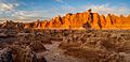
Images for kids
-
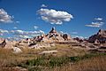
Buttes and pinnacles
-
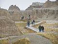
Boardwalk to the Windows
-
Door Trail
-

A southward aerial view of the park, with White River at the top (south) and the small town of Interior upper right center.


Challenges Facing Badlands National Park
Badlands National Park faces some important challenges today. These include concerns about oil and gas pipelines, Native American land rights, the loss of fossils, and climate change.
Oil and Gas Concerns
Oil and gas companies want to build pipelines and drill for fuel near the park. These pipelines can be risky for the environment. If they break, they could harm the park's ecosystems and wildlife.
Native American Land Rights
There is an ongoing discussion about who truly owns the land in Badlands National Park. The Oglala Lakota Sioux tribe once lived here. Many people believe the U.S. government should return the land to the tribe. The park has been working to let the tribe manage part of the southern unit. This would create jobs and give ownership back to the people who were moved from their homes long ago.
Protecting Fossils
Badlands National Park was first created to protect its many fossils. But since the park opened, some visitors and fossil hunters have been taking fossils. They might keep them or sell them for money. This means the park is losing important parts of its history.
Climate Change Impacts
Experts predict that by 2050, Badlands National Park will have different weather. This could mean warmer or cooler temperatures, changes in spring rain, and more heavy rain events. Long summer droughts are also expected to become more common. Over the years, the counties where the park is located have already seen a gradual warming and drying trend.
The park is making plans to deal with these climate changes. They are focusing on protecting native plants, bison, and endangered species. They also want to preserve archaeological sites and fossils. These plans aim to help the park stay healthy for future generations.
See also
 In Spanish: Parque nacional Badlands para niños
