
Porcupine, South Dakota facts for kids
Quick facts for kids
Porcupine, South Dakota
pȟahíŋ siŋté
|
|
|---|---|

Location in Oglala Lakota County and the state of South Dakota
|
|

Porcupine, South Dakota
Location in South Dakota

Porcupine, South Dakota
Location in the United States
|
|
| Country | United States |
| State | South Dakota |
| County | Oglala Lakota |
| Area | |
| • Total | 9.59 sq mi (24.83 km2) |
| • Land | 9.59 sq mi (24.83 km2) |
| • Water | 0.00 sq mi (0.00 km2) |
| Elevation | 3,288 ft (1,002 m) |
| Population
(2020)
|
|
| • Total | 925 |
| • Density | 96.48/sq mi (37.25/km2) |
| Time zone | UTC−7 (Mountain (MST)) |
| • Summer (DST) | UTC−6 (MDT) |
| ZIP code |
57772
|
| Area code(s) | 605 |
| FIPS code | 46-51340 |
| GNIS feature ID | 2393194 |
Porcupine is a small community located in Oglala Lakota County, South Dakota, in the United States. It is known as a census-designated place (CDP), which means it's a special area defined by the U.S. Census Bureau for collecting population data. In the 2020 census, 925 people lived there.
The name "Porcupine" likely comes from Porcupine Butte, a nearby hill. In the Lakota language, Porcupine is called pȟahíŋ siŋté, which means "porcupine tail." This community is also known for being the unofficial capital of the Republic of Lakotah, a group that wants to form an independent Lakota nation.
Contents
About Porcupine
Where is Porcupine?
Porcupine is located in South Dakota. The area of the CDP is about 9.5 square miles (24.6 square kilometers), and all of it is land. There are no large bodies of water within its boundaries.
Culture and Radio
Porcupine is home to KILI, a special radio station (90.1 FM). This non-profit station broadcasts to the Lakota people living on the Pine Ridge Indian Reservation, Cheyenne River Indian Reservation, and Rosebud Indian Reservation. These reservations are part of the larger Great Sioux Nation.
KILI began broadcasting in 1983. It was the very first radio station in the United States owned by American Indians. At the end of 2008, KILI announced that it would start using a wind turbine to power its station, showing a commitment to green energy.
Population Changes Over Time
The number of people living in Porcupine has changed over the years.
| Historical population | |||
|---|---|---|---|
| Census | Pop. | %± | |
| 1990 | 783 | — | |
| 2000 | 407 | −48.0% | |
| 2010 | 1,062 | 160.9% | |
| 2020 | 925 | −12.9% | |
| U.S. Decennial Census | |||
In 2000, there were 407 people living in Porcupine. Most of the people living there were Native American. About 42% of the population was under 18 years old, showing it is a community with many young people.
Schools in Porcupine
The public schools in Porcupine are part of the Oglala Lakota County School District. Lakota Tech High School is the public high school that serves the area.
There is also a campus of Red Cloud Indian School nearby, called Our Lady of Lourdes Elementary School. This school, which has a Porcupine address, was started in 1929 and became part of the Red Cloud System in 1931.
People from Porcupine
Many interesting people have connections to Porcupine:
- Old Chief Smoke: He was an important Oglala Sioux head chief. He is buried southeast of Porcupine.
- Russell Means: He was a well-known activist for American Indian rights and also an actor. He spent time living in Porcupine. In 2007, he worked with others to try and create an independent Lakota nation, which they called the Republic of Lakotah.
- Edgar Bear Runner: He is an activist who helped negotiate during a historical event called the Wounded Knee incident. He also works to support another activist, Leonard Peltier.
Images for kids
-
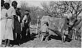
Students at Brave Heart Day School in Porcupine learn to milk a cow, Oct. 2, 1937
-
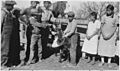
Students at Brave Heart Day School in Porcupine learn to brand a calf, Oct. 2, 1937


See also
 In Spanish: Porcupine (Dakota del Sur) para niños
