Whiteclay, Nebraska facts for kids
Quick facts for kids
Whiteclay, Nebraska
Makȟásaŋ
|
|
|---|---|
| Whiteclay, Nebraska | |

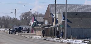
Nebraska Highway 87 forms the main street of Whiteclay
|
|

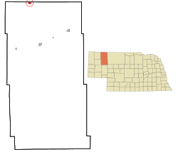
Location of Whiteclay, Nebraska
|
|
| Country | United States |
| State | Nebraska |
| County | Sheridan |
| Area | |
| • Total | 0.07 sq mi (0.18 km2) |
| • Land | 0.07 sq mi (0.18 km2) |
| Population
(2010)
|
|
| • Total | 10 |
| • Density | 142.9/sq mi (55.17/km2) |
| Time zone | UTC-7 (Mountain (MST)) |
| • Summer (DST) | UTC-6 (MDT) |
Whiteclay is a small community in Sheridan County, Nebraska, United States. Its name comes from the Lakota language word Makȟásaŋ, which means "whiteish or yellowish clay". In 2010, only 10 people lived there.
Whiteclay is very close to the Pine Ridge Indian Reservation in South Dakota. For many years, Whiteclay was known for its stores that sold drinks to people from the nearby reservation. This was because selling and having these drinks was not allowed on the reservation. In 2017, the stores in Whiteclay stopped selling these drinks.
History of Whiteclay
Whiteclay's story is closely linked to the Pine Ridge Indian Reservation. Most members of the Oglala Sioux Tribe live on this reservation. The Rosebud Indian Reservation is also nearby in South Dakota.
In 1882, the United States government added a special area of land in Nebraska to the Pine Ridge Reservation. This area was about 50 square miles (130 km²) and was called the White Clay Extension. It was meant to be a "buffer zone." This means it was a protective area to help stop the sale of certain drinks to people on the reservation. The government said this zone would stay until it was no longer needed.
However, in 1904, President Theodore Roosevelt signed an order that removed most of this buffer zone from the reservation. The Oglala Sioux Tribe was not asked if they thought this was a good idea. Soon after, traders set up shops near the reservation border. They started selling drinks, and many of their customers came from the reservation. This trading post grew into the community we know as Whiteclay. Its population was highest in 1940, with 104 people, but it has been much smaller since then.
Changes to Liquor Sales
For a long time, the economy of Whiteclay relied a lot on the sale of drinks. In 2010, the four stores in Whiteclay sold almost 5 million cans of beer. This brought in about $3 million in sales that year.
However, in April 2017, the Nebraska Liquor Control Commission made a big decision. They decided not to renew the licenses for the four stores that sold drinks in Whiteclay. They said there wasn't enough law enforcement in the area. The stores were allowed to sell until their licenses ran out at the end of April 2017. The store owners tried to fight this decision in court, but they lost their appeal. Since then, the town has become much quieter.
Whiteclay's Location
Whiteclay is located in Nebraska. For the 2000 Census, Whiteclay was mistakenly called 'Pine Ridge' in reports. But for the 2010 Census and all future reports, its name was correctly changed back to 'Whiteclay'. A small part of the Pine Ridge Reservation actually extends into the Whiteclay area in Nebraska.
According to the United States Census Bureau, Whiteclay is a census-designated place (CDP). This means it's an area that the Census Bureau defines for gathering population data, even though it's not an official town or city. The Whiteclay CDP covers about 1.0 square mile (2.5 km²). Most of this area is land, with a small amount of water.
People of Whiteclay
In 2000, there were 14 people living in Whiteclay. These people lived in seven households, and three of these were families. The population density was about 15.8 people for every square mile.
The people living in Whiteclay were made up of different groups. About 64% were Native American, and about 36% were White.
 | May Edward Chinn |
 | Rebecca Cole |
 | Alexa Canady |
 | Dorothy Lavinia Brown |


