Lyman, Nebraska facts for kids
Quick facts for kids
Lyman, Nebraska
|
|
|---|---|
|
Village
|
|

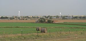
Lyman, seen from the former Nebraska Link 79C to the northwest, September 2013
|
|

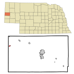
Location of Lyman, Nebraska
|
|
| Country | United States |
| State | Nebraska |
| County | Scotts Bluff |
| Area | |
| • Total | 0.31 sq mi (0.80 km2) |
| • Land | 0.31 sq mi (0.80 km2) |
| • Water | 0.00 sq mi (0.00 km2) |
| Elevation | 4,049 ft (1,234 m) |
| Population
(2020)
|
|
| • Total | 259 |
| • Density | 835.48/sq mi (322.13/km2) |
| Time zone | UTC-7 (Mountain (MST)) |
| • Summer (DST) | UTC-6 (MDT) |
| ZIP code |
69352
|
| Area code(s) | 308 |
| FIPS code | 31-29715 |
| GNIS feature ID | 2399205 |
Lyman is a small village located in Scotts Bluff County, Nebraska, in the United States. It's part of the wider Scottsbluff, Nebraska area. In 2020, about 259 people lived in Lyman.
Contents
The Story of Lyman
Lyman is very close to the Wyoming border. It sits south of Horse Creek, which is a small river that flows into the North Platte River in western Nebraska. This area has a dry climate, meaning it doesn't get a lot of rain. Because of this, the region didn't grow as quickly as other parts of Nebraska that had more water.
Lyman officially became a village in 1922. This happened when the Union Pacific Railroad built its tracks to reach this spot. The village got its name from two bankers, Charles and W. H. Lyman.
Lyman's Location and Size
Lyman is a small place. According to the United States Census Bureau, the village covers a total area of about 0.80 square kilometers (0.31 square miles). All of this area is land, with no water within the village limits.
People of Lyman
How Many People Live Here?
The number of people living in Lyman has changed over the years. Every ten years, the United States counts its population in something called a census. Here's how Lyman's population has looked:
| Historical population | |||
|---|---|---|---|
| Census | Pop. | %± | |
| 1930 | 656 | — | |
| 1940 | 672 | 2.4% | |
| 1950 | 666 | −0.9% | |
| 1960 | 626 | −6.0% | |
| 1970 | 561 | −10.4% | |
| 1980 | 551 | −1.8% | |
| 1990 | 452 | −18.0% | |
| 2000 | 421 | −6.9% | |
| 2010 | 341 | −19.0% | |
| 2020 | 259 | −24.0% | |
| U.S. Decennial Census | |||
What the 2010 Census Showed
In 2010, the census counted 341 people living in Lyman. These people lived in 137 different homes, and 90 of those were families. The village had about 852 people per square mile. There were 165 housing units in total.
Most of the people in Lyman were White (78.0%). About 21.4% were from other races, and a small number were Asian or from two or more races. A significant part of the population, 41.3%, identified as Hispanic or Latino.
About 35% of homes had children under 18 living there. Many homes (48.2%) were married couples. The average home had about 2.49 people, and the average family had about 3.06 people. The average age of people in Lyman was 38.5 years.
Roads in Lyman
Two main routes help people get around Lyman and to other places:
 N-92 - This is a road that goes from east to west through Lyman. It shares its path with N Street inside the village.
- Holloway Road - This road used to be called
 Nebraska Link 79C. It leads north from Lyman to the town of Henry.
See also
 In Spanish: Lyman (Nebraska) para niños
 | Frances Mary Albrier |
 | Whitney Young |
 | Muhammad Ali |


