
Numerical weather prediction facts for kids


Numerical weather prediction is how scientists use powerful computers to guess what the weather will be like in the future. They do this by using special computer programs called models. These models are like virtual versions of Earth's atmosphere. They use math and physics rules to describe how the weather is right now and how it will change over time. By feeding in current weather information, these models can predict things like temperature, wind speed, and pressure for the next few hours or days. Because these calculations are very complex and need a lot of power, supercomputers are often used.
Contents
How do weather models work?
Imagine the Earth's atmosphere as a giant fluid, like water in a swimming pool. Numerical weather prediction starts by taking a snapshot of this "fluid" at a certain moment. Scientists use special equations from fluid dynamics (the study of how fluids move) and thermodynamics (the study of heat and energy) to figure out what the atmosphere will look like in the future.
These models divide the Earth and its atmosphere into a huge 3D grid, like tiny boxes stacked up. Inside each box, the model calculates different weather conditions. It then uses these calculations to predict how the conditions in each box will change and interact with neighboring boxes. This helps create a picture of future weather.
Why local forecasts are tricky
Even with powerful computers, it's hard for these models to predict the exact weather for a very small area, like your backyard. The results are usually more accurate for larger regions. This is why human meteorologists (weather scientists) are still very important! They look at the computer model's predictions and compare them with past weather patterns and their own knowledge. They then use all this information to create the most accurate local weather forecast for you.
One way to make forecasts more accurate is using something called Model Output Statistics (MOS). This is a method developed in the 1960s and 1970s. MOS uses historical weather data and statistical math to automatically improve the computer's predictions. It helps correct small errors the models might have.
A well-known weather model is the Global Forecast System (GFS). The GFS is run by the US weather service, NOAA. It provides new forecasts four times a day. Many smaller weather stations use GFS data because it's available for free.
Understanding "Ensemble" forecasts
The atmosphere is a bit like a chaotic system. This means that even a tiny change in the starting weather information can lead to a very different forecast later on. Think of it like a butterfly flapping its wings in one place causing a storm somewhere else – a small change can have big effects!
Because of this, scientists don't just run the weather model once. They run it many times, creating what's called an "ensemble" forecast. Each time, they slightly change the starting conditions. This creates a group of slightly different forecasts.
After all these calculations are done, scientists compare the results. If many of the forecasts in the ensemble are similar, it means they are more confident in the prediction. This can help them accurately predict the weather for up to about ten days. However, if the forecasts are very different from each other, it means the prediction is less certain, and even a forecast for a few days might be difficult.
Other pages
Images for kids
-

The ENIAC was one of the first electronic computers. Here, Betty Jennings and Frances Bilas are working on it.
-
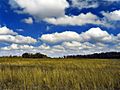
This field of cumulus clouds shows how complex the atmosphere is. Clouds like these are too small for models to see individually, so they are estimated.
-
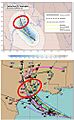
Top: This shows different paths a hurricane (Rita, 2005) might take, according to one model. Bottom: This shows the spread of predictions from many different models.
-
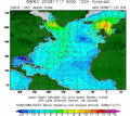
This image shows a 120-hour forecast for wind and waves in the North Atlantic Ocean.


See also
 In Spanish: Modelo numérico de predicción meteorológica para niños
