Crab Orchard, Kentucky facts for kids
Quick facts for kids
Crab Orchard, Kentucky
|
|
|---|---|

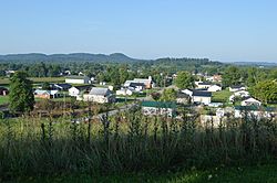
Overview from the city cemetery
|
|

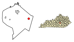
Location in Lincoln County, Kentucky
|
|
| Country | United States |
| State | Kentucky |
| County | Lincoln |
| Area | |
| • Total | 1.76 sq mi (4.55 km2) |
| • Land | 1.75 sq mi (4.52 km2) |
| • Water | 0.01 sq mi (0.03 km2) |
| Elevation | 942 ft (287 m) |
| Population
(2020)
|
|
| • Total | 744 |
| • Density | 426.12/sq mi (164.54/km2) |
| Time zone | UTC-5 (Eastern (EST)) |
| • Summer (DST) | UTC-4 (EDT) |
| ZIP code |
40419
|
| Area code(s) | 606 |
| FIPS code | 21-17956 |
| GNIS feature ID | 2404143 |
Crab Orchard is a small city in Lincoln County, Kentucky, in the United States. It is known as a "home rule-class city." This means it has the power to govern itself on local matters. In 2010, about 841 people lived there. By 2020, the population was 744. Crab Orchard is part of the area around Danville, Kentucky.
History of Crab Orchard
Crab Orchard was an important stop for early settlers. It was located near the end of the Logan Trace. This was a path that connected to the famous Wilderness Road. Pioneers used these roads to travel into new lands.
The area around Crab Orchard has many natural mineral springs. From 1827 to 1922, people built hotels and taverns there. Visitors came to enjoy the springs. The city's post office opened in 1815. Archibald Shanks was the first postmaster.
Crab Orchard also had a station on the Louisville and Nashville Railroad. This railroad helped connect the city to other places.
A famous person named Thomas L. Smith was born in Crab Orchard. He was known as "Pegleg" Smith and was a well-known mountain man.
Geography of Crab Orchard
Crab Orchard is in the eastern part of Lincoln County. It is located in a unique area called the Knobs region. This region has many cone-shaped hills. The city is about 3 miles west of the Rockcastle County border.
U.S. Route 150 goes around the city. This road leads northwest to Stanford, Kentucky, which is the county seat. It also goes southeast to Mount Vernon, Kentucky. Kentucky Route 39 passes through Crab Orchard as Main Street. It goes north to Lancaster, Kentucky and south to Somerset, Kentucky.
The United States Census Bureau says Crab Orchard covers about 4.6 square kilometers. Most of this area is land. Only a small part, about 0.03 square kilometers, is water. The city is also about 1 mile southwest of the Dix River. The Dix River flows into the Kentucky River.
Population of Crab Orchard
| Historical population | |||
|---|---|---|---|
| Census | Pop. | %± | |
| 1830 | 234 | — | |
| 1860 | 364 | — | |
| 1870 | 631 | 73.4% | |
| 1880 | 538 | −14.7% | |
| 1890 | 453 | −15.8% | |
| 1900 | 385 | −15.0% | |
| 1910 | 467 | 21.3% | |
| 1920 | 493 | 5.6% | |
| 1930 | 576 | 16.8% | |
| 1940 | 705 | 22.4% | |
| 1950 | 757 | 7.4% | |
| 1960 | 808 | 6.7% | |
| 1970 | 861 | 6.6% | |
| 1980 | 843 | −2.1% | |
| 1990 | 825 | −2.1% | |
| 2000 | 842 | 2.1% | |
| 2010 | 841 | −0.1% | |
| 2020 | 744 | −11.5% | |
| U.S. Decennial Census | |||
The population of Crab Orchard has changed over many years. In 1830, there were 234 people. The population grew to 842 people by the year 2000. In 2010, the population was 841. By 2020, it was 744 people.
The average age of people in Crab Orchard in 2000 was 37 years old. About 25.9% of the people were under 18 years old. About 20.4% were 65 years or older.
See also
 In Spanish: Crab Orchard (Kentucky) para niños
 | John T. Biggers |
 | Thomas Blackshear |
 | Mark Bradford |
 | Beverly Buchanan |

